Typhoon Ampil Expected to Bring Heavy Rain in Tokyo, Neighboring Areas; JMA Advises Caution Against Storms, Waves

The Japan Meteorological Agency in Minato Ward, Tokyo
16:52 JST, August 15, 2024
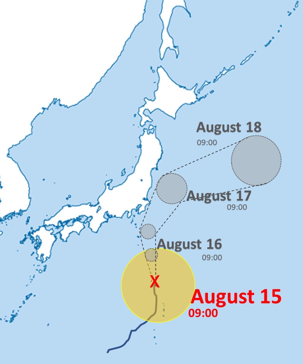
Typhoon Ampil developed and moved northward near the Ogasawa Islands on Thursday and is expected to bring strong wind and heavy rain to the Izu Islands and the Kanto region on Friday.
The Japan Meteorological Agency raised an alert for possible disasters due to heavy rain and urged people to exercise greater caution against storms and high waves.
According to the agency, in the 24-hour period to Friday noon, the typhoon, also known as Typhoon No.7, is forecast to bring 200 millimeters of rainfall in the Kanto-Koshin region and on the Izu Islands. In the 24-hour period to Saturday noon, 200 millimeters of rain is predicted in the Kanto-Koshin region and 100 millimeters is expected on the Izu Islands. A maximum wind speed of 162 kph is expected on land in the Kanto region on Friday.
The typhoon is likely to cause major disruptions to public transportation systems. JR and other companies have called for people to take precautions such as considering changing their itineraries, as the typhoon’s approach will coincide with people returning from hometowns or other Bon holiday destinations.
East Japan Railway Co. (JR East) announced Thursday that a total of 20 inbound and outbound train services on the Tohoku, Joetsu and Yamagata Shinkansen lines will be canceled from around 11 a.m. Friday through the end of the day. Train services on the Hokuriku and Akita Shinkansen lines could also be canceled or delayed.
According to Central Japan Railway Co. (JR Tokai), in addition to the cancellation of Tokaido Shinkansen train service between Tokyo and Nagoya stations on Friday, there is a possibility of significant delays, cancellations or suspensions of some train services on the Tokaido Shinkansen line on Saturday, depending on conditions, including equipment inspections.
JR Tokai has asked travelers to consider changing their plans while paying attention to weather information and train operation status.
According to the weather agency, the typhoon was moving northward at 20 kph at a point about 300 kilometers north-northwest of Chichijima Island, which is part of the Ogasawara Islands, as of 9 a.m. on Thursday. Its central atmospheric pressure was 970 hectopascals with a maximum wind speed of 126 kph d near the center.


Related Tags


Most Read
Popular articles in the past 24 hours
-

BOJ Keeping Eye on Economy and Takaichi's ‘Proactive Fiscal Polic...
-

University of Tsukuba Hospital to Introduce Working Dog Next Year...
-

Record 167 Elementary School Students Harmed Via Social Media in ...
-

Japan’s Hikonyan Cat Mascot to Celebrate 20th Birthday with Party...
-

Japan's Kairos Rocket Set to Launch on Sunday After Delays
-

Humbert Humbert: Husband-Wife Vocal Duo Brings Cheerful Singing t...
-

Nidec Chairman Resigns Amid Accounting Scandal at Major Japanese ...
-

Mizuho to Cut Up to 5,000 Administrative Jobs with AI-Driven Oper...
Popular articles in the past week
-

Producer Behind Pop Group XG Arrested for Cocaine Possession
-

iPS Treatments Pass Key Milestone, but Broader Applications Far f...
-

Tokyo Skytree's Elevator Stops, Trapping 20 People; All Rescued (...
-

Nepal Bus Crash Kills 19 People, Injures 25 Including One Japanes...
-

Milano Cortina 2026: Japanese Gold Medalist Figure Skater Miura S...
-

Japan’s Major Real Estate Firms Expanding Overseas Businesses to ...
-

Milano Cortina 2026: Japanese Figure Skater Kaori Sakamoto’...
-

Reciprocal Tariffs Ruled Illegal: Judiciary Would Not Tolerate Pr...
Popular articles in the past month
-
Producer Behind Pop Group XG Arrested for Cocaine Possession
-

Japan PM Takaichi’s Cabinet Resigns en Masse
-

Japan Institute to Use Domestic Commercial Optical Lattice Clock ...
-

Man Infected with Measles Reportedly Dined at Restaurant in Tokyo...
-

Israeli Ambassador to Japan Speaks about Japan’s Role in the Reco...
-

Videos Plagiarized, Reposted with False Subtitles Claiming ‘Ryuky...
-

Man Infected with Measles May Have Come in Contact with Many Peop...
-

Prudential Life Insurance Plans to Fully Compensate for Damages C...
Top Articles in Society
-
Producer Behind Pop Group XG Arrested for Cocaine Possession
-
Man Infected with Measles Reportedly Dined at Restaurant in Tokyo Station
-
Man Infected with Measles May Have Come in Contact with Many People in Tokyo, Went to Store, Restaurant Around When Symptoms Emerged
-

Woman with Measles Visited Hospital in Tokyo Multiple Times Before Being Diagnosed with Disease
-

Australian Woman Dies After Mishap on Ski Lift in Nagano Prefecture
JN ACCESS RANKING
-
Producer Behind Pop Group XG Arrested for Cocaine Possession
-
Japan PM Takaichi’s Cabinet Resigns en Masse
-
Man Infected with Measles Reportedly Dined at Restaurant in Tokyo Station
-
Israeli Ambassador to Japan Speaks about Japan’s Role in the Reconstruction of Gaza
-
Videos Plagiarized, Reposted with False Subtitles Claiming ‘Ryukyu Belongs to China’; Anti-China False Information Also Posted in Japan