11:46 JST, September 19, 2025
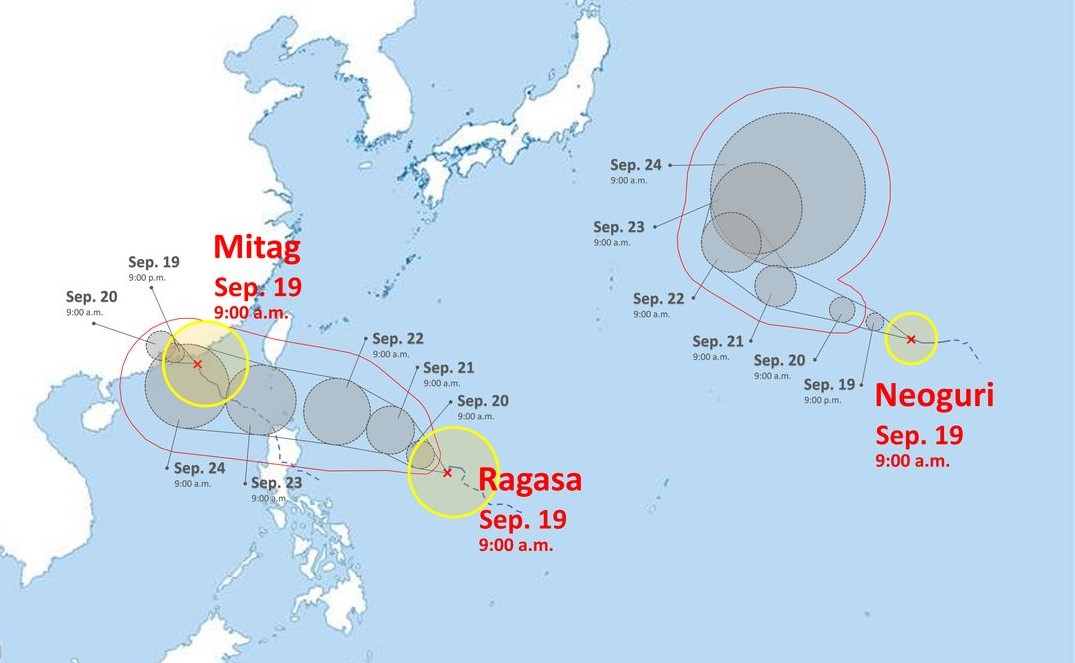
Three typhoons formed in succession in the seas south of Japan on Thursday, according to the Japan Meteorological Agency.
Typhoon Mitag (Typhoon No. 17) formed in the South China Sea at around 3 p.m., Typhoon Ragasa (Typhoon No. 18) formed in waters east of the Philippines at around 9 p.m., and Typhoon Neoguri (Typhoon No. 19) formed near Wake Island at around 9 p.m.
According to the Japan Weather Association, Typhoon Mitag was in the South China Sea, moving west-northwest at 20 kph, as of 9 a.m. Friday. Its central pressure is 1,000 hectopascals, with maximum instantaneous wind speeds of 108 kph. The typhoon is expected to weaken into a tropical depression later.
Typhoon Ragasa is moving slowly west in the waters east of the Philippines. Its central pressure is 998 hectopascals, with maximum instantaneous wind speeds of 108 kph. It is expected to reach the South China Sea at 9 a.m. on Wednesday.
Typhoon Neoguri is located near Wake Island, moving west at 15 kph. Its central pressure is 1,004 hectopascals, with maximum instantaneous wind speeds of 126 kph. It will reach the waters off Minamitorishima Island on Friday night and east of Japan on Monday night.
Related Tags


Most Read
Popular articles in the past 24 hours
-

Japan’s Major Real Estate Firms Expanding Overseas Businesses to ...
-

Ukrainian Ambassador Closely Watching Japan’s Revision of Defense...
-

Milano Cortina 2026: Sakamoto Serves as Flag Bearer; Japan Earns ...
-

Emperor Turns 66 Ahead of Disaster Milestones
-

Milano Cortina 2026: There Were Cheers across the Country, after ...
-

Luna Sea Drummer Shinya Dies at 56; Powerful Drummer Behind ‘Desi...
-

Milano Cortina 2026: ‘Magical’ Italian Games Close wi...
-

Milano Cortina 2026: Riku-Ryu Duo Stick Together During Closing C...
Popular articles in the past week
-

Japan PM Takaichi’s Cabinet Resigns en Masse
-

Man Infected with Measles Reportedly Dined at Restaurant in Tokyo...
-

Sanae Takaichi Elected Prime Minister of Japan; Keeps All Cabinet...
-

Japan's Govt to Submit Road Map for Growth Strategy in March, PM ...
-

Bus Carrying 40 Passengers Catches Fire on Chuo Expressway; All E...
-

Milano Cortina 2026: Figure Skaters Riku Miura, Ryuichi Kihara Pa...
-

Japan, U.S. Name 3 Inaugural Investment Projects; Reached Agreeme...
-

U.S. Firm to Build Training Hub in Fukushima N-plant for Debris R...
Popular articles in the past month
-
Japan PM Takaichi’s Cabinet Resigns en Masse
-

Japan Institute to Use Domestic Commercial Optical Lattice Clock ...
-

Israeli Ambassador to Japan Speaks about Japan’s Role in the Reco...
-
Man Infected with Measles Reportedly Dined at Restaurant in Tokyo...
-

Videos Plagiarized, Reposted with False Subtitles Claiming ‘Ryuky...
-

Man Infected with Measles May Have Come in Contact with Many Peop...
-

Prudential Life Insurance Plans to Fully Compensate for Damages C...
-

Woman with Measles Visited Hospital in Tokyo Multiple Times Befor...
Top Articles in Society
-

Producer Behind Girls Group XG Arrested for Cocaine Possession
-
Man Infected with Measles Reportedly Dined at Restaurant in Tokyo Station
-
Man Infected with Measles May Have Come in Contact with Many People in Tokyo, Went to Store, Restaurant Around When Symptoms Emerged
-
Woman with Measles Visited Hospital in Tokyo Multiple Times Before Being Diagnosed with Disease
-

Australian Woman Dies After Mishap on Ski Lift in Nagano Prefecture
JN ACCESS RANKING
-
Japan PM Takaichi’s Cabinet Resigns en Masse
-
Japan Institute to Use Domestic Commercial Optical Lattice Clock to Set Japan Standard Time
-
Israeli Ambassador to Japan Speaks about Japan’s Role in the Reconstruction of Gaza
-
Man Infected with Measles Reportedly Dined at Restaurant in Tokyo Station
-
Videos Plagiarized, Reposted with False Subtitles Claiming ‘Ryukyu Belongs to China’; Anti-China False Information Also Posted in Japan