Typhoon Shanshan becomes ‘strong,’ predicted to reach Japan’s Kyushu, Shikoku regions on Tuesday
14:54 JST, August 24, 2024
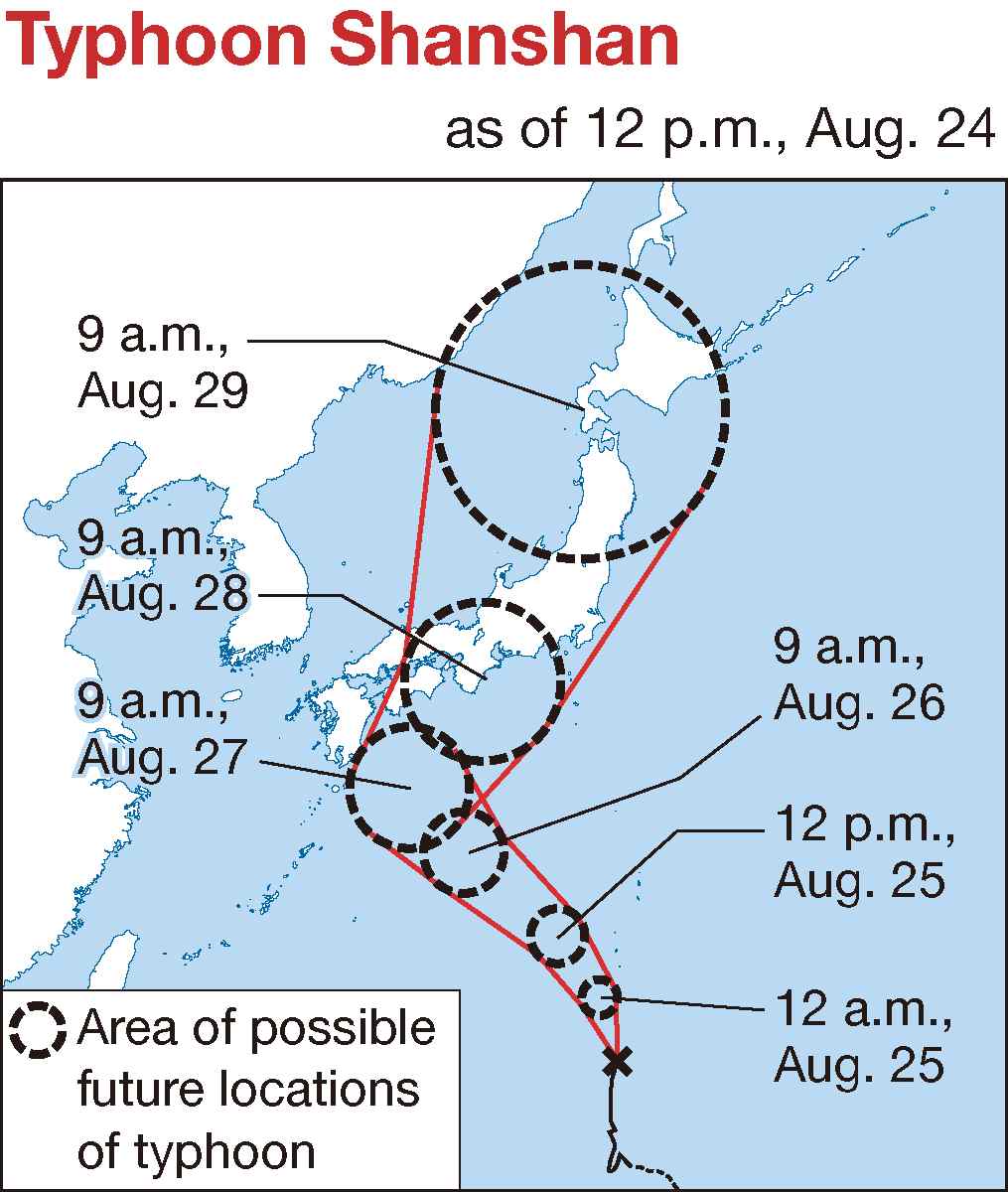
The Japan Meteorological Agency reported that Typhoon Shanshan became a “strong” one on Saturday morning, with atmospheric pressure reaching 980 hectopascals and a maximum wind speed of 35 meters per second at its center.
The typhoon was heading north over the sea near the Ogasawara island chain at a speed of 25 kilometers per hour as of 9 a.m. on Saturday.
The agency has predicted that the typhoon’s route will bring it close to Kyushu and Shikoku regions at 9 a.m. on Tuesday.
At the time, they estimate that the typhoon’s atmospheric pressure at the center will be 950 hectopascals and its maximum wind speed at the center will be 45 m/s.
The agency predicted that the typhoon will be a “very strong” one at the time.

Related Tags


Most Read
Popular articles in the past 24 hours
-

BOJ Keeping Eye on Economy and Takaichi's ‘Proactive Fiscal Polic...
-

University of Tsukuba Hospital to Introduce Working Dog Next Year...
-
Record 167 Elementary School Students Harmed Via Social Media in ...
-

Mizuho Bank May Have Lost Data on Thousands of Clients
-

Bernini, Barberini Celebrated as Vatican Marks 400 Years of St. P...
-

The Japan News / Weekly Edition (2/27-3/5)
-

Japan’s Hikonyan Cat Mascot to Celebrate 20th Birthday with Party...
-

Japan's Kairos Rocket Set to Launch on Sunday After Delays
Popular articles in the past week
-
Producer Behind Pop Group XG Arrested for Cocaine Possession
-

iPS Treatments Pass Key Milestone, but Broader Applications Far f...
-

Tokyo Skytree's Elevator Stops, Trapping 20 People; All Rescued (...
-

Milano Cortina 2026: Japanese Gold Medalist Figure Skater Miura S...
-

Nepal Bus Crash Kills 19 People, Injures 25 Including One Japanes...
-

Japan’s Major Real Estate Firms Expanding Overseas Businesses to ...
-

Milano Cortina 2026: Japanese Figure Skater Kaori Sakamoto’...
-

Reciprocal Tariffs Ruled Illegal: Judiciary Would Not Tolerate Pr...
Popular articles in the past month
-
Producer Behind Pop Group XG Arrested for Cocaine Possession
-

Japan PM Takaichi’s Cabinet Resigns en Masse
-

Japan Institute to Use Domestic Commercial Optical Lattice Clock ...
-

Man Infected with Measles Reportedly Dined at Restaurant in Tokyo...
-

Israeli Ambassador to Japan Speaks about Japan’s Role in the Reco...
-

Videos Plagiarized, Reposted with False Subtitles Claiming ‘Ryuky...
-

Man Infected with Measles May Have Come in Contact with Many Peop...
-

Prudential Life Insurance Plans to Fully Compensate for Damages C...
Top Articles in Society
-
Producer Behind Pop Group XG Arrested for Cocaine Possession
-
Man Infected with Measles Reportedly Dined at Restaurant in Tokyo Station
-
Man Infected with Measles May Have Come in Contact with Many People in Tokyo, Went to Store, Restaurant Around When Symptoms Emerged
-
Woman with Measles Visited Hospital in Tokyo Multiple Times Before Being Diagnosed with Disease
-
Australian Woman Dies After Mishap on Ski Lift in Nagano Prefecture
JN ACCESS RANKING
-
Producer Behind Pop Group XG Arrested for Cocaine Possession
-
Japan PM Takaichi’s Cabinet Resigns en Masse
-
Man Infected with Measles Reportedly Dined at Restaurant in Tokyo Station
-
Israeli Ambassador to Japan Speaks about Japan’s Role in the Reconstruction of Gaza
-
Videos Plagiarized, Reposted with False Subtitles Claiming ‘Ryukyu Belongs to China’; Anti-China False Information Also Posted in Japan