Typhoon Precursors Form in Succession Over Japan’s Southern Sea; Situation Unlikely to Change Soon
16:55 JST, August 16, 2024
Four typhoons including the current Typhoon Ampil — also known as Typhoon No. 7 — formed one after another over the sea south of Japan between Aug. 8 and Tuesday.
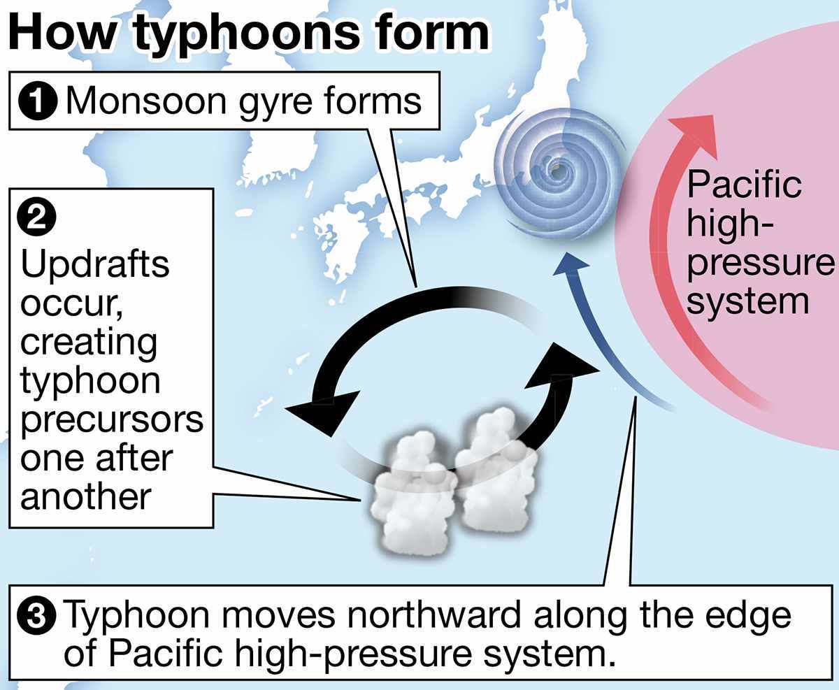
According to the Japan Meteorological Agency (JMA), the presence of a low-pressure atmospheric vortex — called a monsoon gyre — has increased the likelihood that typhoons will form.
A high-pressure system in the Pacific is currently far to the east over the sea south of Japan, and a nearby low-pressure system is expanding, bringing with it anticlockwise wind circulation, which can easily create updrafts. Accordingly, clusters of cumulonimbus clouds, the precursors of typhoons, are forming one after another.
Additionally, sea surface temperatures in the area this year are about 2 C higher than normal, a situation that is adding a large amount of water vapor to the air. This is another condition that is ripe for typhoons.
Nagoya University Prof. Kazuhisa Tsuboki, who studies typhoons, spoke about the cause of this consecutive development of cumulonimbus clouds: “There have been few typhoons so far this year, and the sea had not been stirred up until recently.”
Typhoon Ampil moved northward along the edge of the high-pressure system in the Pacific. JMA said that the typhoon-prone conditions are not expected to go away any time soon and the agency would keep monitoring the development of subsequent typhoons.

Powerful Typhoon Ampil Approaches Chiba Prefecture; Regional Train, Ferry Services Halted or Reduced

Related Tags


Most Read
Popular articles in the past 24 hours
-

BOJ Keeping Eye on Economy and Takaichi's ‘Proactive Fiscal Polic...
-

University of Tsukuba Hospital to Introduce Working Dog Next Year...
-
Record 167 Elementary School Students Harmed Via Social Media in ...
-

Mizuho Bank May Have Lost Data on Thousands of Clients
-

Japan’s Hikonyan Cat Mascot to Celebrate 20th Birthday with Party...
-

Japan's Kairos Rocket Set to Launch on Sunday After Delays
-

Humbert Humbert: Husband-Wife Vocal Duo Brings Cheerful Singing t...
-

Mizuho to Cut Up to 5,000 Administrative Jobs with AI-Driven Oper...
Popular articles in the past week
-

Producer Behind Pop Group XG Arrested for Cocaine Possession
-

iPS Treatments Pass Key Milestone, but Broader Applications Far f...
-

Tokyo Skytree's Elevator Stops, Trapping 20 People; All Rescued (...
-

Nepal Bus Crash Kills 19 People, Injures 25 Including One Japanes...
-

Milano Cortina 2026: Japanese Gold Medalist Figure Skater Miura S...
-

Japan’s Major Real Estate Firms Expanding Overseas Businesses to ...
-

Milano Cortina 2026: Japanese Figure Skater Kaori Sakamoto’...
-

Reciprocal Tariffs Ruled Illegal: Judiciary Would Not Tolerate Pr...
Popular articles in the past month
-
Producer Behind Pop Group XG Arrested for Cocaine Possession
-

Japan PM Takaichi’s Cabinet Resigns en Masse
-

Japan Institute to Use Domestic Commercial Optical Lattice Clock ...
-

Man Infected with Measles Reportedly Dined at Restaurant in Tokyo...
-

Israeli Ambassador to Japan Speaks about Japan’s Role in the Reco...
-

Videos Plagiarized, Reposted with False Subtitles Claiming ‘Ryuky...
-

Man Infected with Measles May Have Come in Contact with Many Peop...
-

Prudential Life Insurance Plans to Fully Compensate for Damages C...
Top Articles in Society
-
Producer Behind Pop Group XG Arrested for Cocaine Possession
-
Man Infected with Measles Reportedly Dined at Restaurant in Tokyo Station
-
Man Infected with Measles May Have Come in Contact with Many People in Tokyo, Went to Store, Restaurant Around When Symptoms Emerged
-

Woman with Measles Visited Hospital in Tokyo Multiple Times Before Being Diagnosed with Disease
-

Australian Woman Dies After Mishap on Ski Lift in Nagano Prefecture
JN ACCESS RANKING
-
Producer Behind Pop Group XG Arrested for Cocaine Possession
-
Japan PM Takaichi’s Cabinet Resigns en Masse
-
Man Infected with Measles Reportedly Dined at Restaurant in Tokyo Station
-
Israeli Ambassador to Japan Speaks about Japan’s Role in the Reconstruction of Gaza
-
Videos Plagiarized, Reposted with False Subtitles Claiming ‘Ryukyu Belongs to China’; Anti-China False Information Also Posted in Japan