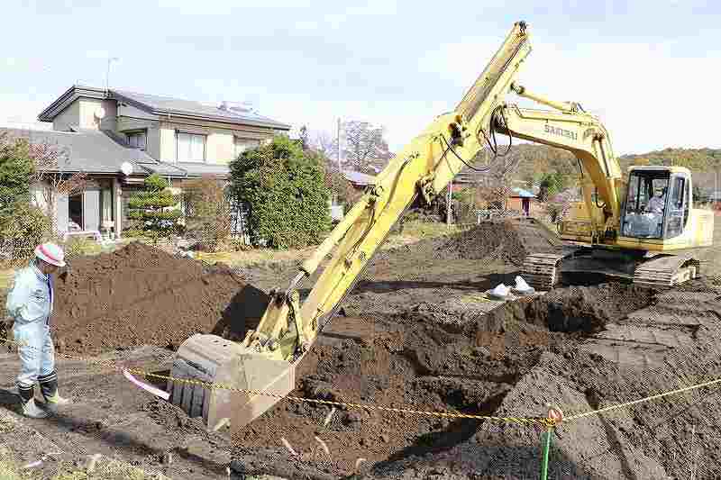
A large-scale excavation survey broke ground in the Kanbara district of Tsumagoi, Gunma Prefecture, on Nov. 1.
November 7, 2021
MAEBASHI — The 1783 eruption of Mt. Asama buried most of present-day Kanbara district in Tsumagoi, Gunma Prefecture in pyroclastic mud and ash. Over two centuries later, a large-scale excavation survey seeks to provide a clearer picture of the area known as “Japanese Pompeii,” and possibly even unearth clues for future disaster prevention.
In 1783, Mt. Asama became active in a series of violent eruptions that sent pumice and volcanic ash raining down mainly to the southeast. Activity culminated on Aug. 5, with a devastating avalanche that flowed all the way to Tokyo Bay and the Pacific Ocean.
The disaster claimed an estimated 1,500 lives total — 477 in the small village of Kanbara alone.
Located at the foot of the volcano, the village was encased under the avalanche, drawing comparison to the ancient Roman city of Pompeii.
Earlier this month, the village’s board of education broke ground on a six-year survey, slated to run through fiscal 2026, that aims to examine how the area recovered from the disaster.
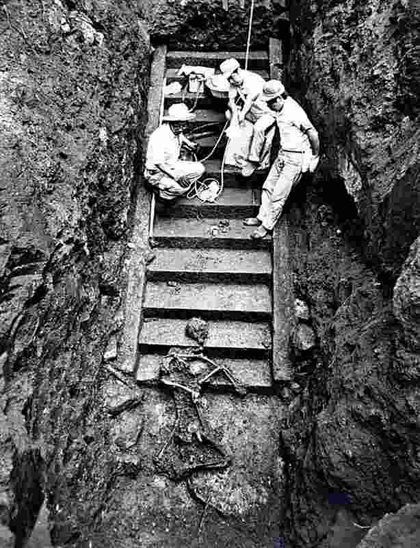
Human remains were discovered on stone steps unearthed in the previous survey.
The survey is the first in the area since 1991, when excavations on a 15-step stone staircase at the Kanbara Kannon-do temple revealed an extra 35 steps that had been long forgotten under soil deposits. The skeletal remains of two women were discovered about 6 meters underground on the steps, where they were believed to have been attempting to evacuate. Three houses were found buried nearby, along with household items such as a mirror.
The board of education has been working to estimate how much of the Kanbara district had been inhabited before the eruption. As such, it plans to deploy heavy machinery to excavate sites that were not included in the scope of the previous survey, such as the area around Kanbara Shrine.
In a first phase this fiscal year, the board will decide on how to proceed with a full survey of the shrine in consultation with specialists.
From the next fiscal year onward, the project will proceed with the excavation of another village that was located on a hill near Mt. Asama.
The team will examine the land for evidence of rice cultivation and other use, in order to retrace how the region gradually recovered from the disaster.
The board hopes to capitalize on the cultural value of excavated items and also aims to have the area designated as a national historic site.
“We intend to proceed with a radar survey to identify artefacts buried underground,” said Toshiaki Seki, director of the Tsumagoi local history museum. “The area is sure to become a symbolic site that conveys the history of reconstruction from volcanic disaster.”
Top Articles in Society
-
Man Infected with Measles Reportedly Dined at Restaurant in Tokyo Station
-

Man Infected with Measles May Have Come in Contact with Many People in Tokyo, Went to Store, Restaurant Around When Symptoms Emerged
-
Woman with Measles Visited Hospital in Tokyo Multiple Times Before Being Diagnosed with Disease
-
Australian Woman Dies After Mishap on Ski Lift in Nagano Prefecture
-
Foreign Snowboarder in Serious Condition After Hanging in Midair from Chairlift in Nagano Prefecture
JN ACCESS RANKING
-

Japan PM Takaichi’s Cabinet Resigns en Masse
-
Japan Institute to Use Domestic Commercial Optical Lattice Clock to Set Japan Standard Time
-

Israeli Ambassador to Japan Speaks about Japan’s Role in the Reconstruction of Gaza
-

Man Infected with Measles Reportedly Dined at Restaurant in Tokyo Station
-

Videos Plagiarized, Reposted with False Subtitles Claiming ‘Ryukyu Belongs to China’; Anti-China False Information Also Posted in Japan


