11:16 JST, February 14, 2022
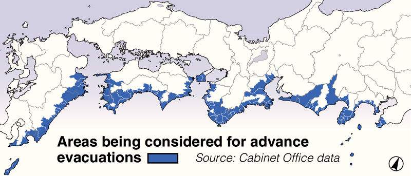
The government plans to develop a framework to map areas where advance evacuations will be issued in the event of a huge Nankai Trough earthquake, which is forecast to occur in the next 30 years.
The system will utilize data from an evacuation drill app developed by Kyoto University and the National Research Institute for Earth Science and Disaster Resilience (NIED).
The ministry will analyze data from the app on evacuation success rates in each region, among other things, and use the analysis to help municipalities devise relevant countermeasures.
The Education, Culture, Sports, Science and Technology Ministry will conduct trials in Kochi and other prefectures this year, aiming to launch the system by fiscal 2024.
There is a 70-80% probability that a Nankai Trough earthquake will occur within the next 30 years, and it is estimated that up to 320,000 people will be killed or be unaccounted for.
In the past, there have been cases where earthquakes occurred simultaneously along the entire length of the Nankai Trough, as well as cases where earthquakes occurred on either the eastern or western part of the Nankai Trough, followed by quakes on the opposite side.
Under a 2019 Cabinet Office proposal, in the event of a Nankai Trough earthquake on either the eastern or western side of the trough, one-week evacuations would be urged for residents in areas at high risk of tsunami in anticipation of a quake on the opposite side of the trough.
This is because, after a massive quake of magnitude 8 or higher on one half of the Nankai Trough region, a quake of similar magnitude occurring on the opposite side is 100 times more likely to occur, according to Cabinet Office estimates.
Advance evacuations will be recommended mainly by municipalities, including areas in Tokyo and 13 other prefectures, including Shizuoka, Mie, Wakayama, and Kochi.
However, data that would serve as a basis for designating such areas has been lacking.
The technology ministry’s framework will utilize data from the Kyoto University and NIED-developed evacuation training smartphone app, which uses the GPS to record location information and includes details about flooding status.
Data such as gender, age, assistance requirements, means of transportation and evacuation success rates will be collected from the app to be used by evacuation drill participants, helping to evaluate the effectiveness of evacuation maps.
Municipalities will utilize the analysis to determine which areas need to be evacuated in advance.
The ministry will analyze data collected from the app during evacuation drills this year in such prefectures as Kochi and Wakayama, and later expand the analysis to include Aichi and Shizuoka, among other prefectures.
The framework is part of a fiscal 2020-24 Nankai Trough quake research project that is expected to contribute to disaster-prevention measures.
An official of the ministry’s earthquake and disaster-reduction research division said, “We hope that by providing objective evidence, it will be easier to gain understanding from the public regarding advance evacuations.”


Most Read
Popular articles in the past 24 hours
-

Ransomware Attacks Hitting Japan's Small, Midsize Firms
-

German Journalist Traces Footsteps of Great-Grandfather Who Was P...
-

10 Foreign Tourists Sustain Injuries After Fire at Capsule Hotel ...
-

World Baseball Classic: Venezuela Beats Japan in Nail-biting Back...
-

Rapid Services Resume on JR Chuo Line; Suspension Caused by Accid...
-

Rapid Services on JR Chuo Line Suspended; Accident at Kokubunji S...
-

World Baseball Classic: Venezuela Beats Japan in Back-and-Forth Q...
-

World Baseball Classic: Red Sox’s Abreu Hits 3-run Homer, Giving ...
Popular articles in the past week
-

Japan Figure Skating Legend Yuzuru Hanyu Is Proud Disaster Surviv...
-
15 Measles Patients Confirmed in Tokyo in Past 6 Days; 1 May Have...
-
Massive Sewer Pipe Found Jutting Out of Highway in Osaka
-

Japan Govt to Tighten Requirements to Receive Permanent Residency...
-
Power Outage Forces About 980 Passengers in Yokohama to Walk to T...
-
JR Tokai Breaks Ground on Yamanashi Maglev Station; Will Be Part ...
-

Parents in Japan to Get Instagram Notifications When Teens Repeat...
-
'World's Oldest Bio-Business' Is Japan's Seed Koji Retailing, Mol...
Popular articles in the past month
-

Producer Behind Pop Group XG Arrested for Cocaine Possession
-

Japan PM Takaichi’s Cabinet Resigns en Masse
-

Man Infected with Measles Reportedly Dined at Restaurant in Tokyo...
-
Japan Figure Skating Legend Yuzuru Hanyu Is Proud Disaster Surviv...
-

iPS Treatments Pass Key Milestone, but Broader Applications Far f...
-

Sanae Takaichi Elected Prime Minister of Japan; Keeps All Cabinet...
-

South Korea Tightens Rules on Foreigners Buying Homes in Seoul Me...
-
Nepal Bus Crash Kills 19 People, Injures 25 Including One Japanes...
Top Articles in Science & Nature
-
iPS Treatments Pass Key Milestone, but Broader Applications Far from Guaranteed
-

Record 700 Startups to Gather at SusHi Tech Tokyo in April; Event Will Center on Themes Like Artificial Intelligence and Robotics
-
Parents in Japan to Get Instagram Notifications When Teens Repeatedly Search for Suicide Content
-
iPS Cell Products for Parkinson’s, Heart Disease OK’d for Commercialization by Japan Health Ministry Panel
-

Japan to Ban Use of Power Banks on Airplanes
JN ACCESS RANKING
-
Producer Behind Pop Group XG Arrested for Cocaine Possession
-
Japan PM Takaichi’s Cabinet Resigns en Masse
-
Man Infected with Measles Reportedly Dined at Restaurant in Tokyo Station
-
Japan Figure Skating Legend Yuzuru Hanyu Is Proud Disaster Survivor and Gold Medalist, Vows to Continue Support Efforts
-
iPS Treatments Pass Key Milestone, but Broader Applications Far from Guaranteed