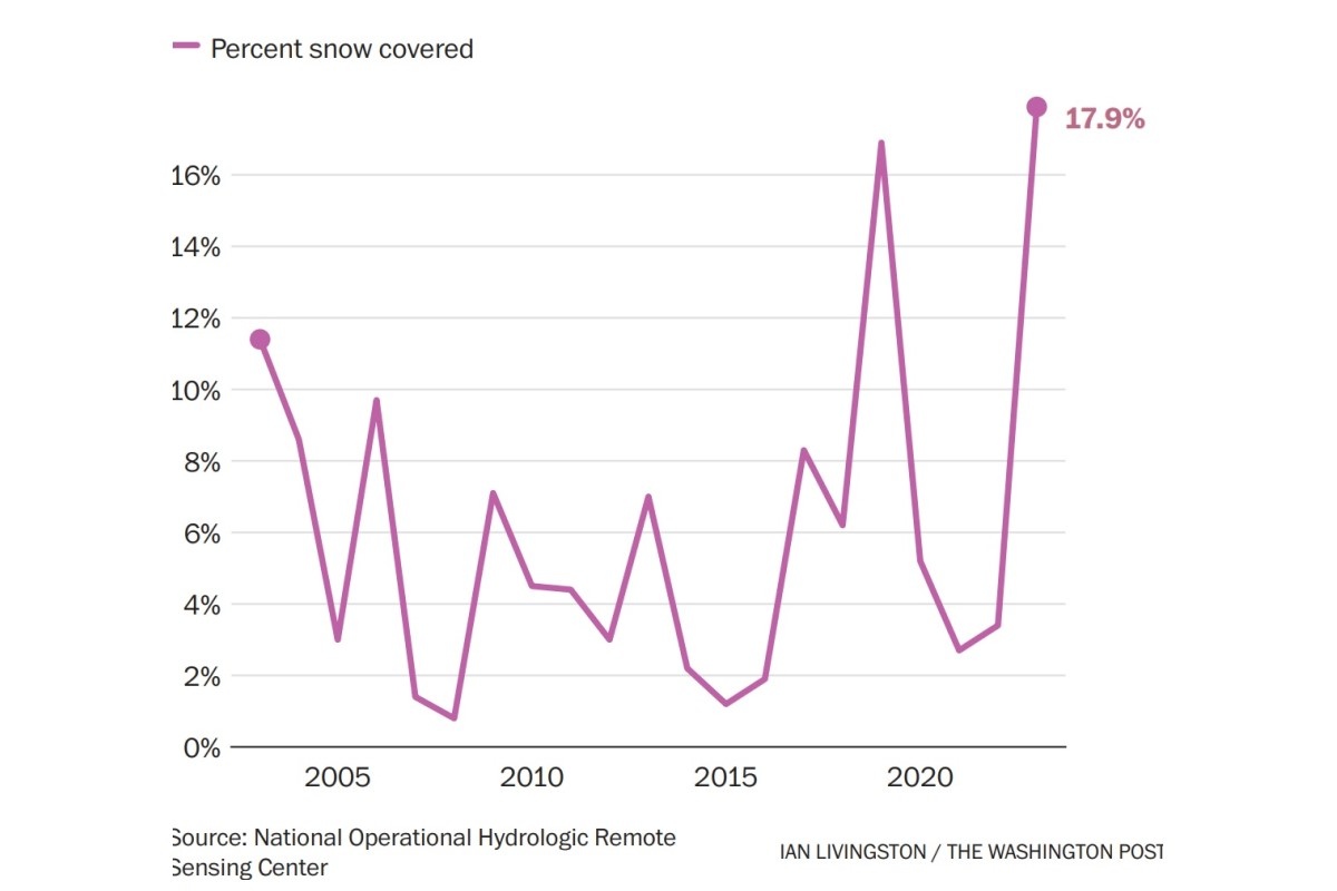
November 1 snow cover across the Lower 48
11:55 JST, November 2, 2023
The season’s first snows have frosted the Rocky Mountains, the northern Plains, the Great Lakes and northern New England over the past week, resulting in the most extensive early-November snow cover in at least two decades.
On Wednesday morning, snow was on the ground in 17.9 percent of the Lower 48, according to the National Oceanic and Atmospheric Administration.
Locations from eastern Minnesota to western New York saw snow on Halloween – even enough to shovel in Minneapolis; Milwaukee; Muskegon, Mich.; and Buffalo. Areas downwind of Lakes Erie and Ontario were also blanketed early Wednesday, including Cleveland and Akron, Ohio, while several inches were anticipated along some of the west-facing slopes of the Appalachian Mountains.
This latest batch of wintry weather comes on the heels of two other storm systems that brought snow to the Mountain West, the northern Plains, the Midwest and northern New England over the past week.
Record-setting cold fuels early-season snow
The current abundance of snow was made possible by a powerful early-season outbreak of cold air. It brought a handful of record lows in the northern Plains on Halloween and in areas to the south and east of there on Wednesday morning.
About 119 million Americans began Wednesday at or below freezing; the temperature averaged over the Lower 48 was 31.3 degrees – more than 10 degrees below average.
Numerous locations across Texas, Oklahoma, Kansas and Missouri flirted with or broke record lows Wednesday morning. This included a teeth-chattering 8 degrees in Mount LeConte, Tenn., in the Smoky Mountains – the location’s earliest single-digit low on record.
A series of storms
Wintry weather started suddenly last week as a storm exited the Pacific Northwest after delivering deep powder to the mountains. The storm went on to blanket the zone from Montana to North Dakota with 6 to 12 inches of snow, while also dragging cold air southward.
A second storm developed in the Rockies over the weekend, burying the Denver region in 4 to 10 inches; up to several feet fell in the mountains to the west, kicking off the ski season at several resorts. This storm also produced snows across the northern Midwest, the Great Lakes and northern New England.
A third atmospheric disturbance produced snow from the northern Plains to the Great Lakes on Halloween and is still going.
Minneapolis opened Halloween with 2 to 4 inches of snow, while much of Minnesota and Wisconsin saw light accumulations. Milwaukee received about 3 inches, and Chicago got an inch. The Muskegon area, on the eastern shore of Lake Michigan, saw about 10 inches.
By Wednesday morning, snow was furiously falling downwind of Lake Erie, affecting Cleveland as well as much of northeast Ohio and northwest Pennsylvania. Through midday, 2 to 6 inches had fallen in the region, with an additional 1 to 3 inches possible. Snow was also falling in the mountains of the Mid-Atlantic on Wednesday, with accumulating snow in western Maryland and flurries as far east as Baltimore’s suburbs.
Snow also extended north through Buffalo and Rochester, N.Y., as well as parts of the Berkshires on Wednesday.
The results
These three storm systems together have covered 17.9 percent of the Lower 48 in snow, the most to start November since such records began in 2003, according to NOAA.
Last year on Nov. 1, snow covered just 3.4 percent of the Lower 48. The 20-year average snow cover over the Lower 48 on Nov. 1 is 5.5 percent.
Several locations have posted historically significant snowfall for this early in the season. With 14 inches through Oct. 31, Glasgow, Mont., has registered its snowiest start to the season on record. Bismarck, N.D., which posted 9.1 inches through the end of last month, has seen its fourth-greatest amount of snow through this date.
Will it last?
All this may leave one wondering if this early blast of snow and cold will stick around. Judah Cohen, a seasonal forecasting expert with Verisk Atmospheric and Environmental Research, said probably not.
“I expect a pretty hasty retreat of snow cover back into Canada,” Cohen told The Washington Post. “It will be interesting to see how much snow can last until the next buildup of Arctic air.”
Computer models suggest that warmer-than-normal conditions will replace the wintry weather over the next week or two. A lot of the snow outside the mountains will probably melt away pretty quickly.


Most Read
Popular articles in the past 24 hours
-

Milano Cortina 2026: Japanese Gold Medalist Figure Skater Miura S...
-

Yokohama to Test Out Renewable-Powered Offshore Floating Data Cen...
-

Japan’s Takaichi Speaks on New U.S. Tariff in Upper House, Says P...
-

Takeshima Day: Persistently Demanding Resolution from South Korea...
-

Japanese Watermelon Shipments Starts in Leading Production Distri...
-

Ishinomaki Man Plush Toy Offers Hope to Children in Times of Disa...
-

Japan Authorities Begin On-site Inspection of Japanese Microsoft ...
-

Nikkei Average Rewrites All-Time Closing High
Popular articles in the past week
-

Producer Behind Pop Group XG Arrested for Cocaine Possession
-

iPS Treatments Pass Key Milestone, but Broader Applications Far f...
-

Japan, U.S. Name 3 Inaugural Investment Projects; Reached Agreeme...
-

Tokyo Skytree's Elevator Stops, Trapping 20 People; All Rescued (...
-

Japan’s Major Real Estate Firms Expanding Overseas Businesses to ...
-
Milano Cortina 2026: Japanese Gold Medalist Figure Skater Miura S...
-

Baby Monkey Punch Captures Hearts at Chiba Pref. Zoo, on Social M...
-

Milano Cortina 2026: Japanese Figure Skater Kaori Sakamoto’...
Popular articles in the past month
-
Producer Behind Pop Group XG Arrested for Cocaine Possession
-

Japan PM Takaichi’s Cabinet Resigns en Masse
-

Japan Institute to Use Domestic Commercial Optical Lattice Clock ...
-

Man Infected with Measles Reportedly Dined at Restaurant in Tokyo...
-

Israeli Ambassador to Japan Speaks about Japan’s Role in the Reco...
-

Videos Plagiarized, Reposted with False Subtitles Claiming ‘Ryuky...
-

Man Infected with Measles May Have Come in Contact with Many Peop...
-

Prudential Life Insurance Plans to Fully Compensate for Damages C...
Top Articles in News Services
-
Survey Shows False Election Info Perceived as True
-

Hong Kong Ex-Publisher Jimmy Lai’s Sentence Raises International Outcry as China Defends It
-
Japan’s Nikkei Stock Average Touches 58,000 as Yen, Jgbs Rally on Election Fallout (UPDATE 1)
-
Japan’s Nikkei Stock Average Falls as US-Iran Tensions Unsettle Investors (UPDATE 1)
-

Trump Names Former Federal Reserve Governor Warsh as the Next Fed Chair, Replacing Powell
JN ACCESS RANKING
-
Producer Behind Pop Group XG Arrested for Cocaine Possession
-
Japan PM Takaichi’s Cabinet Resigns en Masse
-
Man Infected with Measles Reportedly Dined at Restaurant in Tokyo Station
-
Israeli Ambassador to Japan Speaks about Japan’s Role in the Reconstruction of Gaza
-
Videos Plagiarized, Reposted with False Subtitles Claiming ‘Ryukyu Belongs to China’; Anti-China False Information Also Posted in Japan