
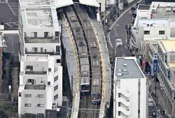
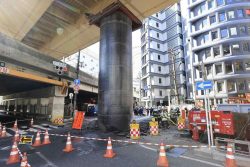
Ring Road No. 2 — at center and known as the MacArthur road — runs through buildings.
16:38 JST, August 29, 2023
This is the fourth installment in a series looking at lessons that have been learned over the past 100 years since the Great Kanto Earthquake as Tokyo enters a new era of urban development.
***
When talking about urban development, the subject of road networks must come up.
There are still “missing links” in Tokyo’s ring road system. One is the so-called MacArthur road, a former military road that ran in a straight line between the U.S. Embassy in Tokyo’s Toranomon district and Tokyo Bay. It was purportedly named after U.S. Gen. Douglas MacArthur.
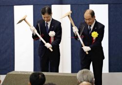
Sotobori-dori avenue, or Ring Road No. 2, runs from Akasaka through Shimbashi to the Ginza and Kanda districts. Originally, Ring Road No. 2 was supposed to split in Toranomon and lead to the Ariake in Tokyo Bay area through Shiodome and Harumi. For many years, an about 1.3-kilometer section between Toranomon and Shimbashi was not connected, so the construction of this portion drew much attention when it finally started.
“It looks like Godzilla walked through here,” it was said when the construction began in 2003, as a straight line of buildings was demolished. Because many low-rise buildings stood in areas that had been devastated by World War II, many had considered it impossible to build a road in the area. Opposition from local residents also delayed the opening of the road.
Progress began to be made as more and more people finally started to support the construction, on conditions such as addressing tax inequalities. Half a century had passed since the plan was decided on, and older generations had been replaced by younger. Many residents were also dealing with difficulties related to inheriting the land.
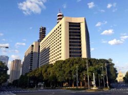
All sections were built and connected in December 2022. Use of a multi-level road system, which allows for the construction of roads and buildings in the same place, made it possible to build the Toranomon Hills building above the road.
Initially, the entire road was planned to be opened before the Tokyo Olympics and Paralympics. However, this did not occur due to a delay in the relocation of the Tsukiji fish market to Toyosu. Drivers who take the Metropolitan Expressway Bayshore Route via the new road can get from Toranomon to Haneda Airport, a distance of about 20 kilometers, in about 20 minutes.
Foreign VIPs prefer chauffeur-driven cars for transportation, as metropolitan expressways run through busy shopping areas and their lanes are narrow. With the new road, they can avoid sections where they could get caught in traffic.

Origin of stripe patterns
There are eight ring roads that are well known to Tokyo residents, including Meiji-dori avenue, Yamate-dori avenue, Kannana-dori avenue and Kanpachi-dori avenue.
“The Imperial Palace is in the center of Tokyo, so the road network developed in concentric circles. This is a rare shape not seen in other countries, and allows for smooth vehicle traffic,” said Yasushi Aoyama, a professor emeritus at Meiji University and former vice governor of Tokyo, explaining why the stripe-patterned network of roads was established in the capital.
Ring roads cross radial major roads and railways via overpasses or tunnels, so they can be developed without using many signals or rail crossings. By using ring roads, it is possible to bypass central Tokyo areas and avoid traffic jams.
There is serious traffic congestion in many foreign countries. In New York City’s street grid system, streets and avenues run vertically and horizontally, so there are more intersections and therefore vehicles often have to wait at traffic lights. In London, medieval road networks have been preserved to protect the townscape.
While the construction of ring roads was part of city planning in the postwar period, its roots date back to a reconstruction plan from the 1923 Great Kanto Earthquake. Shinpei Goto, president of the Imperial Capital Reconstruction Agency, thought a new capital better suited to Japan was necessary, and aimed for a unique reconstruction rather than moving the capital to another location.
The draft reconstruction plan included the idea of a ring road system, which was not realized due to cost restrictions.
So far, 65% of the city planning roads throughout Tokyo have been completed. Construction has not even started on sections totaling about 820 kilometers.
The area around Harimazaka street in Bunkyo Ward, Tokyo, was developed as part of Ring Road No. 3. A median strip lined with cherry trees runs alongside a broad road, but the ends of the road show no traces of construction and remain separated.
Land prices in central Tokyo continue to rise, making it increasingly difficult to purchase land each year.
As for existing roads, there is the issue of ballooning maintenance costs. Expressways are deteriorating in terms of how much is transported along them and in terms of speed, so a plan to make them toll-free in the future has been effectively scrapped in order to finance the necessary expenditures.
It is unclear whether aging general roads will be maintained appropriately in Tokyo, given concerns about the capital’s future financial situation.
“The population is declining, so we need a well-balanced national land policy. Things like traffic volume, travel of people and other data should be analyzed and effective road development plans considered, without being restrained by existing plans,” said Hideo Tokuyama, a former administrative vice minister of land, infrastructure, transport and tourism who was involved in road administration for many years.
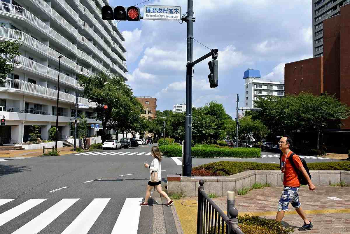
On Harimazaka street in Bunkyo Ward, Tokyo, a green area coexists alongside a broad vehicle road.
From cars to walking path
Tokyo Expressway, or KK Route, is a car-only road surrounding Ginza. The road was built in 1966 to promote reconstruction and reduce traffic congestion. People may think it is part of the metropolitan expressway network, but the two-kilometer-long roadway is not a toll road.
The company managing the road earns money to maintain the KK Route from tenants in commercial facilities under elevated railway tracks, such as Ginza Nine and Ginza Inz. After the Nihonbashi section of the metropolitan expressway, which is close to Ginza, is moved underground, the traffic volume on the road is expected to decline. For that reason, the road is scheduled to be closed in several years.
The Tokyo metropolitan government, which owns the land for the road, and others are considering retaining the place as a walking path with cafes, taking a hint from New York’s High Line, a park redeveloped from a disused elevated railway line. In May, the Tokyo government held the Ginza Sky Walk event and opened the KK Route to people as a walking path on a trial basis.
The attempt is abbreviated as “Gin-suka.” The “Gin-suka” culture of walking the road in Ginza is expected to take root just like the “Gin-Bura” culture of strolling in that popular commercial district.


Most Read
Popular articles in the past 24 hours
-
Power Outage Forces About 980 Passengers in Yokohama to Walk to T...
-

Masako Ikeda, Voice of Maetel in ‘Galaxy Express 999,' Dies at 87
-

Japan Defense Agency to Develop AI Intelligence Analysis System f...
-
Japan's TEPCO Releases Footage from Fukushima N-Plant Reactor
-
Japan's Sanyo Shinkansen Suspended Again; Between Okayama, Aioi S...
-

Japan Considering Taking Part in U.S. ‘Golden Dome’ Defense Syste...
-
46 Evacuated from UAE, Oman on Japanese Govt-chartered Flight
-
Government to Establish ‘Command Center’ for Developing Nuclear P...
Popular articles in the past week
-

Japan Figure Skating Legend Yuzuru Hanyu Is Proud Disaster Surviv...
-

Nippon Life Insurance's U.S. Arm Sues OpenAI Over Legal Assistanc...
-
Govt to Utilize ODA for Ensuring Economic Security; Securing Ener...
-
15 Measles Patients Confirmed in Tokyo in Past 6 Days; 1 May Have...
-
Massive Sewer Pipe Found Jutting Out of Highway in Osaka
-
Japan Govt to Tighten Requirements to Receive Permanent Residency...
-

Beckoning Cats Get Makeover to Fit Modern Lifestyles with Sleek D...
-
JR Tokai Breaks Ground on Yamanashi Maglev Station; Will Be Part ...
Popular articles in the past month
-
Producer Behind Pop Group XG Arrested for Cocaine Possession
-

Japan PM Takaichi’s Cabinet Resigns en Masse
-

Man Infected with Measles Reportedly Dined at Restaurant in Tokyo...
-

Videos Plagiarized, Reposted with False Subtitles Claiming ‘Ryuky...
-
Japan Figure Skating Legend Yuzuru Hanyu Is Proud Disaster Surviv...
-

iPS Treatments Pass Key Milestone, but Broader Applications Far f...
-

Sanae Takaichi Elected Prime Minister of Japan; Keeps All Cabinet...
-
Nepal Bus Crash Kills 19 People, Injures 25 Including One Japanes...
Top Articles in Society
-
Producer Behind Pop Group XG Arrested for Cocaine Possession
-
Man Infected with Measles Reportedly Dined at Restaurant in Tokyo Station
-
15 Measles Patients Confirmed in Tokyo in Past 6 Days; 1 May Have Come into Contact with Many in Shibuya
-

Bus Carrying 40 Passengers Catches Fire on Chuo Expressway; All Evacuate Safely
-

Ibaraki Pref.’s 1st Foreign Bus Driver Hired in Tsukuba
JN ACCESS RANKING
-
Producer Behind Pop Group XG Arrested for Cocaine Possession
-
Japan PM Takaichi’s Cabinet Resigns en Masse
-
Man Infected with Measles Reportedly Dined at Restaurant in Tokyo Station
-
Videos Plagiarized, Reposted with False Subtitles Claiming ‘Ryukyu Belongs to China’; Anti-China False Information Also Posted in Japan
-
Japan Figure Skating Legend Yuzuru Hanyu Is Proud Disaster Survivor and Gold Medalist, Vows to Continue Support Efforts