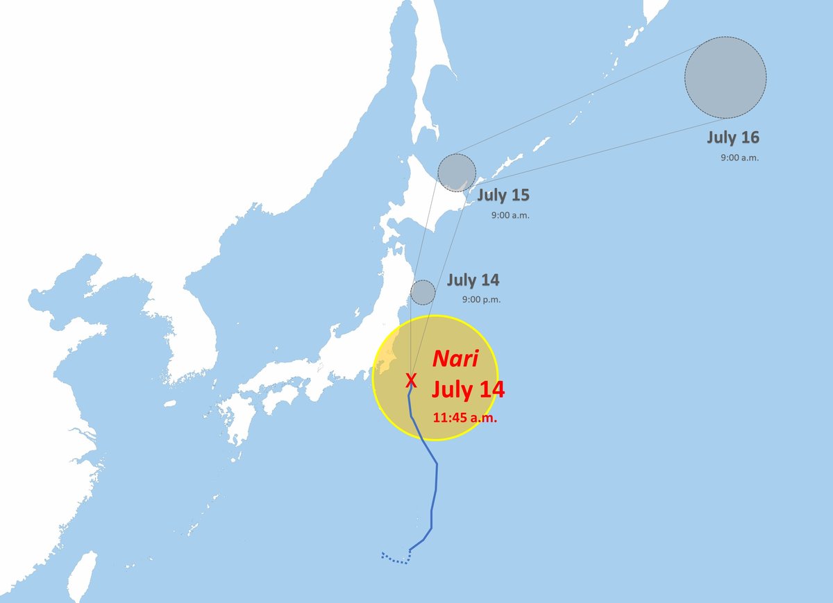
Typhoon Nari Passing East of Tokyo; Over 140 kph Gusts Expected By Evening
12:59 JST, July 14, 2025
Typhoon Nari, the fifth of the season, was passing east of the Kanto region early on Monday afternoon.
The typhoon had been moving north at 35 kph over the Pacific Ocean about 210 kilometers south-southeast of Choshi, Chiba Prefecture, at 9 a.m., according to the Japan Meteorological Agency.
It is expected to gain strength as it continues north toward the Sanriku coast. On Tuesday, it will travel past Hokkaido, after which it is expected to weaken into an extratropical cyclone.
Typhoon Nari is forecast to be traveling north at 50 kph about 70 kilometers southeast of Miyako, Iwate Prefecture, by 9 p.m. Monday. At that time, the agency forecasts that its central pressure will be 985 hectopascals and the maximum instantaneous wind speed will be 40 meters per second (144 kph).
At 9 a.m. on Tuesday, it is expected to be moving north-northeast at 55 kph, about 80 kilometers north-northeast of Abashiri, Hokkaido. It is forecast that the typhoon’s central pressure will have risen to 998 hectopascals and the maximum instantaneous wind speed will have dropped to 25 mps (90 kph).


Most Read
Popular articles in the past 24 hours
-

Japan Govt to Tighten Requirements to Receive Permanent Residency...
-

‘King Kazu’ Discusses His Connection to Fukushima
-

JR Tokai Breaks Ground on Yamanashi Maglev Station; Will Be Part ...
-

Medical Care at Home and Disasters: Ensure Systems to Provide Con...
-

Samurai Japan Holds First Practice in Miami; Team Will Play again...
-

CARTOON OF THE DAY (March 12)
-

White House Takes First Step toward Permanent Fix for Illegal Tar...
-

Metal Pipe That Protruded 13 Meters Above Ground in Osaka Sinks B...
Popular articles in the past week
-

Japan Figure Skating Legend Yuzuru Hanyu Is Proud Disaster Surviv...
-

Nippon Life Insurance's U.S. Arm Sues OpenAI Over Legal Assistanc...
-

Govt to Utilize ODA for Ensuring Economic Security; Securing Ener...
-
Massive Sewer Pipe Found Jutting Out of Highway in Osaka
-

Beckoning Cats Get Makeover to Fit Modern Lifestyles with Sleek D...
-

Japan Govt Survey Finds Just 10% of Workers Want Working Hours to...
-

Japan's 2nd Round of U.S. Investments May Be Worth Over $100 Bill...
-

Imperial Family Watches World Baseball Classic Game Against Austr...
Popular articles in the past month
-

Producer Behind Pop Group XG Arrested for Cocaine Possession
-

Japan PM Takaichi’s Cabinet Resigns en Masse
-

Man Infected with Measles Reportedly Dined at Restaurant in Tokyo...
-

Videos Plagiarized, Reposted with False Subtitles Claiming ‘Ryuky...
-
Japan Figure Skating Legend Yuzuru Hanyu Is Proud Disaster Surviv...
-

iPS Treatments Pass Key Milestone, but Broader Applications Far f...
-

Sanae Takaichi Elected Prime Minister of Japan; Keeps All Cabinet...
-

Nepal Bus Crash Kills 19 People, Injures 25 Including One Japanes...
Top Articles in Society
-
Producer Behind Pop Group XG Arrested for Cocaine Possession
-
Man Infected with Measles Reportedly Dined at Restaurant in Tokyo Station
-

Bus Carrying 40 Passengers Catches Fire on Chuo Expressway; All Evacuate Safely
-

Ibaraki Pref.’s 1st Foreign Bus Driver Hired in Tsukuba
-

Tokyo Skytree’s Elevator Stops, Trapping 20 People; All Rescued (Update 1)
JN ACCESS RANKING
-
Producer Behind Pop Group XG Arrested for Cocaine Possession
-
Japan PM Takaichi’s Cabinet Resigns en Masse
-
Man Infected with Measles Reportedly Dined at Restaurant in Tokyo Station
-
Videos Plagiarized, Reposted with False Subtitles Claiming ‘Ryukyu Belongs to China’; Anti-China False Information Also Posted in Japan
-
Japan Figure Skating Legend Yuzuru Hanyu Is Proud Disaster Survivor and Gold Medalist, Vows to Continue Support Efforts