Breakthrough AI System for Rapid Epicenter Detection and Tsunami Forecasting for Nankai Trough Earthquake
21:00 JST, January 4, 2025
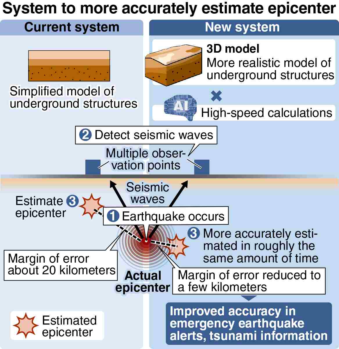
A team of researchers has developed a system using artificial intelligence to more accurately and rapidly estimate the focus of a possible Nankai Trough earthquake, reducing the margin of error from 20 kilometers to just a few kilometers.
The Japan Agency for Marine-Earth Science and Technology team hopes to use the estimate to determine tsunami height and arrival time, as well as which regions would experience the most severe shaking, thereby facilitating appropriate evacuation measures.
The system is expected to be made publicly available in the spring and put into practical use in the future.
A Nankai Trough earthquake refers to seismic events originating from the Nankai Trough, which extends from off the coast of Shizuoka Prefecture to off Miyazaki Prefecture. Earthquakes originating from the trough have historically occurred at intervals of 100 to 150 years.
According to the government’s earthquake research committee, there is a 70%-80% chance of such an earthquake occurring within the next 30 years. The potential impact is severe, and in a worst-case scenario, 231,000 people could be killed or go missing.
Right after an earthquake occurs, the Japan Meteorological Agency estimates the focus using seismic waves observed at various locations. This information is crucial for issuing emergency earthquake alerts and tsunami warnings. However, as seismic waves travel through complex underground structures, the models used for rapid estimation are simplified, leading to discrepancies.
For example, in August 2024, an earthquake that struck in the Hyuganada Sea off of Miyazaki Prefecture initially prompted an alert estimating the depth at 20 kilometers. However, it was later corrected to about 30 kilometers.
To address such inaccuracies, the team created a system that automatically estimates the focus using a 3D model reflecting the geological features of the Nankai Trough’s presumed earthquake zones. Making calculations using 3D models typically requires a significant amount of time, but the new system can make such calculations in seconds through the use of AI.
In simulations focusing on the Nankai Trough, the system had a significantly reduced margin of error compared to conventional methods, which was sometimes as much as about 20 kilometers. The calculations also took about five seconds. The time taken to issue an emergency earthquake alert is expected to remain close to the current average of about 20 seconds.
In order to put it into practical use, it is necessary to show how accurately the system can make such estimates as the severity of tremors and tsunami heights. The agency plans to allow researchers to use the system soon and have them test the system using data from previous earthquakes.
“I hope that, within a few years, private companies will use this system for tsunami forecasting,” said Ryoichiro Agata, a research fellow specializing in computational seismology and a member of the research team. “Ultimately, we aim for it to be integrated into the Japan Meteorological Agency’s emergency earthquake and tsunami warning systems.”
Related Tags
Top Articles in Society
-

JAL, ANA Cancel Flights During 3-day Holiday Weekend due to Blizzard
-
Record-Breaking Snow Cripples Public Transport in Hokkaido; 7,000 People Stay Overnight at New Chitose Airport
-

Australian Woman Dies After Mishap on Ski Lift in Nagano Prefecture
-

Foreign Snowboarder in Serious Condition After Hanging in Midair from Chairlift in Nagano Prefecture
-

Train Services in Tokyo Resume Following Power Outage That Suspended Yamanote, Keihin-Tohoku Lines (Update 4)
JN ACCESS RANKING
-
Univ. in Japan, Tokyo-Based Startup to Develop Satellite for Disaster Prevention Measures, Bears
-

JAL, ANA Cancel Flights During 3-day Holiday Weekend due to Blizzard
-

China Confirmed to Be Operating Drilling Vessel Near Japan-China Median Line
-

China Eyes Rare Earth Foothold in Malaysia to Maintain Dominance, Counter Japan, U.S.
-
Japan Institute to Use Domestic Commercial Optical Lattice Clock to Set Japan Standard Time


