Data Shows N. Korean Spy Satellite Controllable; Analysis Finds Steadily Orbiting over Japan, S. Korea
6:00 JST, March 12, 2024
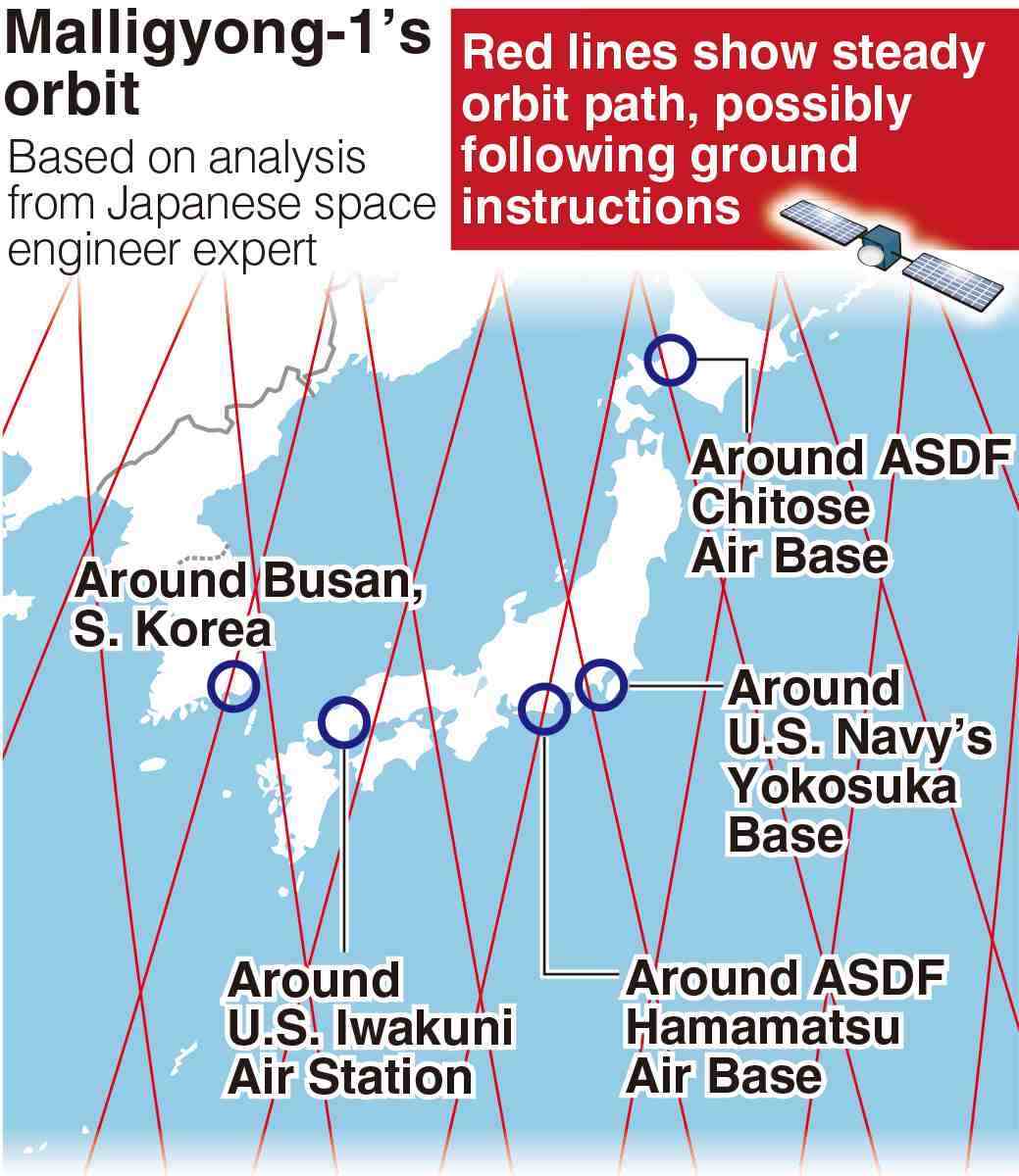
A military reconnaissance satellite launched by North Korea last November was found to have been repeatedly gaining altitude while steadily orbiting the Earth, according to a Japanese expert who analyzed available data from the U.S. military.
The Japanese government is also aware of the satellite’s movement, and are concerned over the possibility that it has been able to follow instructions from the ground.
The satellite, the Malligyong-1, has been registered by the U.S. Space Force on satellite tracking site Space-Track, which publicly releases daily tracking data of satellites and space debris in orbit.
At the request of The Yomiuri Shimbun, the space engineering expert examined data from late November to early March and found that the satellite had gained altitude rapidly at least five times in late February.
Malligyong-1’s average altitude immediately after launch was about 502 kilometers, and it has gradually lowered since then due to what is thought to have been slight air resistance in space. However, the satellite ascended by about 4 kilometers in late February, returning to almost the same orbit as it was immediately after launch.
Defense Minister Minoru Kihara admitted in November that the North Korean satellite was orbiting the Earth and said that careful analysis was needed to determine whether the satellite was following its intended path and fulfilling its functions.
The expert, speaking on condition of anonymity, said: “The altitude has changed rapidly in a short period of time, and it is reasonable to assume that the orbit was artificially adjusted by sending commands from the ground.”
Several Japanese government officials told The Yomiuri Shimbun that they believed the satellite was under Pyongyang’s control.
The analysis shows that the Malligyong-1 passed over the vicinities of the U.S. Iwakuni Air Station in Yamaguchi Prefecture and the South Korean city of Busan, where a military port exists. The analysis also found the satellite could observe the same spot on the ground about once every five days.
North Korea has not released any images, but it claims that the satellite has taken photos of a U.S. atomic-powered aircraft carrier docked in Busan and the U.S. Andersen Air Force Base in Guam.
The satellite’s image capture abilities are still unknown among other capabilities. It is possible that Pyongyang is advancing its technology with help from Moscow, so the Japanese government is working to speed up its analysis by working with Washington and Seoul.

Most Read
Popular articles in the past 24 hours
-
Man Accused of Making Woman Drink 32 Shots of Tequila, Resulting ...
-
Japanese Shipping Giants Halt Strait of Hormuz Transit as Iran Co...
-

U.S. Launches Attacks on Iran: Avoid Escalation of Conflict by An...
-
Japan Police Told to Boost Security, Vigilance Around U.S., Israe...
-

Japan Shares and Yen Fall, Jgbs Rise as Iran Strikes Continue
-

Takaichi: Japan Striving to Ensure Safety of Japanese Nationals; ...
-

Japan Traditional Puppet Performance Held at Onsen Resort in Shiz...
-

Sawtooth Roof Factory Stands as Monument to Ashikaga Textile Hist...
Popular articles in the past week
-

Milano Cortina 2026: Japanese Gold Medalist Figure Skater Miura S...
-

Tokyo Spends Big on Children, Wins Over Parents
-

McDonald's Japan Raises Prices; Big Mac to Cost ¥500, Double Chee...
-

Japan’s Miura, Kihara Announce Withdrawal from Figure Skating Wor...
-

Exhibition Featuring Yoshiharu Tsuge’s Manga World Underway in Ch...
-

Yokohama to Test Out Renewable-Powered Offshore Floating Data Cen...
-

BOJ Keeping Eye on Economy and Takaichi's ‘Proactive Fiscal Polic...
-

20 Trapped in Tokyo Skytree Lift, Rescued 5½ Hours Later
Popular articles in the past month
-
Producer Behind Pop Group XG Arrested for Cocaine Possession
-

Japan PM Takaichi’s Cabinet Resigns en Masse
-

Man Infected with Measles Reportedly Dined at Restaurant in Tokyo...
-

Israeli Ambassador to Japan Speaks about Japan’s Role in the Reco...
-

Videos Plagiarized, Reposted with False Subtitles Claiming ‘Ryuky...
-

Man Infected with Measles May Have Come in Contact with Many Peop...
-

Prudential Life Insurance Plans to Fully Compensate for Damages C...
-
Woman with Measles Visited Hospital in Tokyo Multiple Times Befor...
Top Articles in Politics
-
Japan PM Takaichi’s Cabinet Resigns en Masse
-

Sanae Takaichi Elected Prime Minister of Japan; Keeps All Cabinet Appointees from Previous Term
-

Japan’s Govt to Submit Road Map for Growth Strategy in March, PM Takaichi to Announce in Upcoming Policy Speech
-

LDP Wins Historic Landslide Victory
-

LDP Wins Landslide Victory, Secures Single-party Majority; Ruling Coalition with JIP Poised to Secure Over 300 seats (UPDATE 1)
JN ACCESS RANKING
-
Producer Behind Pop Group XG Arrested for Cocaine Possession
-
Japan PM Takaichi’s Cabinet Resigns en Masse
-
Man Infected with Measles Reportedly Dined at Restaurant in Tokyo Station
-
Israeli Ambassador to Japan Speaks about Japan’s Role in the Reconstruction of Gaza
-
Videos Plagiarized, Reposted with False Subtitles Claiming ‘Ryukyu Belongs to China’; Anti-China False Information Also Posted in Japan