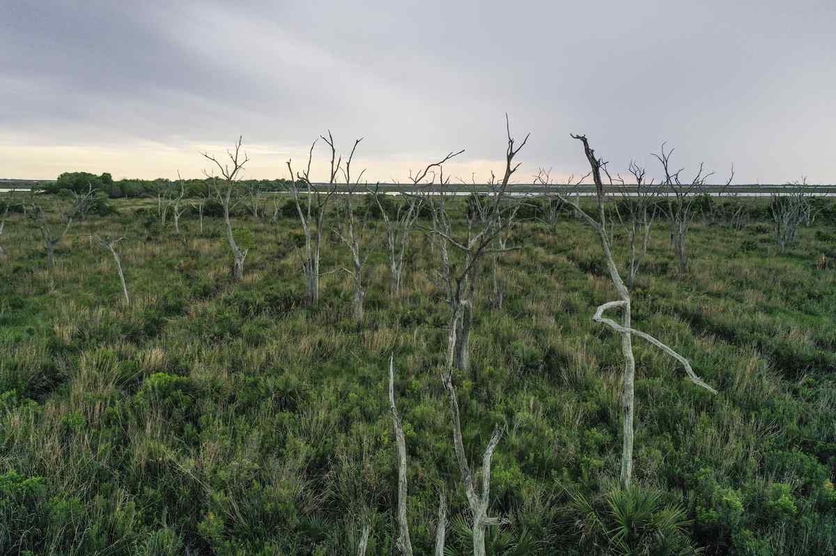
A view of a live oak “ghost forest” in Yscloskey, Louisiana, in March 2023
15:45 JST, January 31, 2026
From above, there’s no mistaking the loss.
More than 11 million points pepper a map of the East Coast, each representing a once-living tree, in a trail of mortality stretching from South Carolina to Maine.
“We can pretty confidently say we can count basically every dead tree,” said Xi Yang, a University of Virginia professor and one of a team of researchers whose recent work has helped shed new light on the proliferation of what are known as “ghost forests.”
These haunting landscapes, with their unmistakable gray, barren tree trunks rising like sentinels, offer one of the most startling and recognizable signals of a changing climate.
While many researchers have helped to map out where ghost forests are appearing in different states, Yang said, “We actually haven’t known the full extent. … Now we can see that the extent is much bigger than maybe we expected.”
As sea levels rise, droughts grow more prolonged and storms become more intense, saltier water has increasingly made its way into these coastal woodlands from surrounding water bodies. It’s also finding its way into places farther inland, often along drainage ditches and agricultural irrigation canals built long ago.
In some places, forests that once teemed with maple, sweet gum, bald cypress and stately pines have given way to shrubland. Some have already begun to surrender entirely to the advance of saltwater and flooding.
It is a phenomenon that has been increasingly studied by scientists in recent years, who have documented the existence of ghost forests in places throughout the Gulf and Atlantic coasts. Even though their mere presence is not new, researchers have raced to better understand the processes that are hastening the death of such forests, what the changes mean for wildlife and plants, and the potential consequences should huge stores of carbon that lie beneath these landscapes get released back into the atmosphere.
The recent work by a team at the University of Virginia, along with colleagues at several other institutions, including Duke University, used a novel approach to show in a comprehensive way how the spread of ghost forests is likely to be more extensive than previously known.
The group used high-resolution aerial imagery, coupled with a computer model designed to spot the attributes of tree mortality, to identify 11,895,443 dead trees across coastal forests in 11 states. Their research was published in December in the journal Nature Sustainability.
The innovative approach “provides a much more detailed view of the status of coastal forests,” said Marcelo Ardón, an ecologist at North Carolina State University who was not involved in the study but who also has done in-depth research on the complex changes unfolding in coastal forests.
“By applying a deep-learning model to high-resolution photos, the authors were able to detect more areas with high tree mortality than had been picked up previously,” Ardón said.
Not all of the dead trees that the images detected are the product of saltwater intrusion, the authors are quick to point out. Drought, pests and storms also can take their toll. But at the same time, the group wrote, it is clear that climate-stressed forests are vast.
“Our analysis reveals disproportionate and pervasive tree mortality in many previously unrecognized ghost forest hotspots,” the authors wrote, saying that 6 million of the dead trees they tallied were concentrated in low-lying forests more exposed to rising seas and salinization. “These findings highlight the alarming decline in coastal forests and the need for strategic long-term planning to preserve the critical services that coastal ecosystems provide.”
The results of the new mapping, the researchers say, matter largely because of what is at stake. The coastal forests most at risk from sea-level rise and saltwater intrusion sequester massive amounts of carbon. They mitigate the impact of storms, play a key role in water quality for nearby communities and provide habitat for a range of species.
Importantly, Ardón said, the study’s authors “made their maps publicly available, so managers of conservation areas or forestry plantations can use the maps to identify places where trees might be suffering from high mortality due to salinity or flooding.”
In one intriguing wrinkle, the recent study also found that roads, levees and other human-made structures often acted as a barrier to advancing saltwater, significantly reducing mortality of nearby trees. “On a regional scale, roads and levees have slowed down the rate of coastal forest die-off,” the authors wrote.
Still, plenty of questions remain. While the UVa.-led study presented “the first large-scale and high-resolution ghost forest map, aggregated directly from individual dead trees,” other researchers continue to explore the reasons behind their spread and what actions humans might take to slow the death of such forests.
Despite the novel methods on display, the study’s authors did not rely solely on aerial imagery and computer models for their findings.
“There was a lot of ground truth,” Yang said.
Namely, on one trip in the fall, scientists traded computer screens for rubber boots, wading into forests in North Carolina’s Albemarle Peninsula to verify some of what the aerial imagery had found. As it turns out, the approach proved very accurate. While the images from above didn’t offer reasons for why the trees had died, they had pinpointed dying clusters that were not easily accessible and might otherwise have gone unnoticed.
“I was there,” Yang joked. “There were a lot of mosquitoes.”


Most Read
Popular articles in the past 24 hours
-

Milano Cortina 2026: Sakamoto Serves as Flag Bearer; Japan Earns ...
-

Milano Cortina 2026: There Were Cheers across the Country, after ...
-

Emperor Turns 66 Ahead of Disaster Milestones
-

Luna Sea Drummer Shinya Dies at 56; Powerful Drummer Behind ‘Desi...
-

Milano Cortina 2026: ‘Magical’ Italian Games Close wi...
-

Milano Cortina 2026: Riku-Ryu Duo Stick Together During Closing C...
-

1.2 Mil. Rapeseed Flowers Attract Cute Birds, People in Aichi Pre...
-

Mexican Army Kills Leader of Powerful Jalisco New Generation Cart...
Popular articles in the past week
-

Japan PM Takaichi’s Cabinet Resigns en Masse
-

Man Infected with Measles Reportedly Dined at Restaurant in Tokyo...
-

Sanae Takaichi Elected Prime Minister of Japan; Keeps All Cabinet...
-

Japan's Govt to Submit Road Map for Growth Strategy in March, PM ...
-

Bus Carrying 40 Passengers Catches Fire on Chuo Expressway; All E...
-

Milano Cortina 2026: Figure Skaters Riku Miura, Ryuichi Kihara Pa...
-

U.S. Firm to Build Training Hub in Fukushima N-plant for Debris R...
-

Japan, U.S. Name 3 Inaugural Investment Projects; Reached Agreeme...
Popular articles in the past month
-
Japan PM Takaichi’s Cabinet Resigns en Masse
-

Japan Institute to Use Domestic Commercial Optical Lattice Clock ...
-

Israeli Ambassador to Japan Speaks about Japan’s Role in the Reco...
-
Man Infected with Measles Reportedly Dined at Restaurant in Tokyo...
-

Videos Plagiarized, Reposted with False Subtitles Claiming ‘Ryuky...
-

Man Infected with Measles May Have Come in Contact with Many Peop...
-

Prudential Life Insurance Plans to Fully Compensate for Damages C...
-

Woman with Measles Visited Hospital in Tokyo Multiple Times Befor...
Top Articles in News Services
-

Survey Shows False Election Info Perceived as True
-

Prudential Life Expected to Face Inspection over Fraud
-

Hong Kong Ex-Publisher Jimmy Lai’s Sentence Raises International Outcry as China Defends It
-

Japan’s Nikkei Stock Average Touches 58,000 as Yen, Jgbs Rally on Election Fallout (UPDATE 1)
-
Japan’s Nikkei Stock Average Falls as US-Iran Tensions Unsettle Investors (UPDATE 1)
JN ACCESS RANKING
-
Japan PM Takaichi’s Cabinet Resigns en Masse
-
Japan Institute to Use Domestic Commercial Optical Lattice Clock to Set Japan Standard Time
-
Israeli Ambassador to Japan Speaks about Japan’s Role in the Reconstruction of Gaza
-
Man Infected with Measles Reportedly Dined at Restaurant in Tokyo Station
-
Videos Plagiarized, Reposted with False Subtitles Claiming ‘Ryukyu Belongs to China’; Anti-China False Information Also Posted in Japan