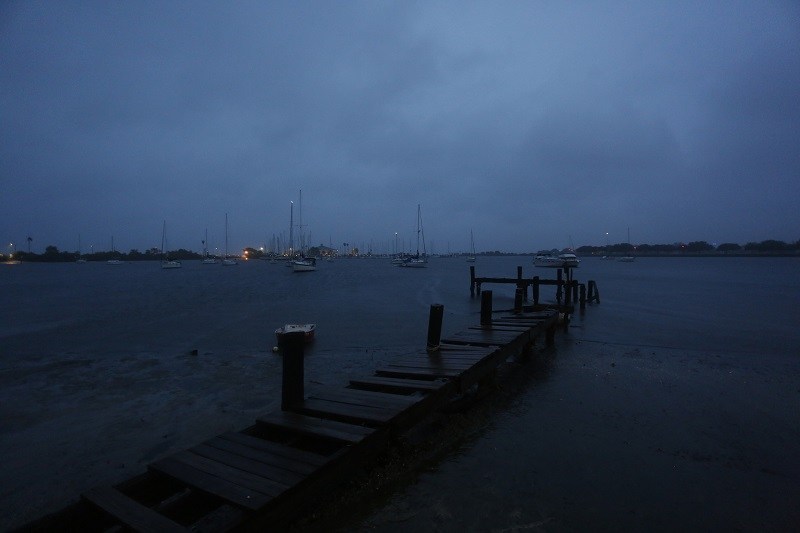
Clouds above Tampa Bay at the Davis Islands Yacht Club Sept. 28.
12:37 JST, September 29, 2022
TAMPA – One of the strongest hurricanes ever to strike the United States slammed into southwest Florida on Wednesday afternoon with Category 4-level winds, inundating coastal communities and threatening to besiege the entire peninsula with devastating gusts and flooding as the storm slowly swirled east.
Packing peak winds of 150 mph, Hurricane Ian made landfall just after 3 p.m. near the barrier island of Cayo Costa, west of Cape Coral and Fort Myers, hours after a severe storm surge began turning roads into rivers. After rapidly intensifying overnight Tuesday, Ian tied for the fifth-strongest hurricane to hit the United States, and Gov. Ron DeSantis (R) said he had asked President Joe Biden to free up federal assistance by declaring a major disaster declaration for all 67 Florida counties.
The hurricane was “a ferocious storm coming in, very hazardous, very ominous,” DeSantis said Wednesday evening. He warned: “Once the storm goes, once there’s apparent calm, there are still plenty of hazards out there.”
The breadth of Hurricane Ian’s damage to life and property remained unclear Wednesday evening as strong winds prevented first responders in the most-flooded communities from carrying out rescues. Post-storm dangers – such as downed power lines, standing water and misused generators – killed dozens of Floridians after Hurricane Irma in 2017, and they again would present grave danger following Ian, DeSantis said.
Hurricane Ian, which the National Hurricane Center referred to as “extremely dangerous,” shoved water over thresholds, bent some palm trees and plucked others from the ground, and overturned small airplanes with the ease of a giant. By early evening, the storm had knocked out power for more than 1 million Floridians, further darkening a famously sunny state trapped under ominous steel-hued skies.
Forecasts that warned of 12 to 18 feet of storm surge appeared to come to pass around Fort Myers Beach, a barrier island taking the brunt of Hurricane Ian’s strongest winds. Boardwalk cameras and videos captured from high-rises there showed pounding waves carrying large amounts of debris and, in at least one video, the roof of a building. By midafternoon, storm surge had caused water levels in the city of Naples to reach more than six feet above normal high tide, NOAA said. Social media videos showed residents swimming inside their homes.
The National Weather Service, issuing a midafternoon extreme wind warning for a stretch of coastline around Cape Coral, implored residents to treat the impending gusts “as if a tornado was approaching.” The National Hurricane Center, meanwhile, issued hurricane warnings for Florida’s Atlantic coast. Even before landfall, emergency preparedness officials were warning of a “very long road.”
As the hurricane roared toward a stretch of Southwest Florida coastal counties, the stream of evacuations ordered up and down the Gulf Coast slowed, with officials pivoting to the opposite message: Stay put.
“If you are in any of those counties, it is no longer possible to safely evacuate. It’s time to hunker down and prepare for the storm,” DeSantis said Wednesday morning. “Do what you need to do to stay safe. If you are where that storm is approaching, you’re already in hazardous conditions. It’s going to get a lot worse very quickly. So please hunker down.”

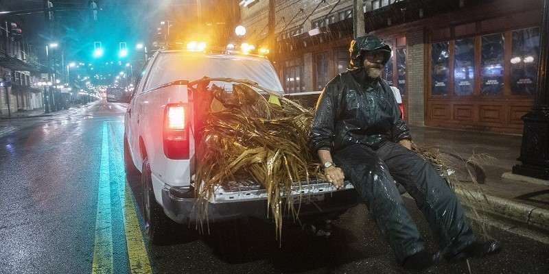
In the Ybor City neighborhood of Tampa early on Sept. 28, Lew Hendrix collects palm branches blown down by the outer bands of Hurricane Ian.
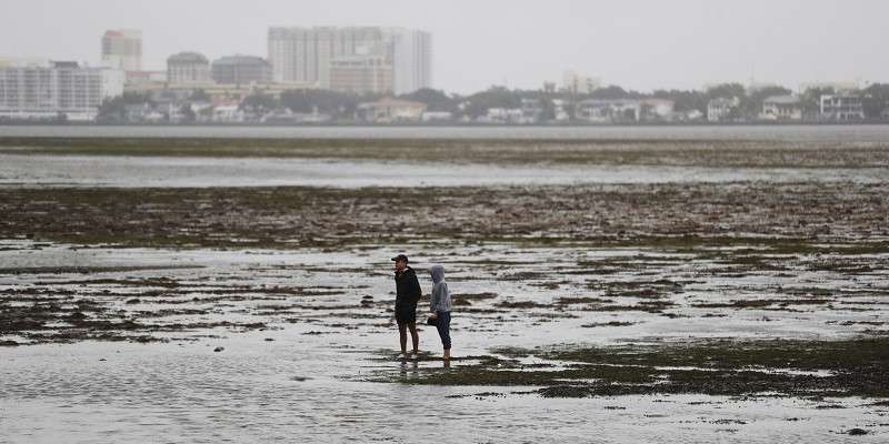
People in the Tampa Bay area, who had spent days dreading storm surge projected to cause unprecedented destruction in a dense and vulnerable region, breathed a sigh of relief as Ian shifted Tuesday and directed its fury farther south. Seawater receded from the Tampa shoreline Wednesday morning as Ian grew over- the Gulf of Mexico, pushing water out and eerily emptying the bay.
For locals who had spent the previous days stocking up on supplies and weatherproofing their homes, the barren bay presented a final, if risky, chance to frolic before the storm drove them inside.
Cars lined up along Bayshore Boulevard, a waterfront road in south Tampa, and people braved increasingly strong winds and rain to snap selfies, walk dogs and tromp across the bay. Authorities warned against the bayside gathering, with Tampa police tweeting that “now is NOT the time for sightseeing” and urging revelers to go home.
Siblings Julia and Charlie Allen drove up from Clair-Mel City, a community southeast of downtown Tampa, for what “felt like a once-in-a-lifetime opportunity.”
“We had to come see the bay without water,” Julia said. “We’re so used to seeing it full.”
But the bay water was expected to forcefully return, and Mayor Jane Castor warned that the city was “not out of danger,” with 18 to 20 inches of rain and high winds expected.
In Tampa’s Ybor City neighborhood, 62-year-old Don Hughes said he had no choice but to stay where he was – flopped on a foldable chair, trying to stay dry under a Burger King awning. Hughes, who has suffered three heart attacks and said he was made homeless after his rent skyrocketed 18 months ago, said he planned to ride out the hurricane huddled next to the building for as long as he could.
“I’m worried about it, but what can I do?” Hughes asked as he pointed to a canvas bag. “This is all I got right there. … I am just sitting here waiting it out, hungry.”
Kevin Guthrie, the director of the Florida Division of Emergency Management, told reporters Wednesday evening that 42,000 “restoration personnel” and 10,000 first responders were ready to deploy in the affected areas by ground, air and sea.
As the storm moves away from the shore, it could cause an additional life-threatening hazard: inland flooding.
Federal Emergency Management Agency Administrator Deanne Criswell and National Weather Service Director Ken Graham said Wednesday that flooding was among their top safety concerns. Water has accounted for the vast majority of all deaths during tropical cyclones that have made landfall in the United States: Eighty-three percent of fatalities during almost all storms from 2016 to 2018 were water-related, according to NOAA. Most were from inland flooding; only 4 percent were from storm surge, the agency said.
Hurricane Ian is expected to bring record-setting rainfall to Central Florida in the coming days, causing potentially catastrophic flooding in a region dotted with thousands of natural lakes, rivers and artificial ponds.
“Localized amounts of rain may reach 24 inches, and that would be historic in such a short time,” said Kole Fehling, a meteorologist with the National Weather Service in Melbourne, Fla. “Leading up to the hurricane, we had a lot of heavy rain, so that will make flooding an even greater issue.”
Jacksonville, on the Atlantic Coast in northeast Florida, was also bracing for impact. Two days ago, the city – which in 2017 suffered one of its worst floods in more than a century when Hurricane Irma dumped more than 2 trillion gallons of water in the area – thought it might be largely spared. Hurricane Ian then appeared to be heading to the Panhandle.
But now Jacksonville is in Ian’s path. Ian is expected to be a tropical storm by the time it hits Jacksonville late Thursday, but it will still have hurricane-strength gusts. The area remains under a storm-surge warning.
“In large hurricanes, there’s really only so many things you can do, and once the system is overwhelmed, which is going to be the case with this storm, there’s not a lot left to do,” said Ann Shortelle, who led the St. Johns River Water Management District when Irma hit.
Although Key West was spared the worst of Hurricane Ian, the massive storm brought unexpected flooding to parts of the island, prompting some to make last-minute evacuations during the storm. Among those unexpectedly uprooted were 61 Navy personnel and their families, who were living in low-lying parts of Naval Air Station Key West.
Dylon Estevez, 29, a lifelong Key West resident, called the sudden flooding in his apartment Tuesday night “almost like shock and awe.” At first, it was toe deep. Then shin deep. When it reached his knees around 10:30 p.m., he turned off the power and grabbed a pair of sneakers floating in the water. His roommate carried their dog, Rookie. In the street, the water was waist deep and churning.
“I don’t think anyone expected it,” Estevez said. “It just happened so quickly that it came over within the last few hours, and then by that time it was too late.” He returned to his street Wednesday morning, hoping to assess the damage, but he still could not get to his place. The water was too high.
Ian was the latest storm to undergo “rapid intensification,” which scientists say is occurring more often because of human-caused climate change. When Floridians went to bed Tuesday night, the hurricane was a Category 3 storm with 120 mph winds. By morning, it was approaching the coast at a roaring 155 mph – just shy of a Category 5 storm. The storm continued to intensify as it made landfall.
Rapid intensification, defined as wind speeds increasing at least 35 mph within 24 hours, is partially fueled by warmer sea-surface temperatures, which have globally increased 1.1 degrees Fahrenheit over the past century. Such intensification usually occurs in major hurricanes, ranking as Category 3 or above. A warmer atmosphere, which can “hold” more water vapor, is also increasing the amount of rainfall during larger storms.
Satellite data shows sea surface temperatures around the Florida coast are slightly warmer than the long-term average. Temperatures are approaching 86 degrees; anything above 82 degrees can sustain and intensify hurricanes.

Water in Hillsborough Bay in Tampa receded drastically as Hurricane Ian headed for the Florida Gulf Coast on Wednesday.
Top Articles in News Services
-

Survey Shows False Election Info Perceived as True
-

Prudential Life Expected to Face Inspection over Fraud
-

Hong Kong Ex-Publisher Jimmy Lai’s Sentence Raises International Outcry as China Defends It
-

Japan’s Nikkei Stock Average Touches 58,000 as Yen, Jgbs Rally on Election Fallout (UPDATE 1)
-

Japan’s Nikkei Stock Average Falls as US-Iran Tensions Unsettle Investors (UPDATE 1)
JN ACCESS RANKING
-

Japan PM Takaichi’s Cabinet Resigns en Masse
-

Japan Institute to Use Domestic Commercial Optical Lattice Clock to Set Japan Standard Time
-

Israeli Ambassador to Japan Speaks about Japan’s Role in the Reconstruction of Gaza
-

Man Infected with Measles Reportedly Dined at Restaurant in Tokyo Station
-

Videos Plagiarized, Reposted with False Subtitles Claiming ‘Ryukyu Belongs to China’; Anti-China False Information Also Posted in Japan


