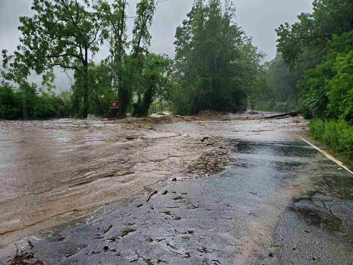
Numerous motorists were stranded by flooding Sunday in Rockland County, the New York State Police said.
12:34 JST, July 11, 2023
Intense rainstorms dropped more than a month’s worth of precipitation in parts of New York’s Hudson Valley and southern Vermont, causing historic flooding across New England that killed at least one person, trapped dozens of others and washed away major roads between Sunday afternoon and Monday.
Heavy rainfall was forecast to continue across the region into Monday night, with heightened flash flooding risks extending into New Hampshire and Maine. For parts of the Northeast, flooding was the worst seen since Hurricane Ida in 2021, if not since Hurricane Irene killed dozens of people in 2011.
The storms were the latest to underscore rising threats of extreme rainfall as the planet warms, allowing the air to carry more moisture. First Street Foundation data analyzed by The Washington Post shows that, in many of the areas being inundated, flood risks have grown many times greater than historic data suggests.
In Orange County, N.Y., for example, where the U.S. Army Garrison at the U.S. Military Academy reported washed-out roads Sunday after more than eight inches of rainfall, what was once a 100-year storm can now be expected to occur once every 19 years, or about five times as often. In some counties in Vermont, extreme rain events could happen twice as often.
Virtually all of Vermont was under flash flood warnings Monday afternoon. A flash flood emergency, the highest level of alert, was in effect for the southern part of the state, including Rutland and the popular ski resort towns of Killington and Ludlow as rain fell at rates of as much as 1.5 inches per hour. Half-a-foot fell in the early-morning hours, the National Weather Service said.
“This is an all-hands-on-deck response,” Vermont Gov. Phil Scott (R) said at a news briefing, adding he would be requesting a federal disaster declaration from the White House. “We have not seen rainfall like this since [Hurricane] Irene, and in some places it will surpass even that.”
“This may just be the start of what we will see,” Scott added, noting heavy rain is likely to persist for hours.
State emergency management officials said they are investigating unconfirmed reports that one person was swept away Monday morning in Londonderry, in the central portion of the state. The incident was reported by two swift water rescue teams about 7:30 a.m., but officials are struggling to reach the area.
Teams used boats to rescue 19 people from their homes, and helped another two dozen to evacuate as flooding devastated the Londonderry and Weston areas, Mike Cannon, of the Vermont Urban Search and Rescue Team, said at a news briefing. He said both communities were “inaccessible” by midday Monday.
Flooding closed about two-dozen roads across the state, and emergency crews made multiple rescues, according to the Vermont State Police. Ten people were rescued from high water at a campsite near Andover, the Weather Service reported.
Authorities urged residents to avoid flooded roads and to stay abreast of weather news across New England on Monday. Widespread rainfall totaling 2 to 5 inches was forecast across the region, with some spots expected to receive seven or more inches. Some places had already received 6 to 8 inches of rain by midmorning.
“With saturated soil and elevated river levels from recent rainfall, widespread significant to potentially catastrophic flash flooding is expected today and tonight,” Weather Service forecasters in Burlington, Vt., wrote. “Widespread area and river flooding will persist into Tuesday.”
Extreme rainfall destroys roads, kills one in New York
In New York, the Hudson Valley was the most affected after torrential rains were blamed for one storm-related death in the town of Highlands, state Sen. James Skoufis (D) said in an email, adding that authorities were working to see whether there were more casualties, as “vital infrastructure and homes were washed away.”
In some cases, Skoufis said, entire roads were destroyed by the flooding. Orange and Rockland counties received 5 to 8 inches of rain, the Weather Service said.
Calling the floods “life-threatening,” New York Gov. Kathy Hochul (D) issued a state of emergency for Orange and Ontario counties late Sunday. Nearly 13,000 residents lost power because of the storms in Orange County, she said.
In a tweet, Hochul emphasized the role climate change plays in increasingly severe weather: “Make no mistake: This is our new normal,” she wrote. “We are the first generation to feel the impacts of climate change & the last generation with a shot at doing anything about it.”
Flash flood warnings were issued for New York City overnight Sunday, with officials asking residents of basement apartments to move to a higher floor and for all New Yorkers to stay off roads.
The last severe deluge and flooding in New York City were the result of Hurricane Ida in 2021 and was linked to 44 deaths in New York, New Jersey, Pennsylvania and Connecticut, 16 of them in New York City. The city’s inadequate infrastructure and drainage system were major factors in its vulnerability to flooding, authorities acknowledged at the time.
This weekend’s severe weather also affected travel services. Amtrak said it temporarily halted services between New York City and Albany, while Newark and LaGuardia airports reported flight disruptions.
“If you do not need to be on the road, stay off the road. We have a number of emergencies,” Orange County Executive Steve Neuhaus warned residents in a Facebook update from the Highland Falls area in the southern part of the county.
Numerous roads were flooded, and mudslides were reported by the emergency services office of the town of Cornwall, also in Orange County. “Travel is impossible,” the office said on Facebook, advising residents to move to higher ground.
State troopers were helping stranded motorists on the Palisades Interstate Parkway in Rockland County, said Steven Nevel, a spokesman for the New York State Police, who reported a “terrible” situation, with roads crumbling. Images shared by the state police showed submerged vehicles on the highway and damaged roads.
The William Moreau Popolopen Bridge in Highland Falls was not passable, and multiple roads remained closed.
Hochul told reporters that the state was possibly staring at back-to-back days of flooding.
“My biggest concern,” she said, “is the fact that most people’s lives that are lost during a flood event occur because they’re in their vehicles – not in their homes, but in their vehicles.”
Craig Ceecee, a meteorologist and doctoral student at Mississippi State University, described the extremely heavy rain in the lower Hudson Valley as a “once-in-1,000 year rainfall event” in a tweet.
Another meteorologist said that the Hudson Valley was hit by a month’s worth of rain in just a few hours.
“The #Hudson Valley’s warming climate is increasing the risk for heavy rainfall,” tweeted Ben Noll, a New Zealand-based meteorologist who is from the Hudson Valley, adding that a warmer atmosphere makes heavier rainfall events more probable. The trend can contribute to “increased risk for extreme rainfall rates that can cause flash flooding, too,” he wrote.
Top Articles in News Services
-

Survey Shows False Election Info Perceived as True
-

Hong Kong Ex-Publisher Jimmy Lai’s Sentence Raises International Outcry as China Defends It
-

Japan’s Nikkei Stock Average Touches 58,000 as Yen, Jgbs Rally on Election Fallout (UPDATE 1)
-

Japan’s Nikkei Stock Average Falls as US-Iran Tensions Unsettle Investors (UPDATE 1)
-

Trump Names Former Federal Reserve Governor Warsh as the Next Fed Chair, Replacing Powell
JN ACCESS RANKING
-

Producer Behind Pop Group XG Arrested for Cocaine Possession
-

Japan PM Takaichi’s Cabinet Resigns en Masse
-

Man Infected with Measles Reportedly Dined at Restaurant in Tokyo Station
-

Israeli Ambassador to Japan Speaks about Japan’s Role in the Reconstruction of Gaza
-

Videos Plagiarized, Reposted with False Subtitles Claiming ‘Ryukyu Belongs to China’; Anti-China False Information Also Posted in Japan


