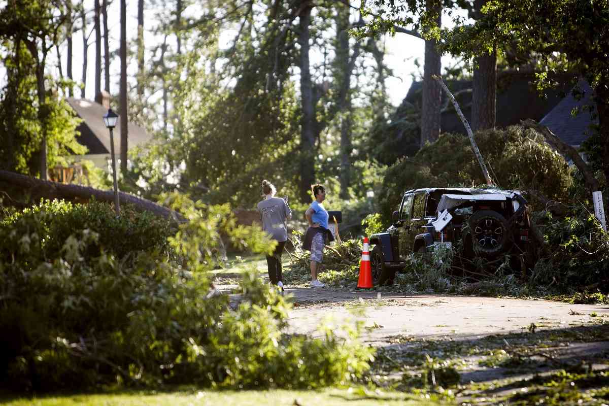
People on Monday walk by trees and a car damaged by a tornado that hit Virginia Beach.
12:20 JST, May 2, 2023
A trio of tornadoes – two in Florida and one in Virginia – touched down in the past three days, causing serious damage in some places and even prompting the city of Virginia Beach to declare a local state of emergency.
Two of the tornadoes were strong, with winds of 130 mph or greater, while a third touched down only fleetingly and without warning, still causing damage. In Florida, vehicles were lofted and tossed like toys, while in Virginia, homes were destroyed.
The back-to-back-to-back twisters accompanied a strong low-pressure system that worked its way up the East Coast over the weekend. For the remainder of the workweek, continued cool and unsettled conditions are likely for the eastern United States.
Virginia Beach tornado on Sunday
On Sunday, low pressure was moving up the Eastern Seaboard. Most major cities were on the western side of the low, which meant heavy rainfall and cool northerly winds. But to the east of the counterclockwise-spinning low, a narrow sliver of warmth and moisture clipped the eastern Carolinas and southeastern Virginia.
That was just enough to juice up the power in the atmosphere, allowing thunderstorms to grow vertically into a sheared environment. The jet stream was also working overhead, bolstering wind shear. Within that “warm sector,” a thunderstorm formed that was able to produce a tornado just west of Virginia Beach.
The National Weather Service confirmed Monday morning that an EF3 tornado on the Enhanced Fujita Scale touched down Sunday in Great Neck. The agency said a survey was still in progress and it would release additional details about the tornado later. The tornado appears to be the most intense one to hit Virginia Beach since at least 1950, according to an online tracker.
Palm Beach tornado on Saturday
Just 24 hours earlier, another powerful tornado tore through Florida’s Palm Beach County. It formed without a tornado warning, though one was alerted two minutes after it was estimated that the tornado had already touched down.
Strong to severe thunderstorms fired along the afternoon sea breeze. Meteorologists at the local Weather Service office specifically warned of potential spin-ups along boundaries, writing that “a few funnel clouds or brief tornadic/waterspout activity is also possible with sea breeze and outflow boundary interactions.”
That was exactly what happened. The agency noted a cell merger, or the combination of two thunderstorm cells, near the Turnpike and I-95 in Palm Beach Gardens. The merger then further strengthened rotationally upon latching on to the sea breeze.
The tornado touched down at 5:10 p.m. near the highway, then breezed past the Palm Beach Gardens Medical Center before making a trek up U.S. Route 1. Eventually the tornado lifted before reaching Juno Beach.
Winds were estimated at 130 mph, placing the tornado at the far upper end of EF2 strength. Numerous videos of the tornado emerged on social media, including one that captured a vehicle stopped in an intersection being lifted by the twister.
“We’d had just a period of relatively cold temperatures aloft,” said Nick Carr, a meteorologist at the Weather Service office in Miami. Carr, among many others, was surprised by the strength of the sea breeze tornado – since such tornadoes are usually weak and quick-hitting. Carr also explained that strong winds aloft were contributing to shear, or a change of wind speed and/or direction with height.
“There was relatively strong deep-layer shear with the subtropical jet [stream] and enhanced mid-level westerlies overhead,” he said. “Most of the low-level helicity [spin] was rooted on the sea breeze. But why we had a high-end EF2 rather than a quick EF0, we couldn’t exactly tell you. That’s rare.”
Surprisingly, Sunday’s setup featured more classic tornado ingredients, and yet twisters failed to materialize.
“Sunday was probably our best low-level wind day, and we didn’t see any,” he said. “The two more marginal days are the ones where we saw tornadoes.”
Florida has had an extended period of active severe weather of late. The Sunshine State logged three consecutive days with hail the size of tennis balls or larger. On April 24, Thonotosossa, about 30 miles east-northeast of Tampa along Interstate 4, received hail up to 3 inches in diameter, the size of a baseball. Hail that size also fell Tuesday in Mascotte and near Four Corners in Lake County, one county away from Orlando. By Wednesday, tennis-ball-size hail was falling in Marion County near Ocala.
Fortunately for beleaguered Floridians, quieter weather is expected in the days ahead.
“It’s been a long couple of weeks between the Fort Lauderdale flooding, and then the hail and tornadoes,” Carr said. “We’ll take the quiet.”
Boynton Beach tornado on Friday
Tornadoes were not expected on Friday over the eastern half of Florida when there was a Level 1 out of 5 marginal risk of severe weather, according to the National Weather Service Storm Prediction Center. Gusty winds and small hail were the main threats anticipated.
That was the case until 7 p.m., when a thunderstorm that formed along the late day sea breeze over central Palm Beach County began to rotate.
Sea breezes form when sunbaked air over the land, in this case the Florida Peninsula, heats up and rises. That pulls in slightly cooler marine air from off the ocean, inducing sinking motion out there. The result is an overturning circulation that makes for a gentle horizontal rolling motion to the air.
The storm, however, anchored itself to that sea breeze, ingesting the horizontal overturning, known as “streamwise vorticity,” and tilting it into the vertical. That allowed the thunderstorm to develop a mesocyclone, or rotating updraft, and eventually to drop a brief tornado at 7:33 p.m.
It’s not clear why a tornado warning wasn’t issued. The Palm Beach International Airport’s ultrasensitive FAA-owned radar detected an obvious couplet, or rotational signature.
Several videos emerged of the funnel dancing above the tree line:
The tornado was rated an EF0 and had winds of 80 mph. After crossing Interstate 95, it hit an apartment complex, damaging the corners of roughly half a dozen roofs. It lasted five minutes and tracked 0.8 miles.
“Most of the damage was vegetation,” said Carr.
Top Articles in News Services
-

Survey Shows False Election Info Perceived as True
-

Hong Kong Ex-Publisher Jimmy Lai’s Sentence Raises International Outcry as China Defends It
-

Japan’s Nikkei Stock Average Touches 58,000 as Yen, Jgbs Rally on Election Fallout (UPDATE 1)
-

Japan’s Nikkei Stock Average Falls as US-Iran Tensions Unsettle Investors (UPDATE 1)
-

Trump Names Former Federal Reserve Governor Warsh as the Next Fed Chair, Replacing Powell
JN ACCESS RANKING
-

Producer Behind Pop Group XG Arrested for Cocaine Possession
-

Japan PM Takaichi’s Cabinet Resigns en Masse
-

Japan Institute to Use Domestic Commercial Optical Lattice Clock to Set Japan Standard Time
-

Man Infected with Measles Reportedly Dined at Restaurant in Tokyo Station
-

Israeli Ambassador to Japan Speaks about Japan’s Role in the Reconstruction of Gaza


