The stretch of Highway 1 along the Central Coast has for decades epitomized California’s reputation for scenic and rugged landscapes.
12:10 JST, May 9, 2024
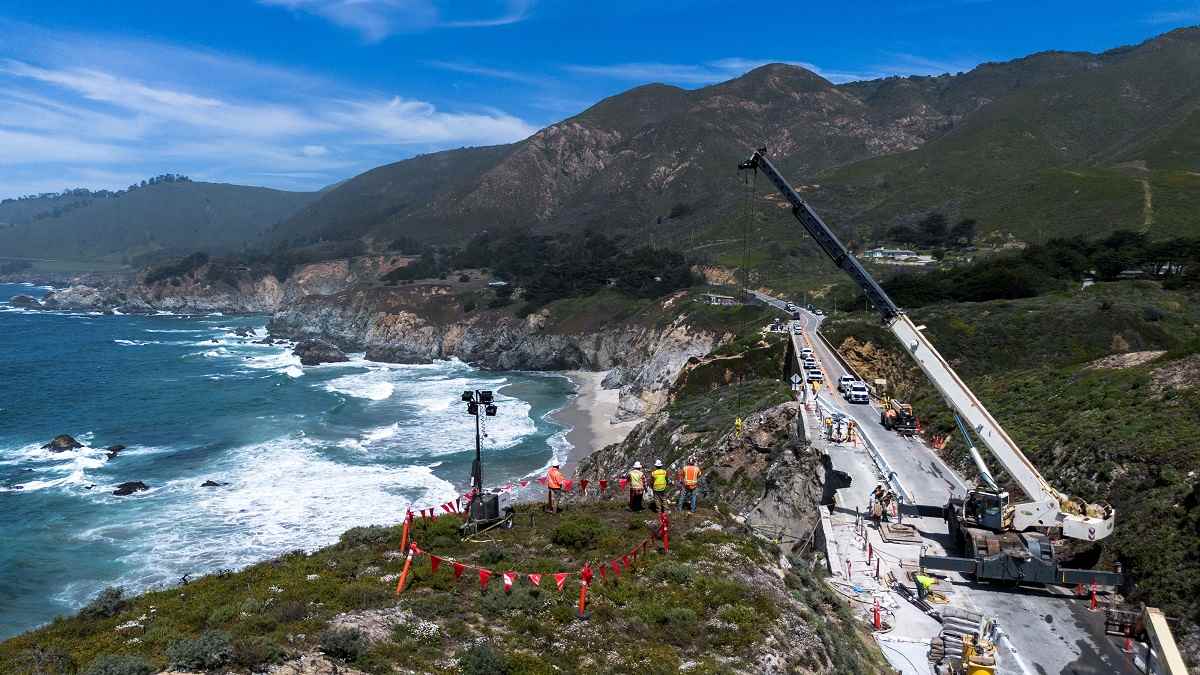
BIG SUR, Calif. – Workers dangle from a crane, drilling into the vertical face of rock that holds up one of the most famous and picturesque stretches of road in the world. They’re performing a delicate surgery on fragile geology in hopes that a single lane of traffic can safely flow to Big Sur before summer arrives.
On this day, it had been nearly a month since a rockslide severed Highway 1, California’s beloved road-trip destination.
Across this stretch of the Central Coast, landslides have repeatedly buried the highway’s undulating curves or sent pavement tumbling into the Pacific Ocean. They bring a steady drumbeat of road blockages, tourism disruptions and stranded communities. Now, some fear the landslides are getting worse, due to climate change and engineering missteps throughout the roadway’s 86-year life span.
It was always a risky proposition to maintain a highway at the very edge of a continent. But now Big Sur is facing wetter storms that infiltrate and weaken cracked and porous rock. Wildfires leave behind extra debris for those floodwaters to carry downhill. Pounding waves from stronger storms and rising seas eat away at cliffs from beneath.
“Everything is working against Highway 1,” said Gary Griggs, an oceanography professor at the University of California at Santa Cruz.
The latest slip-out, known as the Rocky Creek slide, exemplifies the complexity of the problem. It stranded 1,500 people at the end of March as workers were making slow progress addressing three other slides. California’s transportation agency – known as CalTrans – estimates it will take more than $100 million to fix them all – if new slides don’t come first.
California is a national leader in confronting climate change, but making Highway 1 sustainable may be a challenge it cannot surmount. Despite spending a billion dollars a year to fix damage that climate-related stressors inflict on its roadways – plus $100 million in projects to make infrastructure more resilient to climate change – the state is struggling to fortify one of its most prized landmarks.
Some have suggested rerouting Highway 1 inland, but they don’t understand its terrain, or its identity, said state Sen. John Laird (D), a former California natural resources secretary who represents part of the Central Coast in the state legislature. Barriers and boulders armor sections of the road and the cliffs against erosion, but extending those interventions along some 100 miles of highway isn’t feasible, others say.
That leaves few options: Get better at predicting and fixing the landslides, and preventing them when possible. Or else imagine the unthinkable: Giving up on maintaining a continuous 656-mile stretch of blacktop from Orange County to Mendocino County, and letting parts of Highway 1 become dead ends.
CalTrans routinely patrols the cliffsides and deploys remote sensing for signs of movement to predict where the next slide might occur. It is repairing the latest section of crumbled highway with an eye toward the climate of the future, officials said.
“As we rebuild we have to do so with the knowledge that the conditions that have washed out sections of roadway will become more and more common in the future,” CalTrans officials said in a statement. “We have to prepare for that.”
But still, the agency did not expect the most recent slide would hit when and where it did. It’s like a high-stakes game of whack-a-mole – one in which, Laird said, Mother Nature and climate change keep upping the ante.
For now, there is no option but to keep knocking down the obstacles as they come. Nearly everyone interviewed for this article said California wouldn’t be California without this road.
“Of course we have to keep it alive,” Laird said.
The most landslide prone stretch of Highway 1, from around Hearst Castle in San Simeon to Carmel-by-the-Sea and the Monterey Peninsula, has for decades epitomized California’s reputation for scenic and rugged landscapes. It’s where road trippers can get a view of dense redwoods out of one window and crashing waves out of the other, often at the edge of cliffs as much as 500 feet above the beach.
For decades, this region has attracted artists and others seeking beauty and isolation. As the author Henry Miller once wrote, “Big Sur has a climate all its own and a character all its own.”
More recently, the rise of Instagram and selfie culture has helped fuel a crushing surge in tourists to its 33 bridges and postcard-like coastlines to look for whales, sea lions and elephant seals.
“Big Sur’s massive popularity is damaging the very scenic qualities and natural beauty that make the area so precious,” said a 2020 CalTrans study of the highway.
But now, it’s geology that is perhaps more threatening.

CalTrans workers drill into the side of a cliff April 17, installing rock dowels aimed at stabilizing the southbound portion of Highway 1 in Big Sur, Calif.
The ground has been shaky beneath this stretch of Highway 1 ever since it started carrying traffic in 1937, crossing over diverse rock formations that are still in their adolescence, geologically speaking.
Deep down sits the hard crystalline base of the Sierra Nevada some 150 miles to the east. On top of that are layers of sedimentary rock left over from an older mountain range. And then, mixed within, there are shreds of shale like volcanic rocks that were scraped up from the ocean floor as two tectonic plates clashed.
“It’s as if that area went through a blender,” said Jon Warrick, a Santa Cruz-based research geologist for the U.S. Geological Survey.
In older parts of the continent, such as the East Coast, rock formations are older and denser, and therefore not prone to movement. But in Big Sur, gaps and joints still exist from when the rocks first came together along the nearby San Andreas fault, and other secondary faults in the area.
This is the country’s steepest coastline outside of Alaska, according to Kevin Schmidt, another USGS geologist, and when these formations are exposed to the elements, their fragility becomes evident.
Water trickles – and sometimes pours – into the cracks between rocks, reaching layers of clay-rich rock crushed as finely as flour. It turns them into a slick slurry – a recipe for landslides.
Climate change has only juiced up those ingredients. Take what happened in 2017, when one of the region’s wettest winters in a century interrupted an extended drought.
Weeks of heavy January and February rains saturated a mountainside that was already imperceptibly sliding above Highway 1, until, by May, the instability became too much. In an instant, so much earth poured down steep slopes near Mud Creek, the USGS said, that it was enough to “fill a line of dump trucks nearly a thousand miles long.”
It took more than a year and $54 million to reconnect Big Sur communities to points south.
Though it took experts by surprise, Griggs said it shouldn’t have. Two decades earlier, CalTrans had declared the area “very active,” with “high landslide potential” due to weaker bedrock and unstable construction.
The slides often occur weeks, if not months, after rainy weather, with about 90 percent of the region’s rain typically falling between November and April. Geologists add that the stormy pattern of the last two years – the 2022-2023 winter brought record-setting amounts of precipitation – has compounded landslide risks.
Much of that increased rain is likely to come through juiced-up storms known as atmospheric rivers, which can pummel California’s coasts in winter months, sometimes one after another. But even without those, the state is seeing more thunderstorms typical in other parts of the country but less so in California, said Daniel Swain, a climate scientist at UCLA. California, including Big Sur, is seeing precipitation events that are about 10 percent more intense statewide than they have been historically, he said.
Add it all up, and it appears a trend of bigger and more frequent landslides is coming, Warrick added, if it isn’t already here.
The latest Highway 1 interruption feels all too familiar to Big Sur veterans, including Ben Perlmutter, whose family has lived in Big Sur for three generations.
Now 33, Perlmutter has experienced or heard stories about decades of disasters. In 1995, the National Guard had to erect a bridge to reconnect Big Sur to the outside world after a washout. In 1998, Highway 1 collapsed in five places and an Army helicopter had to rescue his family. In 2008, a wildfire ignited nearby, forcing them out of their home for more than a week. In 2017, a landslide closed the highway again, leaving residents cut off for nine months.
Now, “we can’t catch a break,” he said, explaining how the latest slide brought business that was already slow to a grinding halt. Residents can leave and enter Big Sur only in convoys at 7 a.m. and 5 p.m. Tourists, the town’s main source of income, are not yet allowed in – resulting in lost revenue that business owners say amounts to roughly $1 million a day.
Perlmutter, who grew up behind the bar of his father’s restaurant, moved back home with his wife six months ago to take over the Big Sur River Inn from his 91-year-old father and is now unsure if he’s going to break even his first year. He feels responsible for his 77 employees, 60 of whom are now unemployed.
“There is this fatigue level. … You have to totally transform on a dime to prepare your businesses to respond to these disasters,” Perlmutter said, noting that the inn’s financial situation is way worse than before. “A lot of emotion goes into that.”
Even so, Perlmutter and other businesses owners have thrown themselves into community efforts since the latest slide.
Within 24 hours, Perlmutter said his bar manager, a volunteer firefighter and EMT, quickly coordinated places for 1,500 stranded tourists to sleep. The Big Sur River Inn has also hosted a Taco Tuesday, practically giving away food and drinks so they didn’t go to waste. Deetjen’s, another historic inn, has also been serving discounted community breakfasts. Musicians have been playing impromptu shows, for a distraction.
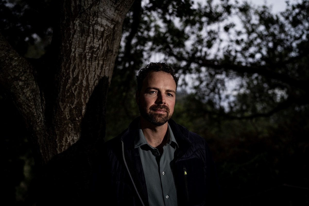
Ben Perlmutter recently moved back to Big Sur to take over the Big Sur River Inn from his father.
Yet these charitable responses can endure for only so long. Costs of doing business keep rising in Big Sur, and bigger corporations continue to move in and subsume long-standing family operations.
“You feel like you are in a rodeo getting bucked continuously,” said Kirk Gafill, who also grew up in a landmark restaurant that he now runs, called Nepenthe. “You are constantly calling on reserves, never knowing what is going to happen.”
Preserving the Big Sur that residents and tourists love sometimes seems like a fantasy venture.
To prepare for bigger storms and help water run off the cliffs, CalTrans officials told The Washington Post they are replacing and enlarging stormwater culverts. They are engineering ways to strengthen the roadway and the cliffs it sits upon.
But sometimes such engineering isn’t possible because of concerns for wildlife, such as an endangered snail known as the black abalone. And it cannot last forever. Longtime residents and officials say that along the rocky coast, walls built during the 1980s to stabilize the road have since eroded and withered away.
CalTrans officials said they have no long-term scheme for maintaining the highway, other than tackling landslides as they emerge and preventing them whenever possible.
But sometimes, there is nothing that could keep cliffs upright. There was a concrete wall at the base of a bridge over Rocky Creek, site of the latest slide, for example. Now, to get a single lane of traffic flowing again, workers are hammering vertical and horizontal supports deep within the cliff and reinforcing it with a sprayed-on material known as shotcrete.
A permanent fix is unrealistic, Griggs said. Even if California turned Highway 1 into a toll road – like the famous 17-Mile Drive on the nearby Monterey Peninsula – all the money in the world could not eliminate landslides, he said. “There are some problems we just don’t have solutions for,” he added.
California received some $375 million to prepare its highways for climate change through the federal bipartisan infrastructure law passed in 2021. While such spending is vital, Laird said, his single Senate district – one of 40 statewide – has transportation needs that could easily consume billions of dollars.
From his perspective, the state should be spending all it can to preserve Highway 1 and access to Bug Sur because it epitomizes what is so unique about California. “It’s a natural mecca,” he said.
Others foresee a day when such investment becomes foolish and preservation becomes impossible. Cheryl Hapke helped lead study of the geology beneath Highway 1, spending 22 years as a USGS research scientist working closely with CalTrans in studying landslide risks. By now, she said, communities continually finding themselves stranded may need to think about relocating.
“I’m not saying do it tomorrow, but at some point, the conversation probably has to be had,” said Hapke, now a Florida-based principal consultant in coastal resiliency for Fugro, an environmental consulting firm.
“We’re living with what we’ve created in this changing climate,” she added. “There’s answers. They’re not easy.”
Top Articles in News Services
-

Survey Shows False Election Info Perceived as True
-
Hong Kong Ex-Publisher Jimmy Lai’s Sentence Raises International Outcry as China Defends It
-

Japan’s Nikkei Stock Average Touches 58,000 as Yen, Jgbs Rally on Election Fallout (UPDATE 1)
-

Japan’s Nikkei Stock Average Falls as US-Iran Tensions Unsettle Investors (UPDATE 1)
-

Trump Names Former Federal Reserve Governor Warsh as the Next Fed Chair, Replacing Powell
JN ACCESS RANKING
-
Producer Behind Pop Group XG Arrested for Cocaine Possession
-

Japan PM Takaichi’s Cabinet Resigns en Masse
-
Man Infected with Measles Reportedly Dined at Restaurant in Tokyo Station
-

Israeli Ambassador to Japan Speaks about Japan’s Role in the Reconstruction of Gaza
-

Videos Plagiarized, Reposted with False Subtitles Claiming ‘Ryukyu Belongs to China’; Anti-China False Information Also Posted in Japan


