To use this site, please disable the ad blocking feature and reload the page.
This website uses cookies to collect information about your visit for purposes such as showing you personalized ads and content, and analyzing our website traffic. By clicking “Accept all,” you will allow the use of these cookies.
Users accessing this site from EEA countries and UK are unable to view this site without your consent. We apologize for any inconvenience caused.
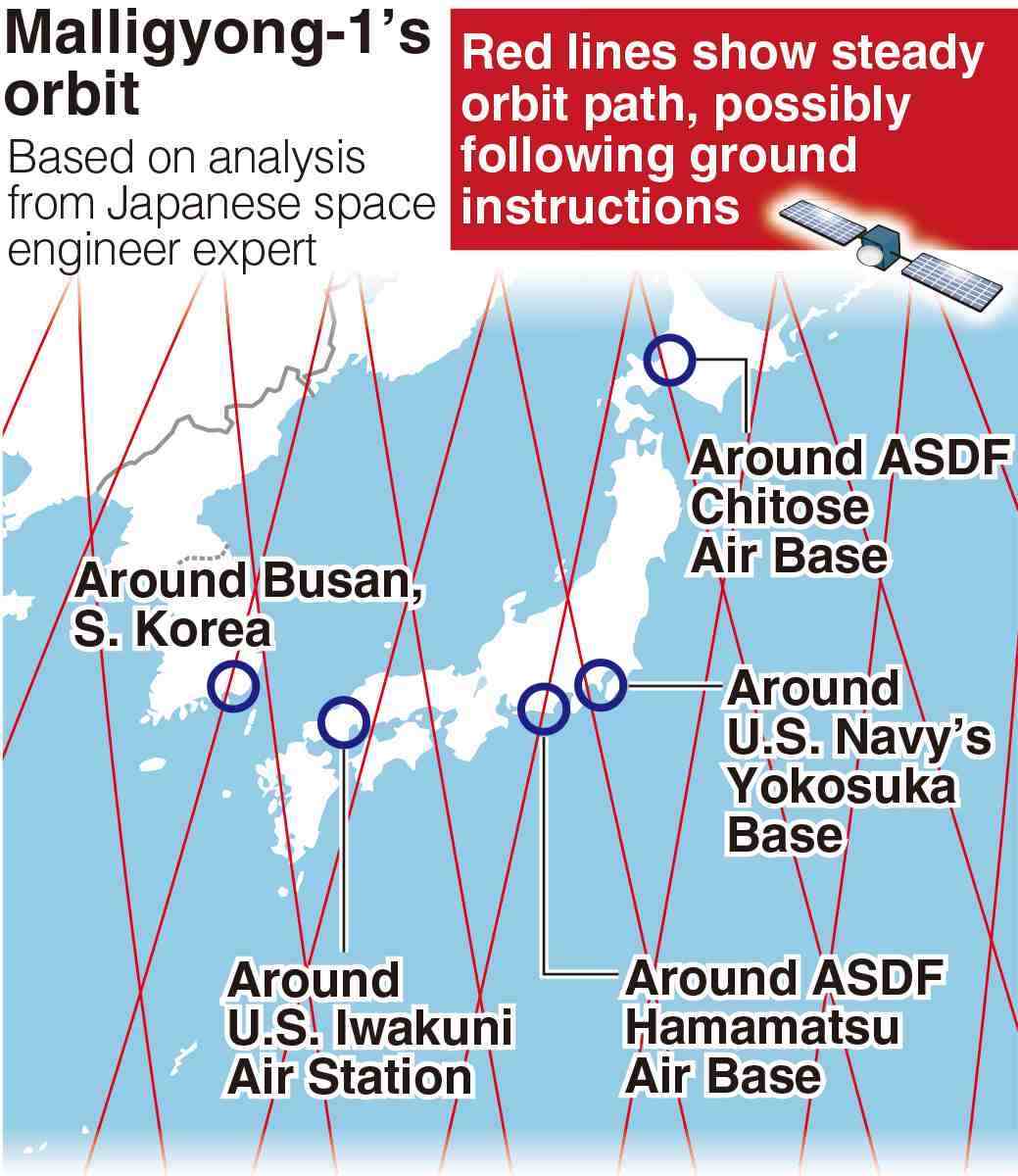
A military reconnaissance satellite launched by North Korea last November was found to have been repeatedly gaining altitude while steadily orbiting the Earth, according to a Japanese expert who analyzed available data from the U.S. military.
The Japanese government is also aware of the satellite’s movement, and are concerned over the possibility that it has been able to follow instructions from the ground.
The satellite, the Malligyong-1, has been registered by the U.S. Space Force on satellite tracking site Space-Track, which publicly releases daily tracking data of satellites and space debris in orbit.
At the request of The Yomiuri Shimbun, the space engineering expert examined data from late November to early March and found that the satellite had gained altitude rapidly at least five times in late February.
Malligyong-1’s average altitude immediately after launch was about 502 kilometers, and it has gradually lowered since then due to what is thought to have been slight air resistance in space. However, the satellite ascended by about 4 kilometers in late February, returning to almost the same orbit as it was immediately after launch.
Defense Minister Minoru Kihara admitted in November that the North Korean satellite was orbiting the Earth and said that careful analysis was needed to determine whether the satellite was following its intended path and fulfilling its functions.
The expert, speaking on condition of anonymity, said: “The altitude has changed rapidly in a short period of time, and it is reasonable to assume that the orbit was artificially adjusted by sending commands from the ground.”
Several Japanese government officials told The Yomiuri Shimbun that they believed the satellite was under Pyongyang’s control.
The analysis shows that the Malligyong-1 passed over the vicinities of the U.S. Iwakuni Air Station in Yamaguchi Prefecture and the South Korean city of Busan, where a military port exists. The analysis also found the satellite could observe the same spot on the ground about once every five days.
North Korea has not released any images, but it claims that the satellite has taken photos of a U.S. atomic-powered aircraft carrier docked in Busan and the U.S. Andersen Air Force Base in Guam.
The satellite’s image capture abilities are still unknown among other capabilities. It is possible that Pyongyang is advancing its technology with help from Moscow, so the Japanese government is working to speed up its analysis by working with Washington and Seoul.