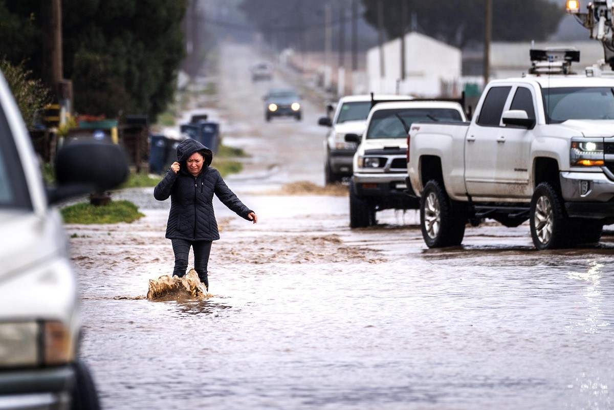
A woman braves flooded streets alongside splashing trucks in Salinas, Calif., during an atmospheric river storm on March 10, 2023.
17:37 JST, March 12, 2023
Heavy rains are washing out roads and leading to emergency rescues in central California as the state braces for more storms in the coming days.
The California National Guard helped with at least 56 rescues in the early hours of Saturday morning after a levee breach inundated the small community of Pajaro in Monterey County. On Saturday, the governor’s office said that it was working to help the largely Latino community, which has a population of just under 3,000.
“My heart hurts tonight for the residents of Pajaro,” Luis Alejo, chair of the Monterey County Board of Supervisors, said in a tweet. “We were hoping to avoid and prevent this situation, but the worst case scenario has arrived with the Pajaro River overtopping and levee breaching at about midnight.”
The local water district warned residents not to drink or cook with tap water until officials had a chance to test its quality after the system’s wells took on floodwater.
As the sun rose over the state, more than 9,000 residents were still under evacuation orders as California continued to be pummeled by what meteorologists call an atmospheric river, extremely moist storms common to the West Coast. It is the 10th such event to hit the state this season.
By early Friday afternoon, the scale of the flooding was already immense. In the San Francisco Bay Area, commuters had to navigate around the flooding, which closed several roads, including a major freeway in Oakland. As of Saturday afternoon, about 32,000 customers in the state remained without power after about 55,000 customers were affected Friday. According to officials, at least two people have died as a result of the latest storms.
The situation only continued to worsen along the state’s Central Coast and Salinas Valley – often called the nation’s “Salad Bowl” because of the leafy greens and other vegetables grown there. In parts of the region, key evacuation routes were impassable as raging floodwaters poured across roads. There was a separate levee break nearly 150 miles away from Pajaro in the community of Cutler in central California’s Tulare County.
Forecasters project that the unrelenting rainfall will last through the coming week.
Although the main slug of moisture associated with the atmospheric river had moved through on Friday, additional moderate to heavy downpours were expected to fan through central and northern California late Saturday and into Sunday. Then, yet another atmospheric river originating from near Hawaii is projected to come ashore.
By Tuesday, 3 to 6 more inches of rain is likely along the coast, with double-digit perception totals in the highest peaks of the Sierra Nevada. That is projected to come down as another 4 to 8 feet of snow in the highest elevations, leading to more flooding, rapid snowmelt and avalanches.
Flood watches remain in effect for locations below 4,000 feet elevation in central and northern California. The National Weather Service office in Hanford, Calif., said many of the creeks and rivers that have been in flood stage since Friday will continue to rise through the weekend.
The Weather Service started issuing flash flood warnings on Friday as heavy rain combined with swift snowmelt to turn creeks and streams into roaring rapids.
The community of Springville in Tulare County, home to about 1,000 residents along Highway 190, was placed under a dire “flash flood emergency” during the morning hours.
“This is a particularly dangerous situation. SEEK HIGHER GROUND NOW!,” warned the Hanford office.
Drone footage revealed dozens of homes treading water, at least one structural collapse and a number of others on the brink of destruction.
In an online warning to residents, the Tulare County Resource Management Agency described the flooding as “unprecedented,” writing, “Roads crews cannot sign every flooded roadway at this time.”
Up to 4.3 inches of rain was reported in Tulare County – which is southeast of Fresno and northeast of Bakersfield – within 24 hours ending Saturday morning. Three to eight feet of water is contained in the Sierra snowpack – likely much more in spots – meaning the warmth of an atmospheric river can quickly melt enough water to effectively double what pours into creeks and streams during a snowstorm.
Meanwhile, mountain communities in the Sierra are working to sort out where to put their ever-accumulating snow. While mostly snow has fallen above 8,000 feet, rain has fallen into the spongy snowpack beneath that.
The Central Sierra Snow Lab off Interstate 80 near Donner Pass, near 7,000 feet, measured a “rain-soaked” 9.3 inches of snow Friday and has tallied 617 inches of snow since October.
That’s converted the snow into a cement-like sludge, which in some instances has caused structural collapses. In other cases, high avalanche danger remains a concern.
Top Articles in News Services
-

Survey Shows False Election Info Perceived as True
-

Hong Kong Ex-Publisher Jimmy Lai’s Sentence Raises International Outcry as China Defends It
-

Japan’s Nikkei Stock Average Touches 58,000 as Yen, Jgbs Rally on Election Fallout (UPDATE 1)
-

Japan’s Nikkei Stock Average Falls as US-Iran Tensions Unsettle Investors (UPDATE 1)
-

Trump Names Former Federal Reserve Governor Warsh as the Next Fed Chair, Replacing Powell
JN ACCESS RANKING
-

Producer Behind Pop Group XG Arrested for Cocaine Possession
-

Japan PM Takaichi’s Cabinet Resigns en Masse
-

Japan Institute to Use Domestic Commercial Optical Lattice Clock to Set Japan Standard Time
-

Man Infected with Measles Reportedly Dined at Restaurant in Tokyo Station
-

Israeli Ambassador to Japan Speaks about Japan’s Role in the Reconstruction of Gaza


