Japan to Offer Southeast Asian Countries Flood Risk Maps; Satellite Data Should Help Improve Public Safety
15:32 JST, May 9, 2024
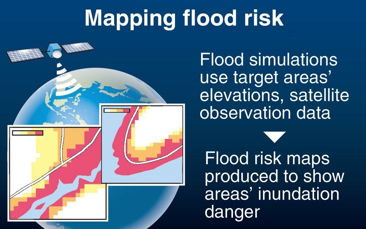
Japan’s land ministry plans to start providing flood risk maps to Indonesia, Thailand, Cambodia and Vietnam next fiscal year to help the Southeast Asian countries reduce damage from flooding. The maps will use satellite observation data to predict flooding caused by heavy rainfall.
The initiative aims to boost Japan’s involvement with the emerging and developing countries collectively known as the Global South and counter China, which is increasing its influence on various countries.
The Land, Infrastructure, Transport and Tourism Ministry already publishes flood risk maps for various parts of Japan, showing the frequency and depth of inundation caused by flooding. Based on observation data collected on the ground, including by rainfall gauges, the maps show the risk of inundation from heavy rainfall likely to occur every 10, 30, 50, 100 and 150 or 200 years, with the information to be used to facilitate smooth evacuation and community planning.
The four Southeast Asian countries are frequently hit by large-scale flooding. This prompted the ministry to think that it would be useful for them to have similar maps that clearly show the risk of flooding in target areas. Because these countries do not have sufficient ground-based observation data, the ministry decided to create maps of specific areas after simulating floods using observation data collected by the Global Satellite Mapping of Precipitation (GSMaP) system, operated by the Japan Aerospace Exploration Agency and others.
The ministry began discussions with the four countries in fiscal 2023 to select the target areas. It plans to provide a prototype version of the map to each country by the end of fiscal 2025.
In addition to preparing guidelines, which include procedures for creating maps, the ministry will also develop human resources through training programs.
The maps are expected to be made available to the public in each country. As many Japanese companies operate in the four countries, it is also expected that the maps will help them draw up business plans in preparation for disasters and select their office or factory locations.
The ministry is also considering providing the maps to other countries.


Most Read
Popular articles in the past 24 hours
-
Japan Seeks to Counter China's Expanding Influence in Pacific by ...
-

Exhibition Featuring Yoshiharu Tsuge’s Manga World Underway in Ch...
-
Tokyo Skytree Observation Deck Remains Closed for Inspection afte...
-

Impact on Japanese Economy Unclear with Trump’s New Tariffs, Shif...
-

Japanese Watermelon Shipments Starts in Leading Production Distri...
-

Hanzomon Line Service Suspended between Kudanshita, Oshiage Stati...
-

Takeshima Day: Persistently Demanding Resolution from South Korea...
-

Japan's Services Inflation Steady, Signals Wage-Driven Price Pres...
Popular articles in the past week
-

Producer Behind Pop Group XG Arrested for Cocaine Possession
-

Japan, U.S. Name 3 Inaugural Investment Projects; Reached Agreeme...
-

iPS Treatments Pass Key Milestone, but Broader Applications Far f...
-

Tokyo Skytree's Elevator Stops, Trapping 20 People; All Rescued (...
-

Director Naomi Kawase's New Film Explores Heart Transplants in Ja...
-

Japan’s Major Real Estate Firms Expanding Overseas Businesses to ...
-

Milano Cortina 2026: Japan’s Mari Fukada Wins Gold in Women’s Sno...
-

Milano Cortina 2026: Japanese Figure Skater Kaori Sakamoto’...
Popular articles in the past month
-
Producer Behind Pop Group XG Arrested for Cocaine Possession
-

Japan PM Takaichi’s Cabinet Resigns en Masse
-

Japan Institute to Use Domestic Commercial Optical Lattice Clock ...
-

Man Infected with Measles Reportedly Dined at Restaurant in Tokyo...
-

Israeli Ambassador to Japan Speaks about Japan’s Role in the Reco...
-

Videos Plagiarized, Reposted with False Subtitles Claiming ‘Ryuky...
-

Man Infected with Measles May Have Come in Contact with Many Peop...
-

Prudential Life Insurance Plans to Fully Compensate for Damages C...
Top Articles in Politics
-
Japan PM Takaichi’s Cabinet Resigns en Masse
-

Sanae Takaichi Elected Prime Minister of Japan; Keeps All Cabinet Appointees from Previous Term
-

Japan’s Govt to Submit Road Map for Growth Strategy in March, PM Takaichi to Announce in Upcoming Policy Speech
-

LDP Wins Historic Landslide Victory
-

LDP Wins Landslide Victory, Secures Single-party Majority; Ruling Coalition with JIP Poised to Secure Over 300 seats (UPDATE 1)
JN ACCESS RANKING
-
Producer Behind Pop Group XG Arrested for Cocaine Possession
-
Japan PM Takaichi’s Cabinet Resigns en Masse
-
Man Infected with Measles Reportedly Dined at Restaurant in Tokyo Station
-
Israeli Ambassador to Japan Speaks about Japan’s Role in the Reconstruction of Gaza
-
Videos Plagiarized, Reposted with False Subtitles Claiming ‘Ryukyu Belongs to China’; Anti-China False Information Also Posted in Japan