Strain on Tectonic Plates Under Japan’s Hyuganada Sea Causes Earthquakes; Has Resulted in More than Five M-7 Quakes Since 1931
10:41 JST, August 10, 2024
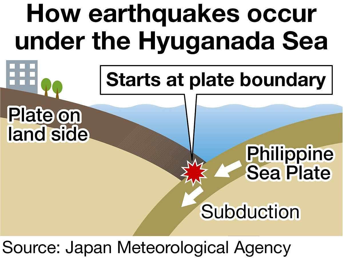
Strain accumulating at the boundary between tectonic plates under the Hyuganada Sea off Miyazaki Prefecture has caused earthquakes of magnitude 7 or greater five times since 1931, before the latest one on Thursday.
The Hyuganada Sea, where Thursday’s earthquake occurred, is on the western edge of the likely epicenter of a possible Nankai Trough earthquake.
The Nankai Trough lies beneath the Pacific Ocean and runs parallel to the Japanese coast from Shizuoka Prefecture, in the Tokai region, to Kyushu.
The Hyuganada Sea is an area where the Philippine Sea Plate (on the ocean side) subducts beneath the plate on the land side, leading to the accumulation of stress underground. This has caused earthquakes of Thursday’s scale to occur numerous times in the past. The Japan Meteorological Agency announced that Thursday’s earthquake had a magnitude of 7.1 and was caused by a shift in the boundary between the two plates.
It was smaller than the massive magnitude 8 quake that has been predicted for the area.
Since 1931, there have been five earthquakes of magnitude 7 or greater in the Hyuganada Sea, the last of which occurred in 1984, according to the agency.
The government’s Headquarters for Earthquake Research Promotion has determined that earthquakes of about magnitude 7 to 7.5 occur on average every 20 years.
In 2022, it estimated the probability of an earthquake of this scale occurring within the next 10 years to be about 40% and within 30 years to be about 80%.
Prof. Masanao Shinohara of the University of Tokyo, who specializes in undersea seismology, said plate boundary earthquakes like Thursday’s “can affect the surrounding boundary surfaces if the boundary surface shifts.”
Related Tags


Most Read
Popular articles in the past 24 hours
-

University of Tsukuba Hospital to Introduce Working Dog Next Year...
-
Record 167 Elementary School Students Harmed Via Social Media in ...
-

Japan’s Hikonyan Cat Mascot to Celebrate 20th Birthday with Party...
-
Nidec Chairman Resigns Amid Accounting Scandal at Major Japanese ...
-
Japan's Kairos Rocket Set to Launch on Sunday After Delays
-

Humbert Humbert: Husband-Wife Vocal Duo Brings Cheerful Singing t...
-
Mizuho to Cut Up to 5,000 Administrative Jobs with AI-Driven Oper...
-
Trump’s Address: Confront the Dead End that Authoritarianism Has ...
Popular articles in the past week
-
Producer Behind Pop Group XG Arrested for Cocaine Possession
-

iPS Treatments Pass Key Milestone, but Broader Applications Far f...
-
Tokyo Skytree's Elevator Stops, Trapping 20 People; All Rescued (...
-

Nepal Bus Crash Kills 19 People, Injures 25 Including One Japanes...
-

Milano Cortina 2026: Japanese Gold Medalist Figure Skater Miura S...
-

Japan’s Major Real Estate Firms Expanding Overseas Businesses to ...
-

Milano Cortina 2026: Japanese Figure Skater Kaori Sakamoto’...
-

Reciprocal Tariffs Ruled Illegal: Judiciary Would Not Tolerate Pr...
Popular articles in the past month
-
Producer Behind Pop Group XG Arrested for Cocaine Possession
-

Japan PM Takaichi’s Cabinet Resigns en Masse
-

Japan Institute to Use Domestic Commercial Optical Lattice Clock ...
-

Man Infected with Measles Reportedly Dined at Restaurant in Tokyo...
-

Israeli Ambassador to Japan Speaks about Japan’s Role in the Reco...
-

Videos Plagiarized, Reposted with False Subtitles Claiming ‘Ryuky...
-

Man Infected with Measles May Have Come in Contact with Many Peop...
-

Prudential Life Insurance Plans to Fully Compensate for Damages C...
Top Articles in Society
-
Producer Behind Pop Group XG Arrested for Cocaine Possession
-
Man Infected with Measles Reportedly Dined at Restaurant in Tokyo Station
-
Man Infected with Measles May Have Come in Contact with Many People in Tokyo, Went to Store, Restaurant Around When Symptoms Emerged
-
Woman with Measles Visited Hospital in Tokyo Multiple Times Before Being Diagnosed with Disease
-
Australian Woman Dies After Mishap on Ski Lift in Nagano Prefecture
JN ACCESS RANKING
-
Producer Behind Pop Group XG Arrested for Cocaine Possession
-
Japan PM Takaichi’s Cabinet Resigns en Masse
-
Man Infected with Measles Reportedly Dined at Restaurant in Tokyo Station
-
Israeli Ambassador to Japan Speaks about Japan’s Role in the Reconstruction of Gaza
-
Videos Plagiarized, Reposted with False Subtitles Claiming ‘Ryukyu Belongs to China’; Anti-China False Information Also Posted in Japan