To use this site, please disable the ad blocking feature and reload the page.
This website uses cookies to collect information about your visit for purposes such as showing you personalized ads and content, and analyzing our website traffic. By clicking “Accept all,” you will allow the use of these cookies.
Users accessing this site from EEA countries and UK are unable to view this site without your consent. We apologize for any inconvenience caused.
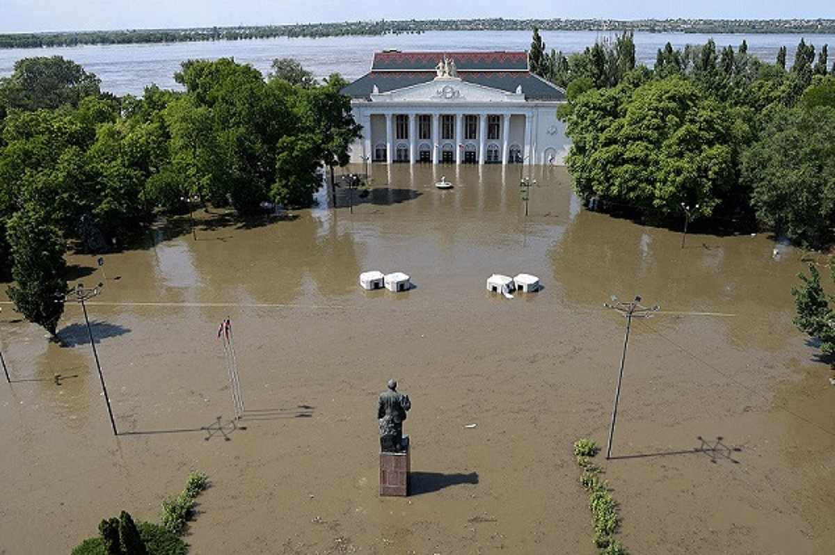
Alexey Konovalov/TASS/Handout via REUTERS The House of Culture on a flooded street in Nova Kakhovka, Kherson Region, Russian-controlled Ukraine, June 6, 2023.
By Mariano Zafra and Dea Bankova
16:20 JST, June 9, 2023
Analysts from the United Nations Satellite Centre – Unosat have begun to assess the damage caused by the collapse of the Nova Kakhovka dam in Ukraine on June 6.
Preliminary analysis of satellite images of the nearby city of Nova Kakhovka has concluded there is significant flooding and damage to buildings along both banks of the Dnipro River below the dam’s reservoir.
The dam’s reservoir holds 18 cubic kilometres (4.3 cubic miles) of water – a volume roughly equal to the Great Salt Lake in the U.S. state of Utah.
It is not known how many people may have died as a result of the flooding. The Russian-installed mayor of Nova Kakhovka said on Thursday at least five people had died but the total death toll is sure to be much higher.
Downstream, UN analysis shows significant flooding along a 90 km stretch of the Dnipro River to the Black Sea.
Hundreds of Ukrainians were rescued from rooftops in the flood-stricken southern region of Kherson on Thursday after floodwaters submerged villages, fields and roads.
Kherson’s Ukrainian governor, Oleksandr Prokudin, said 68% of the flooded territory was on the Russian-occupied bank of the Dnipro River.
The “average level of flooding” in the Kherson region on Thursday morning was 5.61 meters (18.41 ft), he said.
Russia and Ukraine have traded blame for the bursting of the Soviet-era dam and also accused each other on Thursday of shelling the area as rescue workers in rubber dinghies tried to save people and animals from the still-rising flood waters.
A Reuters reporter in Kherson, about 60 km (37 miles) downstream from the dam, said he could hear what sounded like artillery fire but could not immediately provide details.