To use this site, please disable the ad blocking feature and reload the page.
This website uses cookies to collect information about your visit for purposes such as showing you personalized ads and content, and analyzing our website traffic. By clicking “Accept all,” you will allow the use of these cookies.
Users accessing this site from EEA countries and UK are unable to view this site without your consent. We apologize for any inconvenience caused.
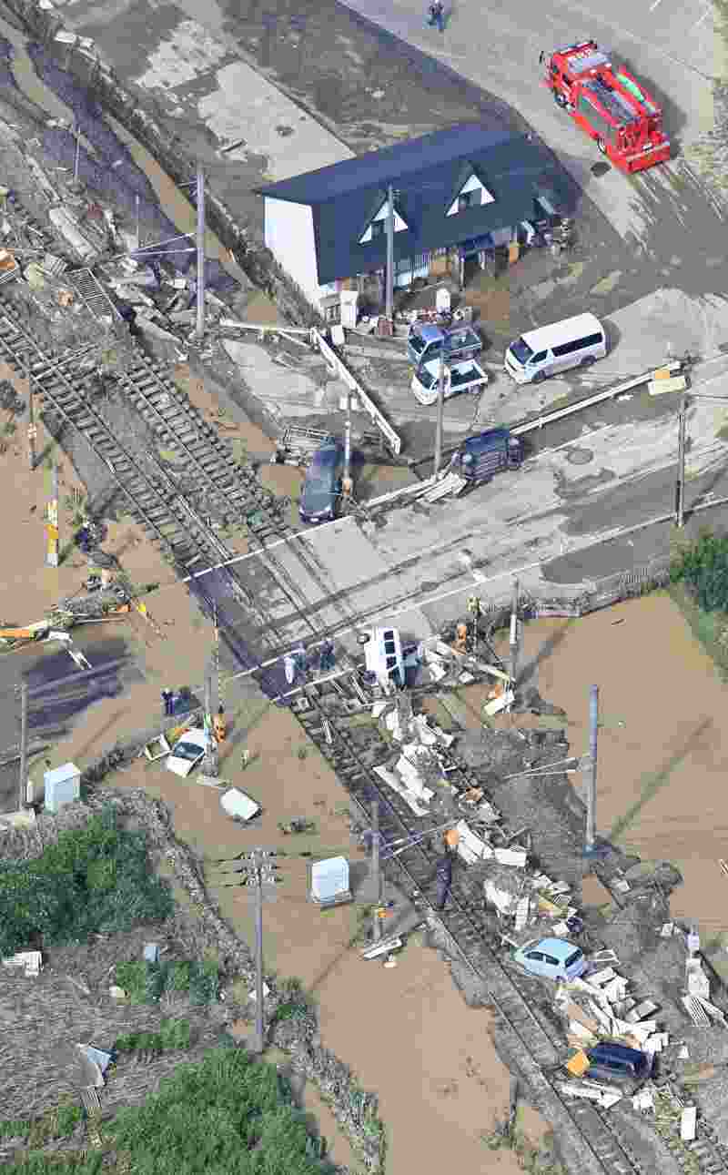
The Yomiuri Shimbun Vehicles and debris are seen scattered on and around railroad tracks after a levee broke following a downpour in Minami-Echizen, Fukui Prefecture, on Aug. 5.
The Yomiuri Shimbun
6:00 JST, August 22, 2022
The Japan Meteorological Agency has issued 115 special heavy-rain warnings from July until mid-August, three times more than for the same period last year.
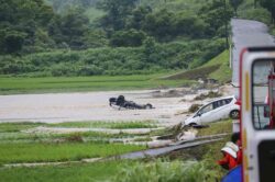
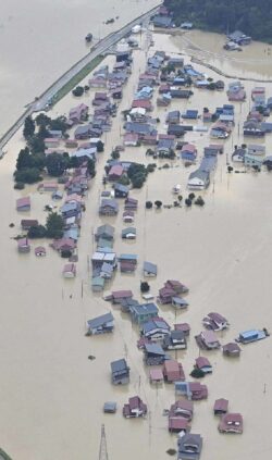
Localized downpours have hit many areas this summer, causing multiple landslides and other damage. Sea surface temperatures — one of the possible factors behind the heavy rains — are expected to remain high through September and the JMA has called on the public to remain vigilant.
“Rain was pummeling the ground so hard, I thought it was dangerous,” said a Fukui Prefecture, Minami-Echizen municipal government official, recalling how the town experienced a record-high 405.5 millimeters of rain over 24 hours from the morning of Aug. 4. The rain caused a levee to collapse and about 200 houses were destroyed, damaged or flooded, while some sections of a national highway and the Hokuriku Expressway running through the town were closed due to landslides.
According to the Cabinet Office, heavy rains across the nation from Aug. 3-17 caused damage to more than 5,400 houses in 18 prefectures, including Niigata, Ishikawa and Yamagata, as well as Fukui.
“There’s no doubt that unusually heavy rain has been falling in many parts of the nation,” a JMA official said.
The agency issues special warnings called “information on short-period record-breaking downpours” when an intense deluge is expected at a level that is likely to be observed only once every several years. From July through Aug. 17, such warnings were issued 115 times, significantly more than the 33 alerts issued from July to August last year.
Tetsuya Takemi, a professor of meteorology at Kyoto University’s Disaster Prevention Research Institute, said two factors underpin this summer’s deluges: a rise in sea surface temperatures and the southward movement of a weather front.
Currently, La Nina is cooling sea surface temperatures in parts of the Pacific off the coast of Peru, causing extreme weather worldwide. La Nina is also responsible for making the trade winds — which blow from east to west — even stronger than usual, pushing warm seawater into the western side of the Pacific and raising sea surface temperatures around Southeast Asia and Japan.
Rising sea surface temperatures can cause large amounts of water vapor to form. This vapor coheres into cumulonimbus clouds, according to the professor. Such conditions increase the likelihood of linear rainbands — chains of cumulonimbus clouds that offload copious rains in one location.
Furthermore, westerly winds have been meandering south since July, pushing a front closer to the Japanese archipelago. A large amount of water vapor is believed to have moved toward the front, causing the recent heavy downpours.
Since July, sea surface temperatures have exceeded 27 C on the Pacific coast up to the Kanto region, with the figure hovering at around 30 C this month. These figures are both 1 to 2 degrees higher than usual. Takemi said rises of this size can increase the formation of water vapor by nearly 10%.
In its latest forecast for the coming month, the JMA said sea surface temperatures around Japan will likely be higher than normal, meaning the high risk of heavy rain is set to continue.
“La Nina and the southward shift of the front brought torrential rains to Kyushu in 2020, causing record-breaking rainfalls over a wide area,” Takemi said. “Heavy deluges could occur anywhere this summer and I’d advise people to check weather information frequently.”