To use this site, please disable the ad blocking feature and reload the page.
This website uses cookies to collect information about your visit for purposes such as showing you personalized ads and content, and analyzing our website traffic. By clicking “Accept all,” you will allow the use of these cookies.
Users accessing this site from EEA countries and UK are unable to view this site without your consent. We apologize for any inconvenience caused.
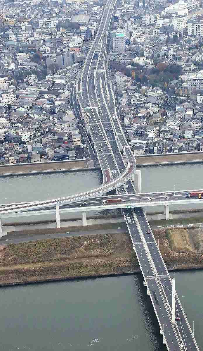
The Yomiuri Shimbun The Metropolitan Expressway is seen with the Arakawa river in the foreground in Edogawa Ward, Tokyo, on Saturday.
The Yomiuri Shimbun
18:01 JST, December 14, 2020
The Tokyo metropolitan government is planning to use elevated sections of the Metropolitan Expressway in five eastern wards as emergency evacuation sites in the event of large-scale flooding, The Yomiuri Shimbun has learned.
The five wards are Sumida, Koto, Adachi, Katsushika and Edogawa. Officials are concerned that most parts of these wards could be flooded in the event of heavy rain, forcing up to 2.5 million people to evacuate.
The metropolitan government, the Land, Infrastructure, Transport and Tourism Ministry, and each ward office will begin full-fledged discussions on how to operate envisaged evacuation sites, according to sources.
The idea of using elevated expressway sections as evacuation sites in times of disaster has been widespread since the 2011 Great East Japan Earthquake, when massive tsunami struck a large swathe of the country’s northeastern coast.
According to the ministry, such sites have so far been created at about 400 locations on the Tomei Expressway in Shizuoka Prefecture, the Hanshin Expressway’s Wangan Route in Osaka Prefecture and the Higashi-Kyushu Expressway in Miyazaki Prefecture, among other places.
In September, the ministry compiled survey results that found a total of 1,780 kilometers of expressway sections and national highways nationwide were available as evacuation sites, encouraging local governments to use them.
The five eastern Tokyo wards are surrounded by the Arakawa and Edo rivers with vast areas as low as sea level. If the two rivers were to flood at the same time, areas where up to 2.5 million people live could be inundated. Flooding in some places could reach 10 meters deep and take more than two weeks to recede.
Based on the projections, the five ward offices in 2018 compiled a “wide-area evacuation” plan to evacuate residents from the wards to neighboring municipalities.
In October last year when Typhoon No. 19 was approaching Tokyo, the ward offices considered executing the plan, but had to shelve it because railway companies announced in advance that they would suspend services, making it difficult for people to evacuate to neighboring municipalities.
After that, the five ward offices shifted focus to studying viable evacuation methods within the wards, such as “vertical evacuation” in which people move up to the upper floors of buildings.
To that end, some ward offices have secured cooperation from public housing facilities and hotels, but accommodating all residents would be difficult. The task is to find more evacuation sites.
The metropolitan government and others are considering opening the elevated sections of the Metropolitan Expressway running through the five wards for residents to evacuate to the sections with stairs and ramps from the ground when the risk of flooding heightens due to expected heavy rains caused by approaching typhoons and other factors.
There is also a plan to set up evacuation facilities on the elevated expressway.
“Large numbers of people can be accommodated, and vehicles can also be dispatched for rescue,” a senior metropolitan government official said.
However, on the other hand, the Metropolitan Expressway is also used as a passage for emergency vehicles. The metropolitan government plans to discuss with relevant organizations the selection of sections available for traffic lane restrictions as well as the procedure for closing them in consultation with the five ward offices.
“If ‘vertical evacuation’ to the Metropolitan Expressway becomes possible, it will be one of the effective options to protect residents’ lives,” said Masayuki Yamaguchi, chief of the crisis management office of the Edogawa ward office.