
Windows are taped in anticipation of typhoon Saola at a boutique in Hong Kong, China August 31, 2023.
14:55 JST, September 1, 2023
Typhoon Saola – the equivalent of a Category 4 hurricane – is closing in on Hong Kong and coastal southeast China. As it does so, transportation, government, businesses and schools have come to a halt across the region.
The storm is expected to scrape ashore as a weakening but powerful typhoon late Friday and into Saturday local time, following a peak intensity of 150 mph (130 knots) Thursday, when it was briefly considered a super typhoon.
Still packing 140 mph (120 knots) winds, Saola was about 150 miles offshore Hong Kong early Friday morning local time and moving east around 6 mph (5 knots), according to the Joint Typhoon Warning Center (JTWC).
In anticipation of Saola, the Hong Kong Observatory issued a Storm Signal No. 8, the third highest level on a scale that goes up to 10. Higher warning signals are possible as the typhoon approaches Friday.
“Local weather is expected to deteriorate significantly later today, with heavy squally showers and violent winds,” the observatory wrote in a pre-dawn update.
Typhoons in the northwest Pacific are no different from hurricanes in the tropical Atlantic. Typhoons whose maximum winds reach at least 150 mph are called super typhoons.
Schools, businesses and the Hong Kong stock market closed Friday in advance of the storm, according to Reuters. The city’s mayor John Lee posted to Facebook that he has requested all city units to be fully deployed to manage the storm threat.
China has suspended 121 passenger trains in the region through Sept. 6, according to reports from the Associated Press. The AP also noted that fishing boats have been called to port, while cities near the potential landfall point in Guangdong Province have stopped most activities until an all-clear after the storm.
Although Saola is forecast to weaken on approach to land, sustained winds around 100 mph (85 knots) are forecast as it makes its closest approach to Hong Kong. At that time, wind gusts up to 120 mph (105 knots) also remain possible right near the water.
While very intense, Saola is a fairly compact system. The most recent advisory showed hurricane-force winds are confined to within 25 miles of the center and tropical storm winds largely within 100 miles.
In addition to the strong winds, flooding rainfall of 6 to 12 inches is a risk in the hardest hit spots around Hong Kong and Macao, then inland around Shenzen and Jiangmen in Guangdong Province. The hefty amounts and rapid accumulation of rain may lead to urban and river flooding, as well as landslides.
A life-threatening storm surge – or rise in ocean water above normally dry land – will occur in low-lying coastal areas, regardless of any weakening. Wave heights were up to 46 feet around the center of the storm early Friday, according to JTWC reports.
If it does make landfall, the storm may be among the most intense to do so in the region in modern history. Even a scrape from such a storm is significant.
The broader region sees a tropical storm or typhoon threaten about once every two years on average. Hong Kong itself is a rather small target. Its last direct landfall came from Nuri in 2008, which hit as a tropical storm after peaking as a Category 3 typhoon earlier in its life.
Typhoon Hato in August 2017 caused the closure of much of Hong Kong as it passed to the southwest and led to numerous injuries and widespread damage across the region. Dujuan in September 2003 took a path across the northern portion of Hong Kong as a Category 2 typhoon but the worst conditions affected areas to the north in mainland China.
Related Tags


Most Read
Most read in the last 24 hours
-

Trump Extends the Ceasefire with Iran but Keeps the Blockade
-

China, South Korea Object to Japanese PM Takaichi's Ritual Offeri...
-

Florida Launches Criminal Probe into OpenAI and ChatGPT over Dead...
-

Trump Opposes United–American Merger, Signals Support for Spirit
-

Trump Picks a University of Minnesota Professor to Lead His Econo...
-

Japan's ANA to Introduce Fuel Surcharges to Domestic Flights from...
-

Taiwan President Cancels Africa Trip Blaming Chinese Pressure
-

Fired Former UK Official Says He Felt Political Pressure to Appro...
Most read in the last 7 days
-
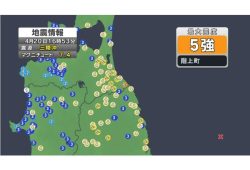
Earthquake Hits Japan's Tohoku Region; 3-meter Tsunami Warning Is...
-
Trump Extends the Ceasefire with Iran but Keeps the Blockade
-

Olympic Gold Medal-Winning Figure Skaters Riku-Ryu Announce Retir...
-
China, South Korea Object to Japanese PM Takaichi's Ritual Offeri...
-

Japan to Ban Use of Portable Chargers on Airplanes from April 24,...
-

New Challenges Await as Miura-Kihara Retires; Blade Maker, Ex-Coa...
-
Florida Launches Criminal Probe into OpenAI and ChatGPT over Dead...
-
Trump Opposes United–American Merger, Signals Support for Spirit
Most read in the last 30 days
-
Earthquake Hits Japan's Tohoku Region; 3-meter Tsunami Warning Is...
-

Police Find Child's Shoe During Search for Missing Boy in Nantan,...
-
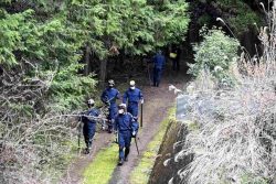
Body Found in Nantan, Kyoto Prefecture, During Search for 11-Year...
-

Cherry Blossoms, Rapeseed Flowers Perform Colorful ‘Duet’ in Niig...
-
Trump Extends the Ceasefire with Iran but Keeps the Blockade
-
Olympic Gold Medal-Winning Figure Skaters Riku-Ryu Announce Retir...
-

Nori Prices Surge in Japan Due to Poor Seaweed Production Amid Ri...
-

Japanese Prime Minister Takaichi Speaks to Pakistani Prime Minist...
Top Articles in News Services
-
Trump Extends the Ceasefire with Iran but Keeps the Blockade
-
Florida Launches Criminal Probe into OpenAI and ChatGPT over Deadly Shooting
-
Trump Opposes United–American Merger, Signals Support for Spirit
-
Trump Picks a University of Minnesota Professor to Lead His Economic Council
-
Taiwan President Cancels Africa Trip Blaming Chinese Pressure
JN ACCESS RANKING
-
Earthquake Hits Japan’s Tohoku Region; 3-meter Tsunami Warning Issued (Update 1)
-
Police Find Child’s Shoe During Search for Missing Boy in Nantan, Kyoto Prefecture
-
Body Found in Nantan, Kyoto Prefecture, During Search for 11-Year-Old Boy in Area (Update 1)
-
Cherry Blossoms, Rapeseed Flowers Perform Colorful ‘Duet’ in Niigata
-
Trump Extends the Ceasefire with Iran but Keeps the Blockade
Most read in the last 24 hours
-
Trump Extends the Ceasefire with Iran but Keeps the Blockade
-
China, South Korea Object to Japanese PM Takaichi's Ritual Offeri...
-
Florida Launches Criminal Probe into OpenAI and ChatGPT over Dead...
-
Trump Opposes United–American Merger, Signals Support for Spirit
-
Trump Picks a University of Minnesota Professor to Lead His Econo...
Most read in the last 7 days
-
Earthquake Hits Japan's Tohoku Region; 3-meter Tsunami Warning Is...
-
Trump Extends the Ceasefire with Iran but Keeps the Blockade
-
Olympic Gold Medal-Winning Figure Skaters Riku-Ryu Announce Retir...
-
China, South Korea Object to Japanese PM Takaichi's Ritual Offeri...
-
Japan to Ban Use of Portable Chargers on Airplanes from April 24,...
Most read in the last 30 days
-
Earthquake Hits Japan's Tohoku Region; 3-meter Tsunami Warning Is...
-
Police Find Child's Shoe During Search for Missing Boy in Nantan,...
-
Body Found in Nantan, Kyoto Prefecture, During Search for 11-Year...
-
Cherry Blossoms, Rapeseed Flowers Perform Colorful ‘Duet’ in Niig...
-
Trump Extends the Ceasefire with Iran but Keeps the Blockade