To use this site, please disable the ad blocking feature and reload the page.
This website uses cookies to collect information about your visit for purposes such as showing you personalized ads and content, and analyzing our website traffic. By clicking “Accept all,” you will allow the use of these cookies.
Users accessing this site from EEA countries and UK are unable to view this site without your consent. We apologize for any inconvenience caused.
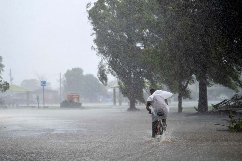
REUTERS/Ricardo Arduengo A man rides his bicycle on a flooded street in the aftermath of Hurricane Fiona in Salinas, Puerto Rico September 19, 2022.
The Washington Post / Matthew Cappucci
15:26 JST, September 20, 2022
Within two days, a pair of disasters struck opposite corners of North America: The entire island of Puerto Rico lost power on Sunday as Hurricane Fiona brought damaging winds and devastating flooding to the U.S. territory – a meteorological catastrophe mirrored by another severe storm that battered parts of Alaska.
In Puerto Rico, up to 2 feet of water washed away bridges, carved chasms in the ground and is in the midst of triggering hundreds to thousands of mudslides. President Biden has already issued a disaster proclamation for the island.
Alaska, particularly the Seward Peninsula, suffered a destructive hit by the remnants of Pacific Typhoon Merbok on Friday and Saturday, which brought hurricane-force winds and a 10-foot storm surge.
Both storms affected marginalized communities in often-overlooked regions of the United States – in Puerto Rico, where the entire island is frequently treated as a distant cousin of the U.S. mainland, and in Alaska, where Indigenous populations reliant on fishing and hunting for subsistence were among the hardest hit.
The comparably remote nature of both impact zones – Puerto Rico being an island whose road network was made largely impassible by flooding, and isolated villages in coastal Alaska that have no roads outside of town – will make recovery efforts even more challenging. Dispatching supplies and personnel will require exceptional mobilization efforts.
There are indications that both storms, particularly the one that struck Alaska, bear the fingerprint of human-induced climate change. Warmer ocean waters are allowing stronger storms to creep to higher latitudes, while warmer air temperatures carry more moisture and fuel more extreme rainfall.
Fiona was declared a Category 1 hurricane at 11 a.m. Sunday. It made landfall along the southwestern coast of Puerto Rico near Punta Tocon at 3:20 p.m. Winds in Ponce, Puerto Rico’s second largest city, gusted to 103 mph.
Power outages accumulated throughout the morning hours before an islandwide blackout hit before landfall.
In early September of 2017, Hurricane Irma scraped the island with tropical storm conditions, knocking out power to 1 million customers. Less than three weeks later, Hurricane Maria’s Category 4 assault on the territory crippled the island and wiped out power everywhere. Even two months later, half of the island’s population remained in the dark.
The powerful impact on Sunday was reminiscent of those blackouts five years ago. As of Monday morning, roughly 10 percent of the island, primarily in the greater San Juan area, had power restored.
Arguably even more problematic were Fiona’s heavy rains, which rivaled or, in some cases, exceeded the deluge brought by Maria. Nearly the entire island was under simultaneous flash flood warnings, and a number of bridges – including some temporary bridges erected after Maria in 2017 – washed away.
Ponce reported 24.67 inches on Sunday night, though that number is likely to have climbed since. Coamo was at 20.64 inches, and nearby Vacas, also in south central Puerto Rico, sat at 20.85 inches. The greatest total received so far came in southeastern Puerto Rico in the town of Espino, where 24.76 inches fell.
From a wind standpoint, Fiona wasn’t terribly strong. Maximum sustained winds at the time of landfall were around 85 mph, but that was in the eyewall over a very small area.
As a point of comparison, Maria came ashore in 2017 as a high-end Category 4 with 155 mph winds; the root cause of the disaster this time was two fold – a beleaguered electrical infrastructure susceptible to even modest winds and the heavy rainfall that wrought havoc on road networks.
Many were quick to blame climate change for the disaster. Among them was Sen. Edward J. Markey (D-Mass.), who tweeted that the “climate crisis is here and I’m ready to . . . combat the climate crisis to end this pattern of extreme weather.”
Since 1851, there have been 136 named storms and hurricanes that have passed within 60 miles of Puerto Rico. Hurricanes are far from unusual in the Greater Antilles or Caribbean.
It is possible that water temperatures, which are a degree or two warmer than average, may have contributed to higher rainfall rates and thus totals. There is also research to suggest storms are decaying over land more slowly and may sometimes move at a more gradual pace – that means the longer they linger over an area, the more rainfall comes down there.
The devastating blow in Alaska also has ties to the tropics: Though Alaska is too far north to experience a truly tropical storm, the state still saw hurricane-force impacts from the remnants of a tropical system.
Typhoon Merbok passed about 2,000 miles east of Japan toward the middle of last week. It was a Category 1-equivalent over the open north Pacific. Eventually, it outran warm ocean waters while recurving to the north, but was energized by a mid-latitude shortwave, or pocket of low pressure, cold air and spin at high altitudes, that hastened its transition into an “extratropical,” or nontropical, storm.
That infused it with jet stream support and carved it into a comma-shaped monster with an air pressure akin to that of Superstorm Sandy in 2012.
It delivered 70 to 90 mph wind gusts to Alaska’s Aleutian Peninsula on Friday and a storm surge typical of a Category 3 hurricane. In Nome, on the Seward Peninsula, water levels reached 10.5 feet above the low tide line, the highest water level since 1974.
The storm carried debris into downtown Nome, where inundated streets became indistinguishable from the nearby ocean. Vehicles and boats appeared parked next to one another.
In Golovin, virtually every structure was treading water during the height of the storm; in some cases, sea levels reached the windows of buildings.
Multiple elements underscore how this storm was likely made worse by the effects of human-induced climate change. Ocean temperatures have ranged between three and seven degrees above average in the north Pacific, and the Arctic is already one of the fastest-warming places in the world. That allowed Merbok’s post-tropical self to charge on unimpeded and even intensify in terms of wind speed.
A dwindled amount of sea ice also meant less of a protective “buffer” to dampen the battering of waves at the coastline, which were responsible for most of the damage.
Alaska climatologist Rick Thoman wrote in an article about the role Indigenous fishing and hunting camps – many of which were destroyed by the storm – play in the region’s economy, and noted the devastating impact of the event.
“Because of the region’s subsistence economy, those camps are crucial, and they are expensive to rebuild,” he wrote.