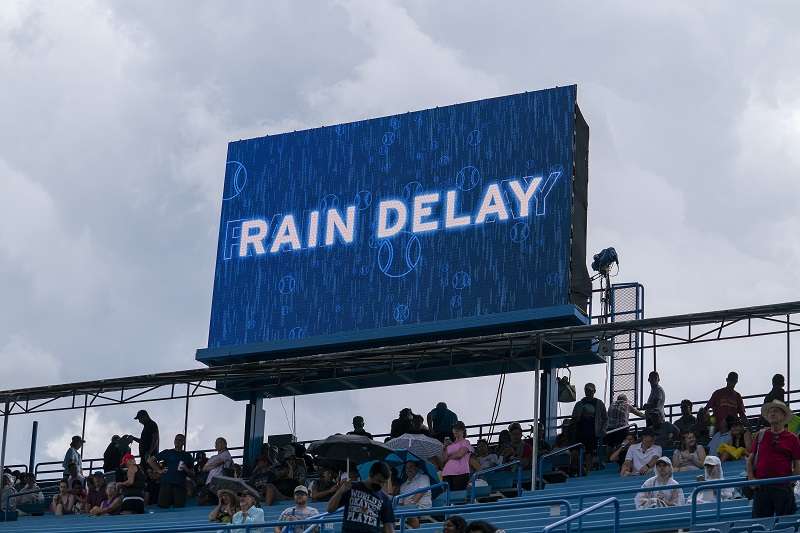
Aug 20, 2022; Cincinnati, OH, USA; Rain suspends play during the Caroline Garcia (FRA) and Aryna Sabalenka (BLR) match at the Western & Southern Open at the Lindner Family Tennis Center.
14:20 JST, August 24, 2022
Five weeks. Five instances of 1,000-year rain events. If it seems like the weather across the Lower 48 as of late has been bonkers, you’re not imagining things. It’s been a maelstrom of weather extremes, a seesaw fluctuating wildly from significantly dry to record wet conditions.
Parts of the United States, especially in the West, are gripped by an inveterate and devastating drought, yet many drought-stricken areas have experienced rare and extreme flooding over the summer – bringing fiercely different precipitation extremes to the region in a matter of hours.
On Monday, parts of the Dallas-Fort Worth Metroplex awoke to torrential downpours that dropped totals of 10 to 16 inches, bringing calamitous impacts and prompting widespread water rescues. Entire neighborhoods near the suburb of Mesquite were left beneath water, and at least one person died.
What happened in the Dallas area came after the city and 29% of the state were gripped in a top-tier “exceptional” drought which impacted crops and drove water shortages. Some farmers were forced to thin their herds in a process called “culling” according to the U.S. Drought Monitor. DFW International Airport was 11.11 inches behind for rainfall since January 1.
Then Monday became the airport’s wettest calendar day on record.
The extreme rainfall in Dallas was a “1,000-year rain event,” an episode of flooding that has just a 0.1% probability of happening in any given year. It joins the company of 1,000-year rain events that struck Kentucky, St. Louis, eastern Illinois and Death Valley, Calif., since the end of July – all of which were experiencing abnormally dry conditions or in a severe drought beforehand.
Droughts can often make flooding worse. Droughts kill plants and leaves the ground bare, reducing soil absorption. They also harden top soils, which makes it easier for water to run off. The extremely dry ground, combined with the rapid rainfall, can trigger widespread flooding.
While no single weather event is caused by mankind’s influence on the atmosphere, the weather facing the nation bears the fingerprint of a warming world. While it seems contradictory, both drought and flooding are closely tied to human-driven warming, and are altering our environment and how we interact with it.
We are witnessing firsthand the effects of ordinary weather events – a product of chaotic randomness and natural variability – supercharged by climate change.
What is a 1,000-year rain event?
We haven’t been taking measurements for 1,000 years, so how can we know what constitutes a 1,000-year rain event? It comes from constructing what’s called a probability distribution, and requires some basic grade-school statistics.
Using an available data set of, say, 100 years or so, we can plot the frequency of rain events of varying magnitudes for a given time window. Once that’s done, we can note the shape of whatever distribution results. Think back to the bell curve in math class – most of the data is clumped around the middle, with more extreme events on the edges as frequency trails off. Finding the likelihood of an extreme weather event is similar.
From there, meteorologists and statisticians extract “recurrence intervals,” or the average frequency with which a given extreme event should occur. That means a 1,000-year rain event has an 0.1% chance of happening in any given year. A 100-year event would have a 1% chance, and so on.
Nowadays, however, our climate is evolving rapidly enough that previously-defined recurrence intervals based on historic data may no longer apply. Michael Mann, a climate scientist at Penn State University, explained that today’s climate is making some of these reference points relics of the past.
“Recurrence intervals start to lose their meaning for ‘nonstationary’ systems,” he wrote, “in this case because there is a trend toward greater extremes in a warming climate.”
In a 2017 paper, he found the return period of a 7.4-foot storm surge flood in New York City had decreased from once every 500 years in preindustrial times to once every 25 years since. It could become a once-per-five-year event toward the middle of the century. Precipitation extremes follow a similar trend.
Five 1,000-year rain events in five weeks
It’s normal that somewhere will see a 1,000-year rain each year. It’d be abnormal if that wasn’t the case. But five in five weeks is extreme, and hints at an overarching trend.
– On the morning of July 26, St. Louis awoke to historic flooding in the city. A staggering 7.87 inches of rain fell in six hours during the morning commute, inundating vehicles and prompting hundreds of water rescues. It came from training thunderstorms, or storms moving along a stalled frontal boundary. A total of 8.64 inches was logged for the day, becoming St. Louis’s wettest day on record. It crushed the previous record of 5.59 inches on May 16, 1995, by a wide margin; records date back to 1931. Some places west of the city received close to 13 inches.
– On July 27, rains began in eastern Kentucky north of Hazard and quickly turned fatal. Rainfall rates topping 2 inches per hour contributed to rapid rises on area rivers, including the North Fork of the Kentucky River at Whitesburg, which rose 11 feet in five hours. That was 6 feet above the previous record. The water probably kept rising, but the sensor was washed away. It was another 1,000-year rain event that tragically killed 38 people.
– On the night of Aug. 1, training thunderstorms in eastern Illinois dumped 8 to 13 inches of rain in about 12 hours near the town of Effingham. Fortunately the landscape was able to handle the rainfall, but there were some reports of flash flooding.
– On Aug. 5, heavy storms dumped 1.46 inches of rain on Death Valley, Calif. That doesn’t sound like much, but it’s just 0.01 inches shy of the all-time daily record. Given the rapidity with which it fell, it was classified as a 1,000-year rain event. Death Valley averages just 0.11 inches of rain in August; 1.46 inches is equivalent to nine months’ worth of rainfall. According to the Park Service, the flooding destroyed a water system that serves numerous park residences and facilities. A number of vehicles were also damaged.
– On Aug. 22, moisture pooling on a stalled frontal boundary over Dallas translated to training thunderstorms. DFW International Airport saw both its wettest day and wettest hour on record. Flash flood warnings were issued across the city.
All five events stemmed from stationary fronts and anomalously-humid air masses.
The fingerprint of climate change
It’s well-established that a warmer world is a wetter world. That’s due to something called the Clausius-Clapeyron relationship. For every degree Fahrenheit the air temperature warms, the air can hold about 4% more water. That’s leading to higher humidity and heat indexes – which can be taxing on the human body – but is also manifesting in precipitation extremes.
It’s not noticeable in the day-to-day, but let’s consider that we take a storm in preindustrial times and copy it into today’s environment. With about 1.8 degrees of warming since preindustrial times, the air would have a 7 to 8% greater capacity to store and transport moisture.
In a water-loaded environment like a thunderstorm complex or tropical system, you might think that would mean 7 or 8% more rainfall. But that’s where things get murky. Because an air mass is being constantly replenished and fed into these storms, that can quickly lead to a 10 or 20% increase in precipitation totals.
We’re seeing this quite prominently in rainfall rates, meaning the wetter atmosphere is leading to heavier instantaneous downpours. Dallas, for example, saw its highest one-hour total on record between 1 and 2 a.m. Monday morning, with 3.01 inches coming down. Records at DFW International extend back to 1953, but 7 of the top 10 wettest one-hour totals have occurred in the 2000s.
There’s already been a 24% spike in the frequency of top 1% rainfall events in Texas since the dawn of the 20th century. That trend is echoed across the country and world.
The bottom line
No weather is caused by climate change. Weather will always be weather. But the signature of a warming world is now perceptible every day in the conditions we regularly face.
For many people, the concept of a changing climate might seem distant and removed – a 2 millimeter rise in sea levels a year or a subtle uptick in global temperatures may appear inconsequential. But human influence is affecting the dynamics of weather systems, the periodicity of the jet stream and the moisture-holding capacity of the atmosphere.
As is becoming evident in the Lower 48 and across the world, 1,000-year floods may happen a lot more than once every 1,000 years. “Unprecedented” may, in fact, become precedented. And the uptick in extremes and changing conditions means our environment is evolving faster than our infrastructure. That’s the crux of the problem.
Top Articles in News Services
-

Survey Shows False Election Info Perceived as True
-

Prudential Life Expected to Face Inspection over Fraud
-

Hong Kong Ex-Publisher Jimmy Lai’s Sentence Raises International Outcry as China Defends It
-

Japan’s Nikkei Stock Average Touches 58,000 as Yen, Jgbs Rally on Election Fallout (UPDATE 1)
-

Trump Names Former Federal Reserve Governor Warsh as the Next Fed Chair, Replacing Powell
JN ACCESS RANKING
-

Japan PM Takaichi’s Cabinet Resigns en Masse
-

Japan Institute to Use Domestic Commercial Optical Lattice Clock to Set Japan Standard Time
-

Israeli Ambassador to Japan Speaks about Japan’s Role in the Reconstruction of Gaza
-

Man Infected with Measles Reportedly Dined at Restaurant in Tokyo Station
-

Videos Plagiarized, Reposted with False Subtitles Claiming ‘Ryukyu Belongs to China’; Anti-China False Information Also Posted in Japan


