JAXA Begins New Rain Forecasting Satellite Development; Hopes for Enhanced Prediction of Typhoon Paths, Intensity
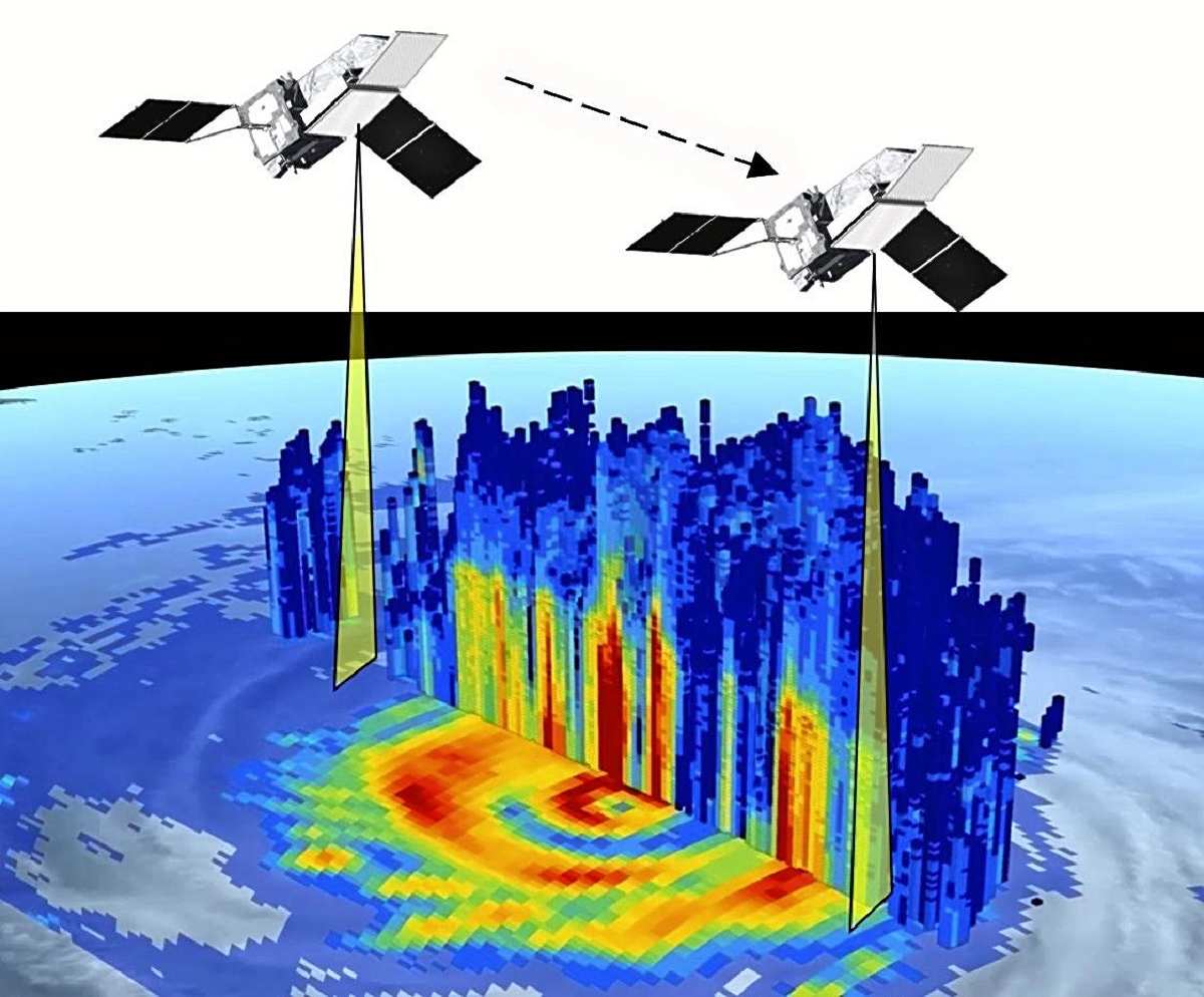
A graphical representation of the kind of data that the Precipitation Radar satellite will collect from a typhoon
1:00 JST, October 24, 2023
The Japan Aerospace Exploration Agency (JAXA) has initiated the development of a new Precipitation Radar satellite with the goal of enhancing the accuracy of heavy rain and flood forecasts by accurately measuring rain and snowfall from space using radio waves. The radar system it will carry boasts world-class capabilities, including the ability to measure the speed of falling raindrops. The satellite is scheduled for launch by the end of fiscal 2028.
Currently, the “Global Precipitation Measurement (GPM) core observatory,” launched in 2014 through collaboration among Japan, the United States and others, is in operation. The new satellite will not only be capable of measuring the speed of falling raindrops but will also have more than double the sensitivity of its predecessors, enabling it to detect even light rainfall. This improved capability will allow for more accurate measurements of precipitation over the seas south of Japan, leading to enhanced predictions of typhoon paths and intensity.
In addition, JAXA has been publishing “precipitation maps” based on satellite data, including data from GPM. These maps categorize global precipitation on an hourly basis and are used in over 140 countries for flood forecasting and monitoring of extreme weather events. With the addition of data from the new satellite, the resolution of these precipitation maps will significantly increase, making it possible to predict floods in smaller rivers.
The new satellite will weigh a maximum of 2.7 tons, with a total development cost of ¥39.4 billion. Development officially began this summer.
A JAXA representative said, “With the intensification of heavy rain-induced disasters worldwide due to climate change, we hope that the new satellite will contribute to reducing the damage.”
Related Tags
-250x155.jpg)


Most Read
Most read in the last 24 hours
-

Japan Monitoring Situation Surrounding Revocation of Taiwan Presi...
-

Promote Support, Respect to Help Prevent Harassment of Athletes
-

3 Japanese Megabanks Mull Loaning ¥3.6 Tril. as Part of Huge Inve...
-

Japan Should Serve as Bridge between Nuclear, Non-nuclear States,...
-

Japanese Company Zoom Wins ¥180 Mil. Lawsuit Against U.S. Operat...
-

Yamato Museum Reopens in Hiroshima Pref. Following Extensive Reno...
-

Man Admits to Abandoning Wife's Body in Zoo Incinerator in Hokkai...
-
Elegant Weeping Cherry Blossoms on Display at Water Purification ...
Most read in the last 7 days
-
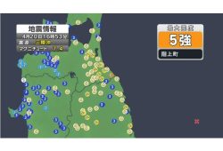
Earthquake Hits Japan's Tohoku Region; 3-meter Tsunami Warning Is...
-

Trump Extends the Ceasefire with Iran but Keeps the Blockade
-

China, South Korea Object to Japanese PM Takaichi's Ritual Offeri...
-

India's Arms Indigenization Quest for Self-Reliance / New Delhi S...
-
Japan to Ban Use of Portable Chargers on Airplanes from April 24,...
-

¥1,000 Coins to Be Issued to Mark Anniversary of Beginning of Jap...
-

Most Serious Cyberattacks against the UK Now from Russia, Iran an...
-

Trump Opposes United–American Merger, Signals Support for Spirit
Most read in the last 30 days
-
Earthquake Hits Japan's Tohoku Region; 3-meter Tsunami Warning Is...
-

Police Find Child's Shoe During Search for Missing Boy in Nantan,...
-
Body Found in Nantan, Kyoto Prefecture, During Search for 11-Year...
-

Cherry Blossoms, Rapeseed Flowers Perform Colorful ‘Duet’ in Niig...
-
Trump Extends the Ceasefire with Iran but Keeps the Blockade
-

Olympic Gold Medal-Winning Figure Skaters Riku-Ryu Announce Retir...
-
China, South Korea Object to Japanese PM Takaichi's Ritual Offeri...
-
Japanese Prime Minister Takaichi Speaks to Pakistani Prime Minist...
Top Articles in Science & Nature
-

Govt Aims to Establish Bear Population Control by FY30, Hopes to Achieve ‘Coexistence’ with Bears
-
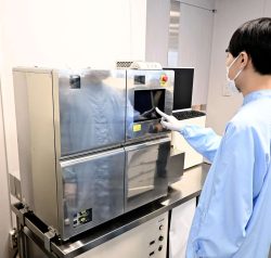
Japan’s Panasonic Develops Automated System to Produce Ips Cells from Patient’s Blood
-
Punch The Monkey Getting Used to Life Without Stuffed ‘Mother’
-

‘Electric Aircraft’ to Begin Test Flights from Kitakyushu Airport, Aiming for Practical Use in Cargo Transport Route
-

New Robotics Center to Conduct Experiments Around the Clock; New Facility Aims to Accelerate Research Efforts
JN ACCESS RANKING
-
Earthquake Hits Japan’s Tohoku Region; 3-meter Tsunami Warning Issued (Update 1)
-
Police Find Child’s Shoe During Search for Missing Boy in Nantan, Kyoto Prefecture
-
Body Found in Nantan, Kyoto Prefecture, During Search for 11-Year-Old Boy in Area (Update 1)
-
Cherry Blossoms, Rapeseed Flowers Perform Colorful ‘Duet’ in Niigata
-
Trump Extends the Ceasefire with Iran but Keeps the Blockade
Most read in the last 24 hours
-
Japan Monitoring Situation Surrounding Revocation of Taiwan Presi...
-
Promote Support, Respect to Help Prevent Harassment of Athletes
-
3 Japanese Megabanks Mull Loaning ¥3.6 Tril. as Part of Huge Inve...
-
Japan Should Serve as Bridge between Nuclear, Non-nuclear States,...
-
Japanese Company Zoom Wins ¥180 Mil. Lawsuit Against U.S. Operat...
Most read in the last 7 days
-
Earthquake Hits Japan's Tohoku Region; 3-meter Tsunami Warning Is...
-
Trump Extends the Ceasefire with Iran but Keeps the Blockade
-
China, South Korea Object to Japanese PM Takaichi's Ritual Offeri...
-
India's Arms Indigenization Quest for Self-Reliance / New Delhi S...
-
Japan to Ban Use of Portable Chargers on Airplanes from April 24,...
Most read in the last 30 days
-
Earthquake Hits Japan's Tohoku Region; 3-meter Tsunami Warning Is...
-
Police Find Child's Shoe During Search for Missing Boy in Nantan,...
-
Body Found in Nantan, Kyoto Prefecture, During Search for 11-Year...
-
Cherry Blossoms, Rapeseed Flowers Perform Colorful ‘Duet’ in Niig...
-
Trump Extends the Ceasefire with Iran but Keeps the Blockade