To use this site, please disable the ad blocking feature and reload the page.
This website uses cookies to collect information about your visit for purposes such as showing you personalized ads and content, and analyzing our website traffic. By clicking “Accept all,” you will allow the use of these cookies.
Users accessing this site from EEA countries and UK are unable to view this site without your consent. We apologize for any inconvenience caused.
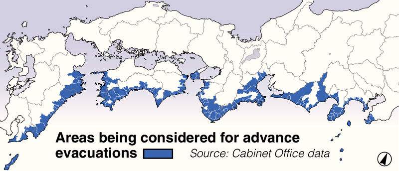
The government plans to develop a framework to map areas where advance evacuations will be issued in the event of a huge Nankai Trough earthquake, which is forecast to occur in the next 30 years.
The system will utilize data from an evacuation drill app developed by Kyoto University and the National Research Institute for Earth Science and Disaster Resilience (NIED).
The ministry will analyze data from the app on evacuation success rates in each region, among other things, and use the analysis to help municipalities devise relevant countermeasures.
The Education, Culture, Sports, Science and Technology Ministry will conduct trials in Kochi and other prefectures this year, aiming to launch the system by fiscal 2024.
There is a 70-80% probability that a Nankai Trough earthquake will occur within the next 30 years, and it is estimated that up to 320,000 people will be killed or be unaccounted for.
In the past, there have been cases where earthquakes occurred simultaneously along the entire length of the Nankai Trough, as well as cases where earthquakes occurred on either the eastern or western part of the Nankai Trough, followed by quakes on the opposite side.
Under a 2019 Cabinet Office proposal, in the event of a Nankai Trough earthquake on either the eastern or western side of the trough, one-week evacuations would be urged for residents in areas at high risk of tsunami in anticipation of a quake on the opposite side of the trough.
This is because, after a massive quake of magnitude 8 or higher on one half of the Nankai Trough region, a quake of similar magnitude occurring on the opposite side is 100 times more likely to occur, according to Cabinet Office estimates.
Advance evacuations will be recommended mainly by municipalities, including areas in Tokyo and 13 other prefectures, including Shizuoka, Mie, Wakayama, and Kochi.
However, data that would serve as a basis for designating such areas has been lacking.
The technology ministry’s framework will utilize data from the Kyoto University and NIED-developed evacuation training smartphone app, which uses the GPS to record location information and includes details about flooding status.
Data such as gender, age, assistance requirements, means of transportation and evacuation success rates will be collected from the app to be used by evacuation drill participants, helping to evaluate the effectiveness of evacuation maps.
Municipalities will utilize the analysis to determine which areas need to be evacuated in advance.
The ministry will analyze data collected from the app during evacuation drills this year in such prefectures as Kochi and Wakayama, and later expand the analysis to include Aichi and Shizuoka, among other prefectures.
The framework is part of a fiscal 2020-24 Nankai Trough quake research project that is expected to contribute to disaster-prevention measures.
An official of the ministry’s earthquake and disaster-reduction research division said, “We hope that by providing objective evidence, it will be easier to gain understanding from the public regarding advance evacuations.”