To use this site, please disable the ad blocking feature and reload the page.
This website uses cookies to collect information about your visit for purposes such as showing you personalized ads and content, and analyzing our website traffic. By clicking “Accept all,” you will allow the use of these cookies.
Users accessing this site from EEA countries and UK are unable to view this site without your consent. We apologize for any inconvenience caused.
The Washington Post / Scott Dance, Karin Brulliard, Tim Craig, Brittany Shammas
15:06 JST, September 27, 2022
Evacuation orders expanded by the hour along Florida’s Gulf Coast on Monday as officials warned residents to prepare for powerful, widespread impacts from a strengthening Hurricane Ian – a storm on its way to becoming the first significant hurricane to hit the state since 2018. The broad threat meant officials were urging preparation up and down the state, including calls to evacuate even short distances to avoid the worst of the storm.
“This thing is coming this week,” Gov. Ron DeSantis (R) said at a news briefing Monday. “We know we’re going to have some major impacts throughout the state of Florida.”
But first, Ian was expected to slam western Cuba as a “major” hurricane Monday night – bringing with it destructive winds and surging floodwaters. Major hurricanes are Category 3 or above and pack sustained winds of more than 111 mph, and as of 5 p.m. Monday, Ian’s winds had surged to 100 mph.
Though it remains uncertain where Ian will strike Florida – weather forecasting models continue to suggest landfall anywhere between the Tampa Bay and Panhandle regions – even a glancing blow could produce significant coastal flooding and damage. Florida is under a state of emergency, and DeSantis told residents to expect power outages, fuel disruptions and flooding. Ian is expected to pass west of the Florida Keys late Tuesday and move slowly up the state Wednesday and Thursday, probably sending a prolonged surge of floodwaters and deluge of rain onto its western shores.
Hillsborough County, which includes the city of Tampa, issued a mandatory evacuation of its coastal areas starting at 2 p.m. Monday. Hernando and Manatee counties to its north and south issued evacuation orders effective as of Tuesday morning. In Pinellas County, home to St. Petersburg and some of the region’s most famed beaches, mandatory evacuations began at 6 p.m. for coastal residents and residents of some 44,000 mobile homes. A wider evacuation order for Pinellas was set to take effect early Tuesday.
In South Florida, the outer bands of Ian were already spawning thunderstorms and minor flooding in the Miami metro area on Monday.
As rain also pushed into Southwest Florida, residents rushed to complete last-minute preparations, including filling up their gas tanks and flocking into stores to buy bottled water and bags of ice. Shortly before 5 p.m., residents were jolted by an emergency alert on their cellphones warning them that they needed to “urgently complete efforts to protect life and property.”
In Punta Gorda, near Fort Meyers, people appeared particularly uneasy, recalling how their community was devastated during Hurricane Charley in 2004. That storm was also forecast to hit Tampa, about 100 miles to the north, but abruptly swerved into Punta Gorda with only a few hours of notice.
Brick Sanders, 38, said Punta Gorda residents have been “freaking out,” adding: “That is why there is no gas, or water anywhere, and people started freaking out days ago.”
By 5 p.m. Monday, as Ian strengthened into a Category 2 storm 155 miles southeast of Cuba’s western tip, hurricane warnings were issued for the central portion of Florida’s Gulf Coast, including Tampa Bay, and for Dry Tortugas National Park off the coast of Florida. That means there is a likelihood of hurricane-force winds of at least 74 mph within the next 24 to 36 hours. Tropical storm warnings – a forecast of likely 39 to 73 mph winds within the next 36 hours – were in effect for Florida’s southwestern coastline and the lower Florida Keys.
In areas surrounding Tampa Bay, storm surge warnings were also issued, indicating that a storm-driven surge of ocean water over normally dry land could be on the way. National Weather Service forecasters urged residents to prepare for the possibility of impassable roads, power and communication outages and buildings rendered uninhabitable.
The sight of stores putting their hurricane shutters in place was enough to convince Nir and Dana Katan to retreat from Key West on Monday. The couple, their three children and other relatives were visiting from Israel, beginning a three-week vacation crisscrossing Florida. But with warnings of flooding and tropical storm-force winds at the state’s southernmost point, they decided to head to Orlando and St. Augustine rather than continue onto Marco Island on the southwest side of the state as planned.
“Not for me,” Dana Katan said of staying in the Keys for the storm. “Not for the children.”
In a morning update, Tampa Mayor Jane Castor (D) warned residents that “Ian is coming – even though he is not invited – and we are going to feel the effects one way or the other.”
But first, the storm was expected to ravage Cuba overnight Monday into Tuesday. The Associated Press reported that authorities in Cuba were evacuating 50,000 people in Pinar del Rio province, sending in medical and emergency personnel, and taking steps to protect food and other crops in warehouses, according to state media.
The storm was expected to pass relatively quickly over Cuba on Monday night into Tuesday, the hurricane center said, before approaching Florida and then slowing to a crawl. It was moving northwest at about 13 mph throughout the day Monday but is forecast to turn northward and eventually northeast at significantly slower speeds by Wednesday.
That slowing along Florida’s west coast could translate to more damage, warned Scott Hopes, Manatee County’s administrator.
What it means, he said, is strong winds whipping the area from Tuesday evening through early Friday: “48 hours of hurricane- or tropical storm-force winds and rain and storm surge, in a relentless fashion, without a break.”
Jamie Rhome, the National Hurricane Center’s acting director, told CNN that it meant a “near worst-case scenario” for the Tampa region.
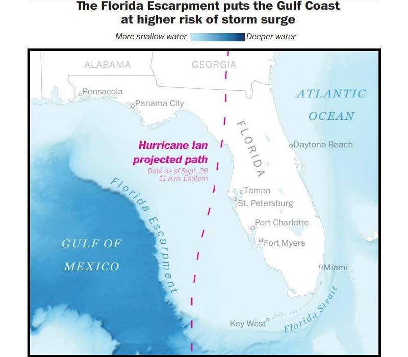
The center predicts 5 to 8 feet of storm surge will be possible along Florida’s Gulf Coast, and even in areas that avoid a direct hit, coastal flooding could be dramatic. Pinellas County’s emergency management director, Cathie Perkins, likened the storm surge to “a wall of water” that could push houses off their foundations, wash out roads and flood electrical equipment that powers high-rise elevators. The gentle slope of the continental shelf off the Florida coastline can greatly exacerbate storm surge risk, with even a minimal hurricane capable of causing serious coastal inundation.
Under evacuation orders, Pinellas officials said, residents would not be forced out, but emergency workers would not respond to calls for assistance.
“We’re not coming, because we’re not going to put our people in harm’s way,” Sheriff Bob Gualtieri said, adding: “This is the real deal. This is serious. There’s every indication that we’re going to have real impact here in Pinellas County.”
President Biden approved an emergency declaration Saturday for Florida, authorizing the Federal Emergency Management Agency to coordinate disaster-relief efforts and provide more federal funding. The Florida National Guard has activated 5,000 troops, DeSantis said Monday, and is bringing in 2,500 troops from neighboring states.
The storm’s track and intensity remained uncertain Monday evening, with computer models divided on whether Ian will come ashore along Florida’s west coast on Wednesday into Thursday, or chart a course nearer to the Panhandle on Thursday into Friday.
The source of uncertainty is how Ian will interact with other weather systems, including a trough, or dip in the jet stream, that could pull the storm eastward as it approaches Florida. European and American weather forecasting models continue to disagree on how that dynamic could play out, making the forecast a tenuous and challenging one. For the state’s densely populated Gulf Coast, a difference of 40 miles in the storm’s track to the east or west could be the difference between experiencing only tropical storm conditions and Ian’s most destructive winds. Either scenario remained plausible Monday.
Ian strengthened rapidly overnight Sunday into Monday, going from a low-end tropical storm with 45 mph winds to hurricane force with 75 mph winds within 12 hours. The storm is forecast to continue to rapidly intensify into Tuesday, as it moves over exceptionally warm waters.
Ian is predicted to peak as a 140 mph Category 4 hurricane west of the Florida Straits late Tuesday or early Wednesday, which would make it the strongest September hurricane to pass through the Gulf of Mexico since Rita in 2005.
Warm waters and copious Gulf moisture mean Ian brings the threat of flooding rains along with its storm surge. Western Cuba was forecast to get 6 to 10 inches of rain and as much as 16 inches in some spots, potentially triggering flash flooding and mudslides through Thursday, according to the National Hurricane Center. Heavy rainfall is also forecast over the Cayman Islands, where 3 to 6 inches – and a maximum of 8 inches – are possible.
Meanwhile, central western Florida could face 8 to 10 inches of rain, and the rest of the Florida Peninsula could see up to 8 inches.
Ian is the sixth named storm to form this month, coming on the heels of a record-quiet August, during which not a single named storm formed. The cyclone began its rapid intensification Sunday night, when a large “convective burst,” or blossoming of thunderstorm activity, occurred near the center of the then-ragged storm, allowing the system to organize around a column of swirling winds.
The storm will pass well west of the Florida Straits on Tuesday but could still bring tides two to four feet higher than normal for the Keys. It’s worth noting that much of Key West, for example, sits only three feet above sea level, so even “minor” surges can become high-impact flood events.
Ian will continue gaining strength in the southeastern Gulf of Mexico, aided in particular by favorable upper-level winds that help evacuate spent “exhaust” air away from the storm’s center. The more air that exits a storm from above, the more moisture-rich air that can spiral inward and fuel it from below. But then it is expected to weaken slightly before it makes landfall somewhere on Florida’s coast.
After the storm makes landfall, gusty squalls, heavy rainfall and a few tornadoes are possible over the Southeast, including Georgia and the Carolinas, late into the week and into the weekend.