To use this site, please disable the ad blocking feature and reload the page.
This website uses cookies to collect information about your visit for purposes such as showing you personalized ads and content, and analyzing our website traffic. By clicking “Accept all,” you will allow the use of these cookies.
Users accessing this site from EEA countries and UK are unable to view this site without your consent. We apologize for any inconvenience caused.
By Yuichi Morii and Daisuke Kawakami Yomiuri Shimbun Correspondents
15:40 JST, January 18, 2022
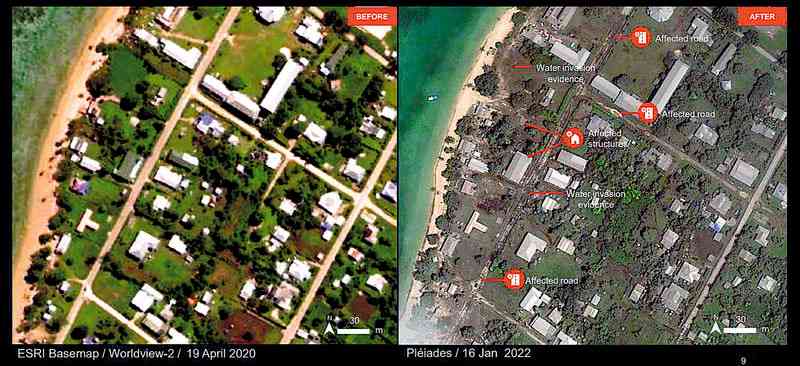
GENEVA/JAKARTA — The United Nations Satellite Center (UNOSAT) on Monday released satellite images showing Saturday’s eruption of an undersea volcano off Tonga in the South Pacific and the impact of tsunami caused by it.
One image shows a coastal area flooded by tsunami and inundated buildings in a village near Nuku’alofa, Tong’s capital. Another shows the islands around the volcano covered with volcanic ash.
A British woman living in Tonga was confirmed dead, BBC has reported after it obtained the information from a relative of the woman. The woman, 50, was engaged in activities to rescue stray dogs and other animals with her husband. It was believed that she was swept away by tsunami while trying to save a dog, which would make this case the first death from the disaster.
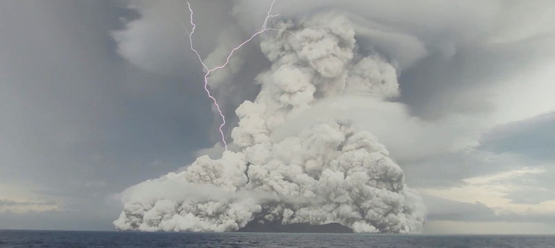
Tonga Geological Services via Reuters This screen grab obtained from a social media video shows an eruption of the underwater volcano Hunga Tonga-Hunga Ha’apai off Tonga on Friday. The volcano was active prior to Saturday’s eruption.
The United Nations Office for the Coordination of Humanitarian Affairs (OCHA) said Monday that a distress signal had been detected from a Tongan island believed to have more than 30 residents. It also said a resort in the western part of Tongatapu, the island home to the capital, was severely damaged by tsunami.