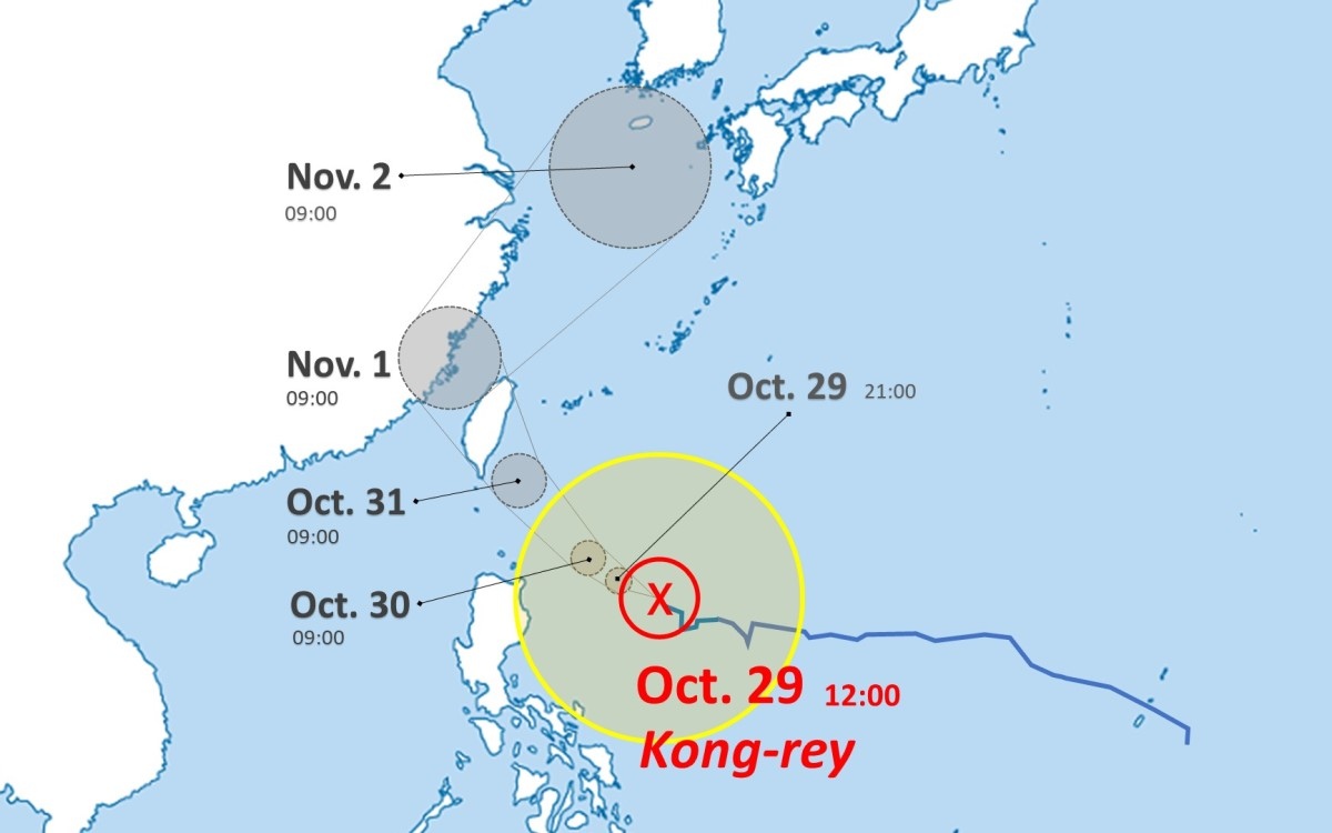
13:25 JST, October 29, 2024
The large Typhoon Kong-rey, was moving west-northwest at a speed of about 15 kilometers per hour east of the Philippines as of noon on Tuesday. It is expected to develop into a very strong typhoon and pass near the Sakishima Islands in Okinawa Prefecture, bringing strong winds and rain.
According to the Japan Meteorological Agency, as of noon on Tuesday, the central pressure of Typhoon Kong-rey was 960 hPa, and the maximum wind speed near the center was 40 m/s. After that, it is likely to develop to a central pressure of 925 hPa and the maximum wind speed of 50 m/s, and it is expected to pass south of the Sakishima Islands on Thursday.
Even if the course is distant, there is a high risk of rough seas with high waves and storms in Okinawa, mainly in the Sakishima Islands.
Related Tags


Most Read
Most read in the last 24 hours
-

Trump Extends the Ceasefire with Iran but Keeps the Blockade
-

China, South Korea Object to Japanese PM Takaichi's Ritual Offeri...
-

Florida Launches Criminal Probe into OpenAI and ChatGPT over Dead...
-

Trump Opposes United–American Merger, Signals Support for Spirit
-

Trump Picks a University of Minnesota Professor to Lead His Econo...
-

Japan's ANA to Introduce Fuel Surcharges to Domestic Flights from...
-

Taiwan President Cancels Africa Trip Blaming Chinese Pressure
-

Fired Former UK Official Says He Felt Political Pressure to Appro...
Most read in the last 7 days
-
Earthquake Hits Japan's Tohoku Region; 3-meter Tsunami Warning Is...
-
Trump Extends the Ceasefire with Iran but Keeps the Blockade
-

Olympic Gold Medal-Winning Figure Skaters Riku-Ryu Announce Retir...
-
China, South Korea Object to Japanese PM Takaichi's Ritual Offeri...
-

Japan to Ban Use of Portable Chargers on Airplanes from April 24,...
-

New Challenges Await as Miura-Kihara Retires; Blade Maker, Ex-Coa...
-
Florida Launches Criminal Probe into OpenAI and ChatGPT over Dead...
-
Trump Opposes United–American Merger, Signals Support for Spirit
Most read in the last 30 days
-
Earthquake Hits Japan's Tohoku Region; 3-meter Tsunami Warning Is...
-

Police Find Child's Shoe During Search for Missing Boy in Nantan,...
-

Body Found in Nantan, Kyoto Prefecture, During Search for 11-Year...
-

Cherry Blossoms, Rapeseed Flowers Perform Colorful ‘Duet’ in Niig...
-
Trump Extends the Ceasefire with Iran but Keeps the Blockade
-
Olympic Gold Medal-Winning Figure Skaters Riku-Ryu Announce Retir...
-

Nori Prices Surge in Japan Due to Poor Seaweed Production Amid Ri...
-

Japanese Prime Minister Takaichi Speaks to Pakistani Prime Minist...
Top Articles in Society
-
Earthquake Hits Japan’s Tohoku Region; 3-meter Tsunami Warning Issued (Update 1)
-
Police Find Child’s Shoe During Search for Missing Boy in Nantan, Kyoto Prefecture
-
Body Found in Nantan, Kyoto Prefecture, During Search for 11-Year-Old Boy in Area (Update 1)
-
Cherry Blossoms, Rapeseed Flowers Perform Colorful ‘Duet’ in Niigata
-

Two Women in Osaka Found Lying on Floor Bleeding, Later Pronounced Dead
JN ACCESS RANKING
-
Earthquake Hits Japan’s Tohoku Region; 3-meter Tsunami Warning Issued (Update 1)
-
Police Find Child’s Shoe During Search for Missing Boy in Nantan, Kyoto Prefecture
-
Body Found in Nantan, Kyoto Prefecture, During Search for 11-Year-Old Boy in Area (Update 1)
-
Cherry Blossoms, Rapeseed Flowers Perform Colorful ‘Duet’ in Niigata
-
Trump Extends the Ceasefire with Iran but Keeps the Blockade
Most read in the last 24 hours
-
Trump Extends the Ceasefire with Iran but Keeps the Blockade
-
China, South Korea Object to Japanese PM Takaichi's Ritual Offeri...
-
Florida Launches Criminal Probe into OpenAI and ChatGPT over Dead...
-
Trump Opposes United–American Merger, Signals Support for Spirit
-
Trump Picks a University of Minnesota Professor to Lead His Econo...
Most read in the last 7 days
-
Earthquake Hits Japan's Tohoku Region; 3-meter Tsunami Warning Is...
-
Trump Extends the Ceasefire with Iran but Keeps the Blockade
-
Olympic Gold Medal-Winning Figure Skaters Riku-Ryu Announce Retir...
-
China, South Korea Object to Japanese PM Takaichi's Ritual Offeri...
-
Japan to Ban Use of Portable Chargers on Airplanes from April 24,...
Most read in the last 30 days
-
Earthquake Hits Japan's Tohoku Region; 3-meter Tsunami Warning Is...
-
Police Find Child's Shoe During Search for Missing Boy in Nantan,...
-
Body Found in Nantan, Kyoto Prefecture, During Search for 11-Year...
-
Cherry Blossoms, Rapeseed Flowers Perform Colorful ‘Duet’ in Niig...
-
Trump Extends the Ceasefire with Iran but Keeps the Blockade