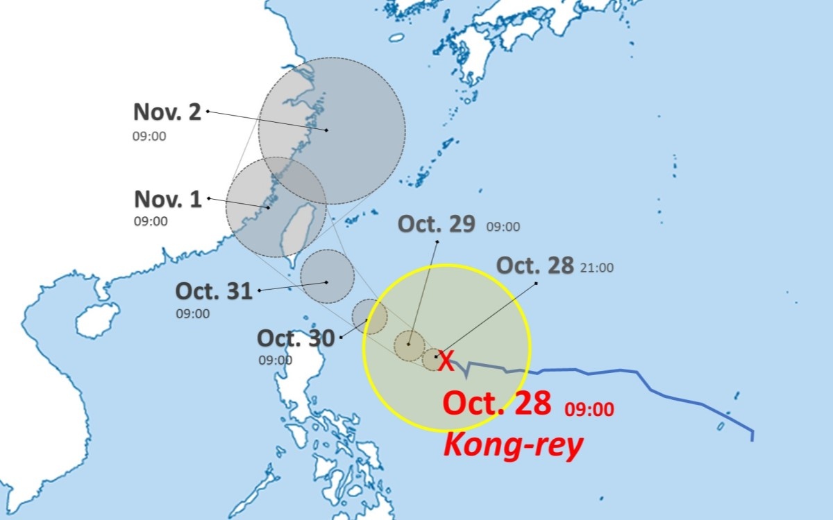
Typhoon Kong-rey Expected to Turn into Tropical Storm after Possible Pass Over Taiwan
13:24 JST, October 28, 2024
The large Typhoon Kong-rey is expected to turn into a tropical storm on Saturday in the East China Sea after a possible pass over Taiwan around Friday, according to the Japan Meteorological Agency.
The agency said that the typhoon, also referred to as Typhoon No. 21, was east of the Philippines as of 9 a.m. Monday. Its central pressure was 985 hectopascals and its maximum instantaneous wind speed was 35 meters per second, or 126 kph. The typhoon was moving west-northwest at a speed of 10 kph.
The agency added that after passing over Taiwan or nearby areas on Friday, the typhoon is expected to change course and travel northeast, turning into a tropical storm near the eastern coast of China on Saturday.
Related Tags


Most Read
Most read in the last 24 hours
-

Trump Extends the Ceasefire with Iran but Keeps the Blockade
-

China, South Korea Object to Japanese PM Takaichi's Ritual Offeri...
-

Florida Launches Criminal Probe into OpenAI and ChatGPT over Dead...
-

Trump Opposes United–American Merger, Signals Support for Spirit
-

Trump Picks a University of Minnesota Professor to Lead His Econo...
-

Japan's ANA to Introduce Fuel Surcharges to Domestic Flights from...
-

Taiwan President Cancels Africa Trip Blaming Chinese Pressure
-

Fired Former UK Official Says He Felt Political Pressure to Appro...
Most read in the last 7 days
-
Earthquake Hits Japan's Tohoku Region; 3-meter Tsunami Warning Is...
-
Trump Extends the Ceasefire with Iran but Keeps the Blockade
-

Olympic Gold Medal-Winning Figure Skaters Riku-Ryu Announce Retir...
-
China, South Korea Object to Japanese PM Takaichi's Ritual Offeri...
-

Japan to Ban Use of Portable Chargers on Airplanes from April 24,...
-

New Challenges Await as Miura-Kihara Retires; Blade Maker, Ex-Coa...
-
Florida Launches Criminal Probe into OpenAI and ChatGPT over Dead...
-
Trump Opposes United–American Merger, Signals Support for Spirit
Most read in the last 30 days
-
Earthquake Hits Japan's Tohoku Region; 3-meter Tsunami Warning Is...
-

Police Find Child's Shoe During Search for Missing Boy in Nantan,...
-

Body Found in Nantan, Kyoto Prefecture, During Search for 11-Year...
-

Cherry Blossoms, Rapeseed Flowers Perform Colorful ‘Duet’ in Niig...
-
Trump Extends the Ceasefire with Iran but Keeps the Blockade
-
Olympic Gold Medal-Winning Figure Skaters Riku-Ryu Announce Retir...
-

Nori Prices Surge in Japan Due to Poor Seaweed Production Amid Ri...
-

Japanese Prime Minister Takaichi Speaks to Pakistani Prime Minist...
Top Articles in Society
-
Earthquake Hits Japan’s Tohoku Region; 3-meter Tsunami Warning Issued (Update 1)
-
Police Find Child’s Shoe During Search for Missing Boy in Nantan, Kyoto Prefecture
-
Body Found in Nantan, Kyoto Prefecture, During Search for 11-Year-Old Boy in Area (Update 1)
-
Cherry Blossoms, Rapeseed Flowers Perform Colorful ‘Duet’ in Niigata
-

Two Women in Osaka Found Lying on Floor Bleeding, Later Pronounced Dead
JN ACCESS RANKING
-
Earthquake Hits Japan’s Tohoku Region; 3-meter Tsunami Warning Issued (Update 1)
-
Police Find Child’s Shoe During Search for Missing Boy in Nantan, Kyoto Prefecture
-
Body Found in Nantan, Kyoto Prefecture, During Search for 11-Year-Old Boy in Area (Update 1)
-
Cherry Blossoms, Rapeseed Flowers Perform Colorful ‘Duet’ in Niigata
-
Trump Extends the Ceasefire with Iran but Keeps the Blockade
Most read in the last 24 hours
-
Trump Extends the Ceasefire with Iran but Keeps the Blockade
-
China, South Korea Object to Japanese PM Takaichi's Ritual Offeri...
-
Florida Launches Criminal Probe into OpenAI and ChatGPT over Dead...
-
Trump Opposes United–American Merger, Signals Support for Spirit
-
Trump Picks a University of Minnesota Professor to Lead His Econo...
Most read in the last 7 days
-
Earthquake Hits Japan's Tohoku Region; 3-meter Tsunami Warning Is...
-
Trump Extends the Ceasefire with Iran but Keeps the Blockade
-
Olympic Gold Medal-Winning Figure Skaters Riku-Ryu Announce Retir...
-
China, South Korea Object to Japanese PM Takaichi's Ritual Offeri...
-
Japan to Ban Use of Portable Chargers on Airplanes from April 24,...
Most read in the last 30 days
-
Earthquake Hits Japan's Tohoku Region; 3-meter Tsunami Warning Is...
-
Police Find Child's Shoe During Search for Missing Boy in Nantan,...
-
Body Found in Nantan, Kyoto Prefecture, During Search for 11-Year...
-
Cherry Blossoms, Rapeseed Flowers Perform Colorful ‘Duet’ in Niig...
-
Trump Extends the Ceasefire with Iran but Keeps the Blockade